close
-
Layers w
- Weather Layers
- Pro
- Pro
- Pro
- Pro
- Pro
- Pro
- More Layers
- Pro
- Pro
- Pro
- Pro
-
Upgrade to

3D
Trail Conditions
- Unknown
- Snow Groomed
- Snow Packed
- Snow Covered
- Snow Cover Partial
- Freeze/thaw Cycle
- Icy
- Prevalent Mud
- Wet
- Variable
- Ideal
- Dry
- Very Dry
Trail Flow (Ridden Direction)
Trailforks scans users ridelogs to determine the most popular direction each trail is ridden. A good flowing trail network will have most trails flowing in a single direction according to their intension.
The colour categories are based on what percentage of riders are riding a trail in its intended direction.
The colour categories are based on what percentage of riders are riding a trail in its intended direction.
- > 96%
- > 90%
- > 80%
- > 70%
- > 50%
- < 50%
- bi-directional trail
- no data
Trail Last Ridden
Trailforks scans ridelogs to determine the last time a trail was ridden.
- < 2 days
- < 1 week
- < 2 weeks
- < 1 month
- < 6 months
- > 6 months
Trail Ridden Direction
The intended direction a trail should be ridden.
- Downhill Only
- Downhill Primary
- Both Directions
- Uphill Primary
- Uphill Only
- One Direction
Contribute Details
Colors indicate trail is missing specified detail.
- Description
- Photos
- Description & Photos
- Videos
Trail Popularity ?
Trailforks scans ridelogs to determine which trails are ridden the most in the last 9 months.
Trails are compared with nearby trails in the same city region with a possible 25 colour shades.
Think of this as a heatmap, more rides = more kinetic energy = warmer colors.
- most popular
- popular
- less popular
- not popular
ATV/ORV/OHV Filter
Max Vehicle Width
inches
US Cell Coverage
Legend

Radar Time
Activity Recordings
Trailforks uses anonymized public activity data.
?
Activity Recordings
Trailforks uses anonymized public activity data.
?
Personal Heatmap
▶
Activity Types
all
/
none
▶
Options
2
Date range
month
–
Winter Trails
Warning
A routing network for winter maps does not exist. Selecting trails using the winter trails layer has been disabled.
Missing Trails
Most Popular
Least Popular
Trails are colored based on popularity. The more popular a trail is, the more red. Less popular trails trend towards green.
Jump Magnitude Heatmap
Heatmap of where riders jump on trails. Zoom in to see individual jumps, click circles to view jump details.
BC Backroad Status
![map legend]()
Service Road Atlas is a free to use, community-driven service for viewing and creating reports on the numerous back-country service roads around B.C. and Alberta.

Slope Aspect
Direction the slope faces
Trails Deemphasized
Trails are shown in grey.
Only show trails with no bike usage.
Suggested Layers
Based on selected activity type
Save the current map location and zoom level as your default home location whenever this page is loaded.
Save
No description for Menaggio has been added yet!
Login or register to submit one.
This region uses the Uk/Euro style trail grading system.
Activities Click to view
- Mountain Bike
44 trails
- E-Bike
44 trails
- Gravel Bike
1 trails
- Adaptive Bike
0 trails
- Hike
44 trails
- Trail Running
44 trails
Region Details
- 7
- 9
- 20
- 1
Region Status
Caution as of Jun 17, 2026Stats
- Avg Trail Rating
- Trails (view details)
- 41
- Trails Mountain Bike
- 44
- Trails E-Bike
- 44
- Trails Gravel Bike
- 1
- Trails Horse
- 1
- Trails Hike
- 44
- Trails Trail Running
- 44
- Total Distance
- 46 miles
- Total Descent
- 30,683 ft
- Total Vertical
- 4,420 ft
- Highest Trailhead
- 5,282 ft
- Reports
- 537
- Photos
- 118
- Ridden Counter
- 993
Popular Menaggio Mountain Biking Trails
• 100 ★ 4.2 • 5 miles • 284 ft • 213 •
Discesa divertente, senza niente di difficile. Parte iniziale un po’ esposta ma il trail è molto largo.
• 100 ★ 3.8 • 2 miles • 16 ft • 80 •
Primo pezzo facile su mulattiera cementata poi inizia il pezzo un po’ divertente con qualche passaggio scassato
• 90 ★ 4.4 • 3 miles • 1,074 ft • 33 •
La discesa più iconica e adrenalinica della zona. Alcuni tratti esposti e qualche passaggio tecnico ma fattibile quasi tutta in sella. Vista e paesaggio bellissimo.
• 95 ★ 4.0 • 3,287 ft • 0 ft • 28 •
Bel trail veloce e divertente uno dei pochi sempre pulito
• 85 ★ 5.0 • 2 miles • 335 ft • 28 •
Bel collegamento tra e carcente ,è il vecchio sentiero tenuto abbastanza bene
• 95 ★ 4.2 • 4,557 ft • 23 ft • 24 •
Bella discesa primo pezzo flow e veloce, facile,poi diventa un po' impegnativa con tratti ripidi ma fattibili poi tratti un po' pedalati in uno scenario fantastico in un parco naturale
• 75 ★ 4.4 • 2 miles • 179 ft • 23 •
Primo pezzo un po' difficile poi un po' più flow ma con passaggi tecnici
Menaggio Mountain Bike Routes
23 miles • 5,536 ft • 1 • Loop •
Il percorso inizia prendendo la funicolare ad Argegno per Pigra. Qui si inizia a pedalare su strada...
8 miles • 696 ft • 0 • Point to Point •
Questo itinerario segue in parte il tracciato della ferrovia che dal 1884 al 1939 ha collegato Menaggio...
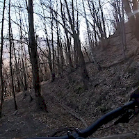
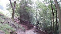
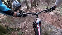
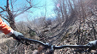
Photos of Menaggio Mountain Bike
Videos of Menaggio Mountain Bike

trail: Canua
2:41 |
137 |
Jan 7, 2020
trail: Cavarzo trail
2:11 |
178 |
Jan 7, 2020
trail: Varoo ponte trail
0:48 |
311 |
Aug 6, 2019
trail: Ponte trail
0:00 |
291 |
Apr 30, 2019

trail: Crocione dh
0:31 |
519 |
Mar 23, 2019
trail: Crocetta trail
3:25 |
112 |
Mar 23, 2019

trail: Brichera official
7:06 |
29 |
Dec 31, 2025 , Menaggio
trail: Cavarzo trail
7:06 |
41 |
Dec 31, 2025 , Menaggio
Recent Trail Reports
| status | trail | date | condition | info | user |
|---|---|---|---|---|---|
| Rogaro DH | Jun 17, 2026 @ 11:16am (America/Vancouver) Jun 17, 2026 | Ideal | AlbertokKbRr1 | ||
| Crocione dh | Jun 17, 2026 @ 11:15am (America/Vancouver) Jun 17, 2026 | Ideal | AlbertokKbRr1 | ||
| Nava climbing | Jun 14, 2026 @ 9:14am (Europe/Vaduz) Jun 14, 2026 | Ideal | Pinetto | ||
| Ponte trail | Jun 11, 2026 @ 7:02pm (Europe/Vaduz) Jun 11, 2026 | Ideal | Pinetto | ||
| Ponte gravel access | Jun 11, 2026 @ 7:02pm (Europe/Vaduz) Jun 11, 2026 | Ideal | Pinetto | ||
| Carcente | Jun 4, 2026 @ 9:13am (Europe/Vaduz) Jun 4, 2026 | Ideal | Pinetto | ||
| Lacinghiale | May 29, 2026 @ 5:45pm (Europe/Vaduz) May 29, 2026 | Ideal | Pinetto | ||
| LaCerva | Apr 24, 2026 @ 4:54pm (Europe/Vaduz) Apr 24, 2026 | Ideal | Pinetto | ||
| Bocchette di Nava DH | Apr 12, 2026 @ 7:55am (Europe/Rome) Apr 11, 2026 | Ideal | ALF71 | ||
| Breglia | Apr 4, 2026 @ 9:45am (Europe/Vaduz) Apr 4, 2026 | Ideal | Polva64 |
Activity Feed
| username | action | type | title | date |
|---|---|---|---|---|
| Loca83 | ridden | trail | activity #98390838 | Jul 4, 2026 @ 12:21am 1 day |
| AlbertokKbRr1 | difficultyvote | trail | activity #97197645 | Jun 17, 2026 @ 11:15am Jun 17, 2026 |
| AlbertokKbRr1 | checkin | trail | activity #97197616 and 1 more | Jun 17, 2026 @ 11:15am Jun 17, 2026 |
| AlbertokKbRr1 | add | report | activity #97197614 and 1 more | Jun 17, 2026 @ 11:15am Jun 17, 2026 |
| AlbertokKbRr1 | ridden | trail | activity #97197514 and 1 more | Jun 17, 2026 @ 11:13am Jun 17, 2026 |
Recent Comments
| username | type | title | comment | date |
|---|---|---|---|---|
| trail | L'esposizione è una scala a parte... | Jun 4, 2026 @ 9:50am Jun 4, 2026 | ||
| trail | L'esposizione è una scala a parte... | Jun 4, 2026 @ 9:48am Jun 4, 2026 | ||
| trail | L'esposizione è una scala a parte,... | Jun 4, 2026 @ 7:37am Jun 4, 2026 | ||
| trail | Il Trail non è facilissimo, soprattutto nella... | May 9, 2026 @ 1:27pm May 9, 2026 | ||
| trail | Tecnicamente il trail è semplice, ad... | May 9, 2026 @ 1:20pm May 9, 2026 |
Local Badges
-

Epic Ride Climb 2k246 awarded -

Climbing 10k Badge15 awarded -

Climbing 100k Badge1 awarded -

Epic Ride Descent 2k246 awarded -

Descent 10k Badge15 awarded -

Descent 100k Badge1 awarded
Activity Type Stats
| activitytype | trails | distance | descent | descent distance | total vertical | rating | global rank | state rank | photos | reports | routes | ridelogs |
|---|---|---|---|---|---|---|---|---|---|---|---|---|
| Mountain Bike | 44 | 46 miles | 30,682 ft | 29 miles | 4,419 ft | #2,902 | #139 | 129 | 537 | 2 | 940 | |
| E-Bike | 44 | 46 miles | 30,682 ft | 29 miles | 4,419 ft | #689 | #76 | 2 | 505 | 2 | 338 | |
| Gravel Bike | 1 | #380 | #141 | 4 | ||||||||
| Horse | 1 | 3,438 ft | 92 ft | 1,063 ft | 420 ft | 16 | ||||||
| Hike | 44 | 46 miles | 30,682 ft | 29 miles | 4,419 ft | #4,309 | #175 | 537 | 1 | 196 | ||
| Trail Running | 44 | 46 miles | 30,682 ft | 29 miles | 4,419 ft | #3,757 | #151 | 537 | 1 | 31 |
Frequently Asked Questions About Menaggio
▼
What are the highest rated mountain biking trails in Menaggio?
The highest rated mountain biking trails in Menaggio are:
- Carcente (4.2/5)
- Brichera official (4.2/5)
- Varoo ponte trail (4.2/5)
- Sant'Amate - Breglia (4.2/5)
- Crocetta trail (4.2/5)
▼
What is the best time of the year to ride in Menaggio?
Based on ride log data, the most popular months to ride in Menaggio are:
- June (8 activities)
- September (4 activities)
- August (4 activities)
▼
Where can I park to ride in Menaggio?
There are 1 parking locations listed in Menaggio. The most popular parking spots are:
▼
What is the longest trail in Menaggio?
The longest trail in Menaggio is Crocione dh at 4.8 miles. View all trails sorted by distance.
Activities
Trails
Points of Interest
- By Pinetto
 & contributors
 - Admins: marcoangeletti, adessoomaipiu, micheletraversi, NORTHNLINE, adessoomaipiu
- #24633 - 6,264 views
- menaggio activity log | embed map of Menaggio mountain bike trails | menaggio mountain biking points of interest
Downloading of trail gps tracks in kml & gpx formats is enabled for Menaggio.
You must login to download files.