close
-
Layers w
- Weather Layers
- Pro
- Pro
- Pro
- Pro
- Pro
- Pro
- More Layers
- Pro
- Pro
- Pro
- Pro
-
Upgrade to

3D
Trail Conditions
- Unknown
- Snow Groomed
- Snow Packed
- Snow Covered
- Snow Cover Partial
- Freeze/thaw Cycle
- Icy
- Prevalent Mud
- Wet
- Variable
- Ideal
- Dry
- Very Dry
Trail Flow (Ridden Direction)
Trailforks scans users ridelogs to determine the most popular direction each trail is ridden. A good flowing trail network will have most trails flowing in a single direction according to their intension.
The colour categories are based on what percentage of riders are riding a trail in its intended direction.
The colour categories are based on what percentage of riders are riding a trail in its intended direction.
- > 96%
- > 90%
- > 80%
- > 70%
- > 50%
- < 50%
- bi-directional trail
- no data
Trail Last Ridden
Trailforks scans ridelogs to determine the last time a trail was ridden.
- < 2 days
- < 1 week
- < 2 weeks
- < 1 month
- < 6 months
- > 6 months
Trail Ridden Direction
The intended direction a trail should be ridden.
- Downhill Only
- Downhill Primary
- Both Directions
- Uphill Primary
- Uphill Only
- One Direction
Contribute Details
Colors indicate trail is missing specified detail.
- Description
- Photos
- Description & Photos
- Videos
Trail Popularity ?
Trailforks scans ridelogs to determine which trails are ridden the most in the last 9 months.
Trails are compared with nearby trails in the same city region with a possible 25 colour shades.
Think of this as a heatmap, more rides = more kinetic energy = warmer colors.
- most popular
- popular
- less popular
- not popular
ATV/ORV/OHV Filter
Max Vehicle Width
inches
US Cell Coverage
Legend

Radar Time
Activity Recordings
Trailforks uses anonymized public activity data.
?
Activity Recordings
Trailforks uses anonymized public activity data.
?
Personal Heatmap
▶
Activity Types
all
/
none
▶
Options
2
Date range
month
–
Winter Trails
Warning
A routing network for winter maps does not exist. Selecting trails using the winter trails layer has been disabled.
Missing Trails
Most Popular
Least Popular
Trails are colored based on popularity. The more popular a trail is, the more red. Less popular trails trend towards green.
Jump Magnitude Heatmap
Heatmap of where riders jump on trails. Zoom in to see individual jumps, click circles to view jump details.
BC Backroad Status
![map legend]()
Service Road Atlas is a free to use, community-driven service for viewing and creating reports on the numerous back-country service roads around B.C. and Alberta.

Slope Aspect
Direction the slope faces
Trails Deemphasized
Trails are shown in grey.
Only show trails with no bike usage.
Suggested Layers
Based on selected activity type
Save the current map location and zoom level as your default home location whenever this page is loaded.
Save
No description for Mobile has been added yet!
Login or register to submit one.
Activities Click to view
- Mountain Bike
38 trails
- E-Bike
20 trails
- Gravel Bike
0 trails
- Adaptive Bike
0 trails
- Hike
34 trails
- Trail Running
34 trails
Region Details
- 1
- 3
- 14
- 13
- 5
- 2
Region Status
Open as of Jun 9, 2026Stats
- Avg Trail Rating
- Trails (view details)
- 37
- Trails Mountain Bike
- 46
- Trails E-Bike
- 20
- Trails Hike
- 34
- Trails Trail Running
- 34
- Total Distance
- 43 miles
- Total Descent
- 1,573 ft
- Total Vertical
- 212 ft
- Highest Trailhead
- 215 ft
- Reports
- 82
- Photos
- 43
- Ridden Counter
- 2,695
Sub Regions
-
Chickasabogue State Park
- 3
- 5
- 10
- 1
-
Glenn Sebastian Nature Trails
- 1
-
Pine Hill Mountain Bike Trails
- 1
- 2
- 4
- 2
-
University of South Alabama Trails (USA)
- 7
- 2
Popular Mobile Mountain Biking Trails
• 100 ★ 0.0 • 1 mile • 17 ft • 137 •
is a great introduction to the rooty and winding singletrack trails at South Alabama University. The trail is rooty and winding and traverses generally flat terrain. The trail surface is generally solid and well packed, with...
• 100 ★ 0.0 • 2 miles • 34 ft • 133 •
Popular green difficulty singletrack. This multi-use trail can be used one direction and has a easy overall physical rating with a 34 ft green climb. Trail visibility is always easy to follow. On average it takes 8 minutes to complete this trail.
• 95 ★ 0.0 • 4,154 ft • 12 ft • 120 •
has a number of log obstacles and some of the most technically challenging root sections in the USA network. The trail surface is mostly hard packed with some sand in places. After a pucny clim of about 100 feet at the start from the...
• 90 ★ 0.0 • 1 mile • 38 ft • 104 •
Popular blue difficulty singletrack. This multi-use trail can be used one direction and has a moderate overall physical rating with a 38 ft blue climb. Trail visibility is always easy to follow. On average it takes 5 minutes to complete this trail.
• 90 ★ 0.0 • 2 miles • 56 ft • 104 •
The Mike Thompson Loop has a lot of roots and some of the most technical terrain in the USA network. The trail surface is mostly solid hardpacked with some loose over hard in areas.
• 80 ★ 3.0 • 3,548 ft • 32 ft • 81 •
Popular green difficulty singletrack. This mountain bike primary trail. On average it takes 7 minutes to complete this trail.
• 100 ★ 0.0 • 1 mile • 35 ft • 80 •
is one of the most fun sections of trail in the USA network and offers fast, fun turns with berms and a nice flow. The trail surface is mostly solid and the elevation change is modest with a few punchy climbs and descents. The trail is...
• 70 ★ 0.0 • 3,887 ft • 71 ft • 63 •
Popular blue difficulty singletrack. This mountain bike primary trail. On average it takes 6 minutes to complete this trail.
Mobile Mountain Bike Routes
2,474 ft • 55 ft • 3 • Loop •
This Loop will take you through , , and The Climb Trail. Due to the Climb trail being Uphill only, this...
7 miles • 168 ft • 9 • Loop •
The White Loop is the USA All Stars loop and includes the entire trail system. Starting in the main...
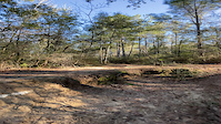
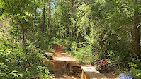
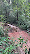
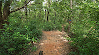
Photos of Mobile Mountain Bike
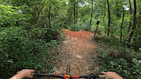
Videos of Mobile Mountain Bike
trail: Covid's Cure
0:13 |
|
Mar 3, 2023
trail: Upper Rip Current
0:14 |
193 |
Sep 22, 2022
trail: Upper Rip Current
0:06 |
88 |
Sep 22, 2022
trail: Slim Jim
0:46 |
|
Aug 13, 2022
trail: Upper Rip Current
0:19 |
|
Aug 13, 2022
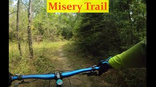
trail: Misery Trail
6:01 |
229 |
Aug 20, 2021 , Mobile
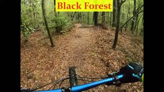
trail: Black Forest
7:40 |
277 |
Aug 20, 2021 , Mobile
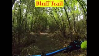
trail: Bluff Trail
7:42 |
204 |
Aug 20, 2021 , Mobile
Recent Trail Reports
| status | trail | date | condition | info | user |
|---|---|---|---|---|---|
| The Bottoms Long | Jan 1, 2025 @ 2:23pm Jan 1, 2025 | Ideal | pinteda | ||
| T T T | Jan 1, 2025 @ 2:23pm Jan 1, 2025 | Ideal | pinteda | ||
| Mike Thompson Loop | Jan 1, 2025 @ 2:23pm Jan 1, 2025 | Ideal | pinteda | ||
| Eric's Trail | Jan 1, 2025 @ 2:23pm Jan 1, 2025 | Ideal | pinteda | ||
| Red Rock | Jan 1, 2025 @ 2:23pm Jan 1, 2025 | Ideal | pinteda | ||
| Bottoms Start | Jan 1, 2025 @ 2:23pm Jan 1, 2025 | Ideal | pinteda | ||
| Dirt Don't Hurt | Jan 6, 2024 @ 10:47am Jan 6, 2024 | Ideal | QkzQWK | ||
| Covid's Cure | Jan 6, 2024 @ 10:43am Jan 6, 2024 | Ideal | QkzQWK | ||
| Slim Jim | Jun 9, 2023 @ 10:52pm Jun 9, 2023 | Ideal | WithMalles | ||
| Lil Chungus | Mar 24, 2023 @ 9:08am Mar 24, 2023 | Dry | empursley |
Activity Feed
| username | action | type | title | date |
|---|---|---|---|---|
| Kpreb71 | wishlist | badge | activity #97648116 and 1 more | Jun 23, 2026 @ 1:09pm 16 hours |
| Ken01ID1N | ridden | trail | activity #96665825 | Jun 10, 2026 @ 5:24am Jun 10, 2026 |
| steveStruck | wishlist | trail | activity #93726745 | Apr 30, 2026 @ 11:49am Apr 30, 2026 |
| HannaheEgPFs | wishlist | region | activity #92807414 | Apr 17, 2026 @ 1:06pm Apr 17, 2026 |
| workmant | wishlist | region | activity #91162742 | Mar 23, 2026 @ 1:23pm Mar 23, 2026 |
Recent Comments
| username | type | title | comment | date |
|---|---|---|---|---|
| trail | sick | Aug 22, 2023 @ 8:10am Aug 22, 2023 |
Local Badges
-

10 Green Trails44 awarded -

10 Blue Trails43 awarded -

Epic Ride Climb 2k0 awarded -

Climbing 10k Badge8 awarded -

Climbing 100k Badge0 awarded -

Epic Ride Descent 2k0 awarded
Bike & Skill Parks
| name | type | city | rating |
|---|---|---|---|
| Playground | skill park | Mobile | |
| Irvington Motorsports Park | skill park | Mobile |
Local Mountain Biking Directory
-
South Alabama Mountain Bike Association
![South Alabama Mountain Bike Association]()
-
Gulf Coast Composite Mountain Bike Team
![Gulf Coast Composite Mountain Bike Team]()
-
Cadence 120Bike Shop
-
All About BicyclesBike Shop
-
Cycle TherapyBike Shop
-
Adventure EarthBike Shop
Activity Type Stats
| activitytype | trails | distance | descent | descent distance | total vertical | rating | global rank | state rank | photos | reports | routes | ridelogs |
|---|---|---|---|---|---|---|---|---|---|---|---|---|
| Mountain Bike | 38 | 43 miles | 1,572 ft | 8 miles | 213 ft | #2,698 | #964 | 49 | 91 | 2 | 3,990 | |
| E-Bike | 20 | 9 miles | 410 ft | 2 miles | 154 ft | #5,322 | #1,649 | 51 | 2 | 36 | ||
| Hike | 34 | 42 miles | 1,316 ft | 8 miles | 213 ft | #5,025 | #1,771 | 79 | 39 | |||
| Trail Running | 34 | 42 miles | 1,316 ft | 8 miles | 213 ft | #4,564 | #1,412 | 79 | 115 |
Frequently Asked Questions About Mobile
▼
What are the best places to ride in Mobile?
Mobile has 4 areas to explore for mountain biking. The top rated areas are:
▼
What are the highest rated mountain biking trails in Mobile?
The highest rated mountain biking trails in Mobile are:
- Xcboy (4.3/5)
- Lower Rip Current (4.3/5)
- Covid's Cure (4.3/5)
- Dirt Don't Hurt (4.2/5)
- Slim Jim (4.2/5)
▼
What is the best time of the year to ride in Mobile?
Based on ride log data, the most popular months to ride in Mobile are:
- May (31 activities)
- June (24 activities)
- March (19 activities)
▼
Where can I park to ride in Mobile?
There are 4 parking locations listed in Mobile. The most popular parking spots are: View all parking and trailhead locations on the map to plan your visit.
Activities
Trails
- By brenthillier
 NSMBA TRAILFORKS & contributors
 - Admins: SAMBA
- #11241 - 7,634 views
- mobile activity log | embed map of Mobile mountain bike trails | mobile mountain biking points of interest
Downloading of trail gps tracks in kml & gpx formats is enabled for Mobile.
You must login to download files.