close
-
Layers w
- Weather Layers
- Pro
- Pro
- Pro
- Pro
- Pro
- Pro
- More Layers
- Pro
- Pro
- Pro
- Pro
-
Upgrade to

3D
Trail Conditions
- Unknown
- Snow Groomed
- Snow Packed
- Snow Covered
- Snow Cover Partial
- Freeze/thaw Cycle
- Icy
- Prevalent Mud
- Wet
- Variable
- Ideal
- Dry
- Very Dry
Trail Flow (Ridden Direction)
Trailforks scans users ridelogs to determine the most popular direction each trail is ridden. A good flowing trail network will have most trails flowing in a single direction according to their intension.
The colour categories are based on what percentage of riders are riding a trail in its intended direction.
The colour categories are based on what percentage of riders are riding a trail in its intended direction.
- > 96%
- > 90%
- > 80%
- > 70%
- > 50%
- < 50%
- bi-directional trail
- no data
Trail Last Ridden
Trailforks scans ridelogs to determine the last time a trail was ridden.
- < 2 days
- < 1 week
- < 2 weeks
- < 1 month
- < 6 months
- > 6 months
Trail Ridden Direction
The intended direction a trail should be ridden.
- Downhill Only
- Downhill Primary
- Both Directions
- Uphill Primary
- Uphill Only
- One Direction
Contribute Details
Colors indicate trail is missing specified detail.
- Description
- Photos
- Description & Photos
- Videos
Trail Popularity ?
Trailforks scans ridelogs to determine which trails are ridden the most in the last 9 months.
Trails are compared with nearby trails in the same city region with a possible 25 colour shades.
Think of this as a heatmap, more rides = more kinetic energy = warmer colors.
- most popular
- popular
- less popular
- not popular
ATV/ORV/OHV Filter
Max Vehicle Width
inches
US Cell Coverage
Legend

Radar Time
Activity Recordings
Trailforks uses anonymized public activity data.
?
Activity Recordings
Trailforks uses anonymized public activity data.
?
Personal Heatmap
▶
Activity Types
all
/
none
▶
Options
2
Date range
month
–
Winter Trails
Warning
A routing network for winter maps does not exist. Selecting trails using the winter trails layer has been disabled.
Missing Trails
Most Popular
Least Popular
Trails are colored based on popularity. The more popular a trail is, the more red. Less popular trails trend towards green.
Jump Magnitude Heatmap
Heatmap of where riders jump on trails. Zoom in to see individual jumps, click circles to view jump details.
BC Backroad Status
![map legend]()
Service Road Atlas is a free to use, community-driven service for viewing and creating reports on the numerous back-country service roads around B.C. and Alberta.

Slope Aspect
Direction the slope faces
Trails Deemphasized
Trails are shown in grey.
Only show trails with no bike usage.
Suggested Layers
Based on selected activity type
Save the current map location and zoom level as your default home location whenever this page is loaded.
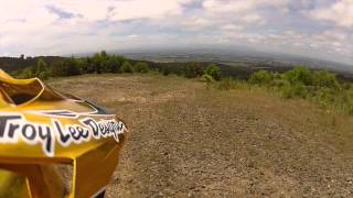
SaveMoe is one of the main mountain biking hubs in the Latrobe Valley. With the highlight being Haunted Hills Mountain Bike Park, a purpose-built network of trails with lots of flow and a range of trails ranging from beginner to advanced riders.\r\n\r\nTowards Moe Heights, Edward Hunter Heritage Bush Reserve offers shorter beginner-friendly loops and quick trails closer to town.\r\n\r\nFor more experienced riders, the Moe Pines has technical, old-school downhill trails.
View region descriptions for other activity types
Generic
Mountain Bike
Moe is one of the main mountain biking hubs in the Latrobe Valley. With the highlight being Haunted Hills Mountain Bike Park, a purpose-built network of trails with lots of flow and a range of trails ranging from beginner to advanced riders.\r\n\r\nTowards Moe Heights, Edward Hunter Heritage Bush Reserve offers shorter beginner-friendly loops and quick trails closer to town.\r\n\r\nFor more experienced riders, the Moe Pines has technical, old-school downhill trails. E-Bike
Moe is one of the main mountain biking hubs in the Latrobe Valley. With the highlight being Haunted Hills Mountain Bike Park, a purpose-built network of trails with lots of flow and a range of trails ranging from beginner to advanced riders.\r\n\r\nTowards Moe Heights, Edward Hunter Heritage Bush Reserve offers shorter beginner-friendly loops and quick trails closer to town.\r\n\r\nFor more experienced riders, the Moe Pines has technical, old-school downhill trails. Gravel Bike
Moe has a strong base of gravel riding from quiet farm laneways in the Strzelecki ranges to the rail trail between Moe and Yallourn or even the number of skinny roads in the valley floor. \r\n\r\nThe Moe - Yallourn Rail Trail provides a flat, scenic spin towards Yallourn W power station and Lake Narracan. Adaptive Bike
Adaptive riding is best supported in the Haunted Hills Mountain Bike Park due to the design of the trails and network. Trails are wider and smoother with more facilities to cater to adaptive riders. Horse
Horse riding can be done in surrounding forests and Edward Hunter Heritage Bush Reserve. Hike
Moe provides easy access to surrounding Gippsland national parks. Edward Hunter Heritage Bush Reserve has short and casual trails locally. Access is also provided towards Mt Baw Baw and Walhalla for more challenging terrain and longer hikes. Trail Running
Moe provides easy access to surrounding Gippsland national parks. Edward Hunter Heritage Bush Reserve has short and casual trails locally. Access is also provided towards Mt Baw Baw and Walhalla for more challenging terrain and longer runs. Dirtbike/Moto
The pine plantations and state forest areas surrounding Moe are popular among trail bike riders. These areas feature a mix of sandy trails, fire roads and technical terrain. Observed Trials
The pine plantations and state forest areas surrounding Moe are popular among trials riders. The mixture technical terrain and obstacles in these areas supports basic trials riding.Activities Click to view
- Mountain Bike
143 trails
- E-Bike
143 trails
- Gravel Bike
15 trails
- Adaptive Bike
26 trails
- Horse
28 trails
- Hike
77 trails
- Trail Running
76 trails
- Dirtbike/Moto
18 trails
- Observed Trials
4 trails
Region Details
- 14
- 2
- 49
- 37
- 17
- 6
Region Status
Caution as of 22 hoursStats
- Avg Trail Rating
- Trails (view details)
- 129
- Trails Mountain Bike
- 143
- Trails E-Bike
- 143
- Trails Gravel Bike
- 15
- Trails Adaptive Bike
- 26
- Trails Winter Fat Bike
- 15
- Trails Horse
- 28
- Trails Hike
- 77
- Trails Trail Running
- 76
- Trails Dirtbike/Moto
- 18
- Trails Observed Trials
- 4
- Trails ATV/ORV/OHV
- 9
- Trails Backcountry Ski
- 2
- Total Distance
- 62 miles
- Total Descent Distance
- 29 miles
- Total Descent
- 12,114 ft
- Total Vertical
- 5,591 ft
- Highest Trailhead
- 5,804 ft
- Reports
- 1,778
- Photos
- 310
- Ridden Counter
- 19,021
Sub Regions
-
Edward Hunter Heritage Bush Reserve
- 17
- 10
- 1
-
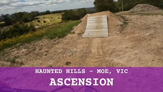
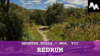
Haunted Hills Mountain Bike Park
- 1
- 22
- 13
- 10
-
Moe Pines
- 1
- 7
- 4
-
Moe-Yallourn Rail Trail
- 5
- 9
- 1
Popular Moe Mountain Biking Trails
• 100 ★ 4.6 • 476 ft • 0 ft • 1,368 •
Highly rated popular green difficulty family friendly asphalt/tarmac road. This mountain bike primary trail can be used one direction and has a easy overall physical rating with a 0 ft green climb. It features berm and pump track. Trail visibility is always easy to follow. On average it takes minutes to complete this trail.
• 100 ★ 4.2 • 778 ft • 0 ft • 752 •
A progressive descending flow trail for intermediate riders. Obstacles include tabletop jumps to increase the thrills. Mwah-hah-hah...
• 95 ★ 3.7 • 1,102 ft • 56 ft • 685 •
Easy climbing trail with a gentle gradient to take you to the top of Haunted Hills and between trail heads. Get ready to shred!
• 90 ★ 3.7 • 951 ft • 0 ft • 660 •
A difficult descent, like Dante's journey through Hell, with challenging features including jumpable rollers, gap jumps, step ups and big berms. Suitable for experienced riders.
• 90 ★ 4.4 • 804 ft • 0 ft • 637 •
Gradually increasing in wickedness, expect larger obstacles and features such as jumpable rollers with transitions, step downs, step ups and double jumps. Free yourself from sin.
• 100 ★ 4.5 • 2,694 ft • 3 ft • 634 •
Progressive descending trail that increases the rider’s ability to jump with confidence. Hollow sounds under hoof may cause cows to stampede and send beasts into the scrub.
• 100 ★ 3.4 • 1,588 ft • 64 ft • 625 •
An easy climb that will not keep you up all night but will take you top of the Haunted Hills via for more descending fun.
• 95 ★ 4.7 • 2,730 ft • 0 ft • 602 •
Fly or ride, make your choice. Witch way will you go? Unavoidable obstacles include large jumps, hips, step ups and downs, big berms, and shark fins. Suitable for experienced riders.
Moe Mountain Bike Routes
4 miles • 493 ft • 14 • Loop •
Proposed course for Round 7 of the Vic Series XCO
3 miles • 441 ft • 14 • Loop • Race •
The Shimano MTB GP’s events are all about ‘seriously fun racing’! Podium chasers can line up with...
Videos of Moe Mountain Bike
trail: Full Face (Upper)
4:14 |
31 |
Apr 1, 2026 , Moe

trail: Supercross DH
2:41 |
24 |
Apr 1, 2026 , Moe
youtuber
![Sunday Muddy Sunday, MTB Moe Pines.]()

trail: Supercross DH
8:19 |
27 |
Apr 1, 2026 , Moe
youtuber
![Haunted Hills Bike Park - Dante’s Descent]()

trail: Dante's Descent
0:37 |
97 |
Jan 3, 2026 , Moe
youtuber
![Haunted Hills Bike Park - Haunted Thrills]()
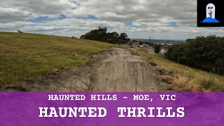
trail: Haunted Thrills
0:39 |
96 |
Jan 3, 2026 , Moe
youtuber
![Haunted Hills Bike Park - Last Rights]()

trail: Last Rights
0:39 |
69 |
Jan 3, 2026 , Moe
Current Trail Warnings
| status | trail | date | condition | user | info |
|---|---|---|---|---|---|
| Jumps to Bridge Link | Jun 12, 2026 @ 9:11pm (Australia/Melbourne) 22 hours | Variable | skipatrol01 | Very overgrown. Was only able to find... | |
| Dippers | Jun 12, 2026 @ 8:58pm (Australia/Melbourne) 22 hours | Variable | skipatrol01 | Well overgrown now. |
Recent Trail Reports
| status | trail | date | condition | info | user |
|---|---|---|---|---|---|
| Leonis Link | Jun 7, 2026 @ 7:02pm (Australia/Melbourne) Jun 7, 2026 | Variable | skipatrol01 | ||
| Supercross DH | May 25, 2026 @ 4:26pm (Australia/Melbourne) May 24, 2026 | Ideal | foxfraser MVP | ||
| Horsemen | May 25, 2026 @ 4:26pm (Australia/Melbourne) May 24, 2026 | Ideal | foxfraser MVP | ||
| Death Valley | May 25, 2026 @ 4:26pm (Australia/Melbourne) May 24, 2026 | Ideal | foxfraser MVP | ||
| Fools Errand | May 24, 2026 @ 4:27pm (Australia/Melbourne) May 23, 2026 | Ideal | foxfraser MVP | ||
| C150 Conveyor | May 24, 2026 @ 10:12am (Australia/Melbourne) May 23, 2026 | Unknown | Gsiinmaa HHBP | ||
| R.I.P | May 24, 2026 @ 10:08am (Australia/Melbourne) May 23, 2026 | Unknown | Gsiinmaa HHBP | ||
| Stakka | May 24, 2026 @ 10:06am (Australia/Melbourne) May 23, 2026 | Ideal | Gsiinmaa HHBP | ||
| Trick Or Treat | May 11, 2026 @ 11:32am (Australia/Melbourne) May 10, 2026 | Unknown | Gsiinmaa HHBP | ||
| Dammit | May 11, 2026 @ 11:27am (Australia/Melbourne) May 10, 2026 | Unknown | Gsiinmaa HHBP |
Activity Feed
| username | action | type | title | date |
|---|---|---|---|---|
| skipatrol01 | comment | trail | activity #96795740 | Jun 12, 2026 @ 5:09am 21 hours |
| skipatrol01 | vote | trail | activity #96795729 | Jun 12, 2026 @ 5:09am 21 hours |
| skipatrol01 | comment | trail | activity #96795698 | Jun 12, 2026 @ 5:09am 21 hours |
| skipatrol01 | vote | skillpark | activity #96795664 | Jun 12, 2026 @ 5:08am 21 hours |
| skipatrol01 | wishlist | skillpark | activity #96795658 | Jun 12, 2026 @ 5:08am 21 hours |
Recent Comments
| username | type | title | comment | date |
|---|---|---|---|---|
| trail | Very fun rail trail. | Jun 12, 2026 @ 5:09am 21 hours | ||
| trail | Don’t get mugged | Jun 12, 2026 @ 5:09am 21 hours | ||
| report | I didnt ride this one yesterday. Is it still... | Aug 22, 2025 @ 4:33pm Aug 22, 2025 | ||
| report | Great work mate. Rode it yesterday. | Aug 22, 2025 @ 4:31pm Aug 22, 2025 | ||
| report | Tech. Steep with switch backs and off camber... | Jun 28, 2025 @ 1:39pm Jun 28, 2025 |
Local Badges
-

HHBP Black Trails18 awarded -

HHBP Blue Trails157 awarded -

HHBP Green Trails64 awarded -

10 Green Trails256 awarded -

Top 10 Trails0 awarded -

Epic Ride 50k384 awarded
Bike & Skill Parks
| name | type | city | rating |
|---|---|---|---|
| Newborough BMX Track | skill park | Moe | |
| Moe Skate Park | skill park | Moe |
Local Trail Supporters
- Rail Trails Australia
Activity Type Stats
| activitytype | trails | distance | descent | descent distance | total vertical | rating | global rank | state rank | photos | reports | routes | ridelogs |
|---|---|---|---|---|---|---|---|---|---|---|---|---|
| Mountain Bike | 143 | 52 miles | 11,745 ft | 27 miles | 2,657 ft | #841 | #44 | 292 | 1,778 | 2 | 4,936 | |
| E-Bike | 143 | 60 miles | 11,775 ft | 28 miles | 3,442 ft | #669 | #55 | 18 | 1,771 | 1,070 | ||
| Gravel Bike | 15 | 2,805 ft | 299 ft | 2,254 ft | 295 ft | #346 | #110 | 3 | 2 | |||
| Adaptive Bike | 26 | 14 miles | 1,050 ft | 5 miles | 1,115 ft | #263 | #159 | 79 | ||||
| Winter Fat Bike | 15 | 9 miles | 594 ft | 4 miles | 272 ft | #57 | #79 | |||||
| Horse | 28 | 27 miles | 4,255 ft | 11 miles | 3,442 ft | #1,046 | #51 | 9 | ||||
| Hike | 77 | 39 miles | 6,214 ft | 18 miles | 3,442 ft | #4,360 | #126 | 187 | 108 | |||
| Trail Running | 76 | 39 miles | 6,207 ft | 17 miles | 3,442 ft | #3,738 | #112 | 187 | 4 | 203 | ||
| Dirtbike/Moto | 18 | 25 miles | 4,934 ft | 11 miles | 3,442 ft | #601 | #30 | 7 | 6 | |||
| Observed Trials | 4 | 1,532 ft | 10 ft | 722 ft | 23 ft | #159 | #4 | |||||
| ATV/ORV/OHV | 9 | 23 miles | 4,085 ft | 9 miles | 2,346 ft | #389 | #21 | 5 | ||||
| Backcountry Ski | 2 | 988 ft | 131 ft | #291 | #9 | 20 |
Frequently Asked Questions About Moe
▼
What are the best places to ride in Moe?
Moe has 6 areas to explore for mountain biking. The top rated areas are:
▼
What are the highest rated mountain biking trails in Moe?
The highest rated mountain biking trails in Moe are:
- Trick Or Treat (4.4/5)
- Pump Track (4.3/5)
- Mad Cows (4.3/5)
- Trumble (4.2/5)
- Electric Nightmare (4.2/5)
▼
What is the best time of the year to ride in Moe?
Based on ride log data, the most popular months to ride in Moe are:
- January (33 activities)
- December (30 activities)
- February (24 activities)
▼
Where can I park to ride in Moe?
There are 5 parking locations listed in Moe. The most popular parking spots are: View all parking and trailhead locations on the map to plan your visit.
Activities
Trails
- By gtrewern
 Gmtb & contributors
 - Admins: Victoria, Gmtb, MTBEG
- #12873 - 7,285 views
- moe activity log | embed map of Moe mountain bike trails | moe mountain biking points of interest polygons
Downloading of trail gps tracks in kml & gpx formats is enabled for Moe.
You must login to download files.