close
-
Layers w
- Weather Layers
- Pro
- Pro
- Pro
- Pro
- Pro
- Pro
- More Layers
- Pro
- Pro
- Pro
- Pro
-
Upgrade to

3D
Trail Conditions
- Unknown
- Snow Groomed
- Snow Packed
- Snow Covered
- Snow Cover Partial
- Freeze/thaw Cycle
- Icy
- Prevalent Mud
- Wet
- Variable
- Ideal
- Dry
- Very Dry
Trail Flow (Ridden Direction)
Trailforks scans users ridelogs to determine the most popular direction each trail is ridden. A good flowing trail network will have most trails flowing in a single direction according to their intension.
The colour categories are based on what percentage of riders are riding a trail in its intended direction.
The colour categories are based on what percentage of riders are riding a trail in its intended direction.
- > 96%
- > 90%
- > 80%
- > 70%
- > 50%
- < 50%
- bi-directional trail
- no data
Trail Last Ridden
Trailforks scans ridelogs to determine the last time a trail was ridden.
- < 2 days
- < 1 week
- < 2 weeks
- < 1 month
- < 6 months
- > 6 months
Trail Ridden Direction
The intended direction a trail should be ridden.
- Downhill Only
- Downhill Primary
- Both Directions
- Uphill Primary
- Uphill Only
- One Direction
Contribute Details
Colors indicate trail is missing specified detail.
- Description
- Photos
- Description & Photos
- Videos
Trail Popularity ?
Trailforks scans ridelogs to determine which trails are ridden the most in the last 9 months.
Trails are compared with nearby trails in the same city region with a possible 25 colour shades.
Think of this as a heatmap, more rides = more kinetic energy = warmer colors.
- most popular
- popular
- less popular
- not popular
ATV/ORV/OHV Filter
Max Vehicle Width
inches
US Cell Coverage
Legend

Radar Time
Activity Recordings
Trailforks uses anonymized public activity data.
?
Activity Recordings
Trailforks uses anonymized public activity data.
?
Personal Heatmap
▶
Activity Types
all
/
none
▶
Options
2
Date range
month
–
Winter Trails
Warning
A routing network for winter maps does not exist. Selecting trails using the winter trails layer has been disabled.
Missing Trails
Most Popular
Least Popular
Trails are colored based on popularity. The more popular a trail is, the more red. Less popular trails trend towards green.
Jump Magnitude Heatmap
Heatmap of where riders jump on trails. Zoom in to see individual jumps, click circles to view jump details.
BC Backroad Status
![map legend]()
Service Road Atlas is a free to use, community-driven service for viewing and creating reports on the numerous back-country service roads around B.C. and Alberta.

Slope Aspect
Direction the slope faces
Trails Deemphasized
Trails are shown in grey.
Only show trails with no bike usage.
Suggested Layers
Based on selected activity type
Save the current map location and zoom level as your default home location whenever this page is loaded.
Save
No description for Narvik has been added yet!
Login or register to submit one.
Primary Trail Type: All-Mountain & Downhill
Links
This region uses the Uk/Euro style trail grading system.
Activities Click to view
- Mountain Bike
72 trails
- E-Bike
30 trails
- Gravel Bike
23 trails
- Adaptive Bike
11 trails
- Winter Fat Bike
18 trails
- Hike
75 trails
- Trail Running
75 trails
- Nordic Ski
6 trails
Region Details
- 14
- 1
- 19
- 31
- 7
Region Status
Caution as of 2 hoursStats
- Avg Trail Rating
- Trails (view details)
- 77
- Trails Mountain Bike
- 72
- Trails E-Bike
- 30
- Trails Gravel Bike
- 23
- Trails Adaptive Bike
- 11
- Trails Winter Fat Bike
- 18
- Trails Horse
- 2
- Trails Hike
- 75
- Trails Trail Running
- 75
- Trails Backcountry Ski
- 2
- Trails Nordic Ski
- 6
- Total Distance
- 118 miles
- Total Descent
- 37,262 ft
- Total Vertical
- 3,065 ft
- Highest Trailhead
- 3,068 ft
- Reports
- 112
- Photos
- 169
- Ridden Counter
- 595
Sub Regions
-
Ballangen
-
Efjorden
-
Kjeldebotn
- 4
- 4
- 2
-
Narvik Skistua
- 4
- 7
- 3
-
Skarberget
-
Øyjord
- 4
- 9
Popular Narvik Mountain Biking Trails
• 75 ★ 5.0 • 10 miles • 1,948 ft • 41 •
Popular red difficulty alpine singletrack. This mountain bike primary trail and has a hard overall physical rating with a 1,948 ft blue climb. It features drop, jump, pump track, rock face, roller coaster, teeter totter and wallride. Trail visibility is sometimes hard to follow. On average it takes 3 hours51 minutes to complete this trail.
• 100 ★ 4.5 • 8 miles • 1,006 ft • 36 •
Rallarvägen från Björnefjell (Sverige) till Rombaksbotn (Norge). En riktigt härlig tur med fina vyer och bra cykling, en hel del höjdmeter om man ska tillbaka upp men med ebike är de inga problem. "I sommersesongen, fra og med 22....
• 90 ★ 5.0 • 3 miles • 81 ft • 19 •
Popular green difficulty singletrack. This mountain bike primary trail can be used downhill primary. On average it takes 33 minutes to complete this trail.
• 85 ★ 3.4 • 6 miles • 358 ft • 17 •
This is a classic route in both summer and winter. It got it´s name from people ending the route with a beer at Bjørnfjell station. Parts of it runs on old roads built by navvies at the turn of the 20th century (in part during WWII),...
• 90 ★ 0.0 • 2 miles • 1,276 ft • 15 •
Popular blue difficulty other. This mountain bike primary trail can be used both directions and has a hard overall physical rating with a 1,276 ft blue climb. It features drop, rock garden, roller coaster, wallride and other. On average it takes 2 hours7 minutes to complete this trail.
• 5 ★ 4.0 • 1 mile • 216 ft • 15 •
This is where the fun starts. There`s a lot of skinny´s over mudholes in the first and last part of the trail. If you´re not a pro at skinny´s this will give you and your friends a good laugh or two. Dont worry tho, you can walk...
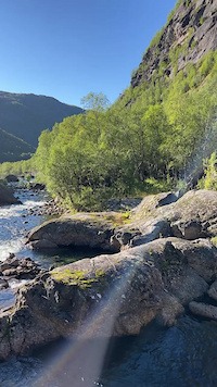
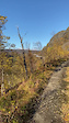
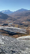
Photos of Narvik Mountain Bike
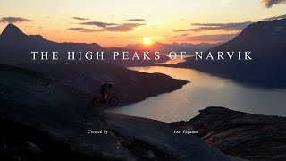
Videos of Narvik Mountain Bike
0:13 |
55 |
Sep 4, 2022
0:12 |
79 |
Jan 7, 2022
0:09 |
81 |
Jan 5, 2022
trail: Verdenssvadet
7:12 |
59 |
Sep 11, 2024 , Narvik

trail: Reinnesfjellet
7:12 |
136 |
Sep 11, 2024 , Narvik
trail: Verdenssvadet
5:22 |
266 |
Aug 2, 2024 , Narvik
trail: Reinnesfjellet
2:56 |
130 |
Apr 20, 2024 , Narvik
4:25 |
369 |
Aug 11, 2021 , Narvik
Current Trail Warnings
| status | trail | date | condition | user | info |
|---|---|---|---|---|---|
| Steinulf | Jun 28, 2026 @ 5:13pm (Europe/Oslo) 2 hours | Wet | Klerpa | Major Water drainage issue, large mud holes |
Recent Trail Reports
| status | trail | date | condition | info | user |
|---|---|---|---|---|---|
| LinkUp | Jun 28, 2026 @ 5:23pm (Europe/Oslo) 2 hours | Ideal | Klerpa | ||
| Odins Bue | Jun 28, 2026 @ 5:22pm (Europe/Oslo) 2 hours | Variable | Klerpa | ||
| Lian Downhill | Jun 28, 2026 @ 5:18pm (Europe/Oslo) 2 hours | Variable | Klerpa | ||
| Håfjelltuva Classic | Jun 28, 2026 @ 5:17pm (Europe/Oslo) 2 hours | Variable | Klerpa | ||
| Fonte del Capitano | May 30, 2026 @ 5:33pm (Europe/Vatican) May 30, 2026 | Ideal | reinera | ||
| Cemetery Uphill | Nov 23, 2025 @ 9:51am (Europe/Rome) Nov 23, 2025 | Ideal | MattiaCecchetti | ||
| Stora Ölturen | Jul 22, 2025 @ 6:57am Jul 22, 2025 | Snow Covered | Klerpa | ||
| Verdenssvadet | Jun 21, 2025 @ 12:20pm Jun 21, 2025 | Dry | chriguc | ||
| Skarbergflåget | Jul 29, 2024 @ 10:49am Jul 29, 2024 | Ideal | Klerpa | ||
| Heavenly Hellduro Till Katterat | Jul 29, 2024 @ 10:46am Jul 29, 2024 | Variable | Klerpa |
Activity Feed
| username | action | type | title | date |
|---|---|---|---|---|
| Klerpa | vote | trail | activity #97991159 and 2 more | Jun 28, 2026 @ 8:13am 2 hours |
| Klerpa | add | report | activity #97991136 and 4 more | Jun 28, 2026 @ 8:13am 2 hours |
| Klerpa | ridden | trail | activity #97819794 and 1 more | Jun 26, 2026 @ 12:42am 2 days |
| markkuyyGRZ9 | ridden | trail | activity #97794477 | Jun 25, 2026 @ 2:47pm 3 days |
| Klerpa | ridden | trail | activity #97786891 and 3 more | Jun 25, 2026 @ 12:41pm 3 days |
Recent Comments
| username | type | title | comment | date |
|---|---|---|---|---|
| trail | Super trail! | Jul 25, 2025 @ 11:19am Jul 25, 2025 | ||
| trail | Highly recommandable, fun ride with a lot of... | Jul 25, 2025 @ 11:12am Jul 25, 2025 | ||
| trail | absolutley worth the effort in dry conditions,... | Sep 11, 2022 @ 7:50am Sep 11, 2022 | ||
| trail | absolutely not worth the effort.. do not... | Jul 23, 2022 @ 6:19am Jul 23, 2022 | ||
| report | , ooxy | Jun 11, 2022 @ 4:12am Jun 11, 2022 |
Local Badges
-

10 Blue Trails1 awarded -

Epic Ride Climb 2k22 awarded -

Climbing 10k Badge3 awarded -

Climbing 100k Badge1 awarded -

Epic Ride Descent 2k35 awarded -

Descent 10k Badge3 awarded
Bike & Skill Parks
| name | type | city | rating |
|---|---|---|---|
| Ankenesfjellet Pumptrack | skill park | Narvik |
Local Trail Supporters
- Norrøna
Activity Type Stats
| activitytype | trails | distance | descent | descent distance | total vertical | rating | global rank | state rank | photos | reports | routes | ridelogs |
|---|---|---|---|---|---|---|---|---|---|---|---|---|
| Mountain Bike | 72 | 113 miles | 36,722 ft | 61 miles | 3,064 ft | #1,085 | #11 | 122 | 112 | 1,150 | ||
| E-Bike | 30 | 58 miles | 17,736 ft | 32 miles | 2,726 ft | #627 | #13 | 47 | 82 | 206 | ||
| Gravel Bike | 23 | 26 miles | 6,696 ft | 15 miles | 2,241 ft | #4,187 | #6 | 7 | 4 | |||
| Adaptive Bike | 11 | 24 miles | 7,139 ft | 16 miles | 2,251 ft | #4,196 | #14 | 11 | ||||
| Winter Fat Bike | 18 | 48 miles | 9,186 ft | 22 miles | 3,058 ft | #4,187 | #17 | 11 | 1 | |||
| Horse | 2 | 1 mile | 541 ft | 4,925 ft | 351 ft | 17 | ||||||
| Hike | 75 | 115 miles | 34,341 ft | 60 miles | 3,064 ft | #920 | #10 | 109 | 599 | |||
| Trail Running | 75 | 115 miles | 34,341 ft | 60 miles | 3,064 ft | #643 | #10 | 109 | 327 | |||
| Backcountry Ski | 2 | 3 miles | 75 ft | 1,293 ft | 1,555 ft | 1 | 285 | |||||
| Nordic Ski | 6 | 8 miles | 679 ft | 2 miles | 1,073 ft | #187 | #15 | 162 |
Frequently Asked Questions About Narvik
▼
What are the best places to ride in Narvik?
Narvik has 6 areas to explore for mountain biking. The top rated areas are:
▼
What are the highest rated mountain biking trails in Narvik?
The highest rated mountain biking trails in Narvik are:
- Reinnesfjellet (4.4/5)
- LinkUp (4.2/5)
- Sauen (4.2/5)
- Odins Bue (4.2/5)
- Katterat to Rallarveien connect (4.1/5)
▼
What is the best time of the year to ride in Narvik?
Based on ride log data, the most popular months to ride in Narvik are:
- July (37 activities)
- August (28 activities)
- June (24 activities)
▼
Where can I park to ride in Narvik?
There are 5 parking locations listed in Narvik. The most popular parking spots are:
- Parkering med minikraftverket (Spruten)
- Parking
- Veteranplassen
- Parkering ved Leirviktunnelen
- Langstranda
Activities
Trails
Points of Interest
- By Odegaard86 & contributors
- Admins: markstrom83
- #4574 - 10,306 views
- narvik activity log | embed map of Narvik mountain bike trails | narvik mountain biking points of interest
Downloading of trail gps tracks in kml & gpx formats is enabled for Narvik.
You must login to download files.