close
-
Layers w
- Weather Layers
- Pro
- Pro
- Pro
- Pro
- Pro
- Pro
- More Layers
- Pro
- Pro
- Pro
- Pro
-
Upgrade to

3D
Trail Conditions
- Unknown
- Snow Groomed
- Snow Packed
- Snow Covered
- Snow Cover Partial
- Freeze/thaw Cycle
- Icy
- Prevalent Mud
- Wet
- Variable
- Ideal
- Dry
- Very Dry
Trail Flow (Ridden Direction)
Trailforks scans users ridelogs to determine the most popular direction each trail is ridden. A good flowing trail network will have most trails flowing in a single direction according to their intension.
The colour categories are based on what percentage of riders are riding a trail in its intended direction.
The colour categories are based on what percentage of riders are riding a trail in its intended direction.
- > 96%
- > 90%
- > 80%
- > 70%
- > 50%
- < 50%
- bi-directional trail
- no data
Trail Last Ridden
Trailforks scans ridelogs to determine the last time a trail was ridden.
- < 2 days
- < 1 week
- < 2 weeks
- < 1 month
- < 6 months
- > 6 months
Trail Ridden Direction
The intended direction a trail should be ridden.
- Downhill Only
- Downhill Primary
- Both Directions
- Uphill Primary
- Uphill Only
- One Direction
Contribute Details
Colors indicate trail is missing specified detail.
- Description
- Photos
- Description & Photos
- Videos
Trail Popularity ?
Trailforks scans ridelogs to determine which trails are ridden the most in the last 9 months.
Trails are compared with nearby trails in the same city region with a possible 25 colour shades.
Think of this as a heatmap, more rides = more kinetic energy = warmer colors.
- most popular
- popular
- less popular
- not popular
ATV/ORV/OHV Filter
Max Vehicle Width
inches
US Cell Coverage
Legend

Radar Time
Activity Recordings
Trailforks uses anonymized public activity data.
?
Activity Recordings
Trailforks uses anonymized public activity data.
?
Personal Heatmap
▶
Activity Types
all
/
none
▶
Options
2
Date range
month
–
Winter Trails
Warning
A routing network for winter maps does not exist. Selecting trails using the winter trails layer has been disabled.
Missing Trails
Most Popular
Least Popular
Trails are colored based on popularity. The more popular a trail is, the more red. Less popular trails trend towards green.
Jump Magnitude Heatmap
Heatmap of where riders jump on trails. Zoom in to see individual jumps, click circles to view jump details.
BC Backroad Status
![map legend]()
Service Road Atlas is a free to use, community-driven service for viewing and creating reports on the numerous back-country service roads around B.C. and Alberta.

Slope Aspect
Direction the slope faces
Trails Deemphasized
Trails are shown in grey.
Only show trails with no bike usage.
Suggested Layers
Based on selected activity type
Save the current map location and zoom level as your default home location whenever this page is loaded.
Save
No description for Omis has been added yet!
Login or register to submit one.
This region uses the Uk/Euro style trail grading system.
Activities Click to view
- Mountain Bike
28 trails
- E-Bike
20 trails
- Adaptive Bike
0 trails
- Winter Fat Bike
0 trails
- Horse
5 trails
- Hike
26 trails
- Trail Running
27 trails
- Dirtbike/Moto
6 trails
- ATV/ORV/OHV
6 trails
Region Details
- 8
- 4
- 9
Region Status
Open as of Apr 30, 2026Stats
- Avg Trail Rating
- Trails (view details)
- 28
- Trails Mountain Bike
- 28
- Trails E-Bike
- 20
- Trails Horse
- 5
- Trails Hike
- 26
- Trails Trail Running
- 27
- Trails Dirtbike/Moto
- 6
- Trails ATV/ORV/OHV
- 6
- Total Distance
- 33 miles
- Total Descent
- 13,501 ft
- Total Vertical
- 2,437 ft
- Highest Trailhead
- 2,474 ft
- Reports
- 123
- Photos
- 110
- Ridden Counter
- 1,552
Sub Regions
-
Perun
- 2
- 5
Popular Omis Mountain Biking Trails
• 5 ★ 4.7 • 1,611 ft • 0 ft • 129 •
Begins as natural singletrack with the couple of small jumps leading into the roller coaster section with jumps and berms. Jumps are tabletops and doubles, riders can roll over them.
• 95 ★ 4.9 • 2,369 ft • 0 ft • 120 •
Twisty singletrack with typical Dalmatian combination of loose dirt and rocks. Has plenty of fun off-camber slip'n'slide sections.
• 90 ★ 4.4 • 1 mile • 32 ft • 106 •
Natural singletrack with variety of terrain, mostly loose dirt.
• 70 ★ 4.3 • 3,853 ft • 5 ft • 67 •
Beautiful trail through the pine woods. Part of it is groomed natural terrain, part of it is built features. It starts on the road and can be easily shuttled or pedalled to.
• 70 ★ 4.0 • 1 mile • 97 ft • 66 •
Rocky hiking path that's open enough to ride the bike on.
• 85 ★ 4.7 • 2,956 ft • 2 ft • 57 •
Rocky singletrack, partially reworked by the local trail builders. Has a couple of jumps, drops, steep chutes and rock gardens. Jumps, drops and chutes have chicken lines.
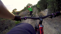
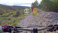
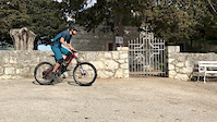
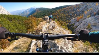
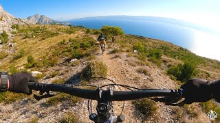
Photos of Omis Mountain Bike
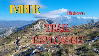
Videos of Omis Mountain Bike
trail: Viagra
2:07 |
378 |
Sep 18, 2018
trail: Viagra
2:13 |
283 |
Nov 15, 2017
trail: Lisicina
2:42 |
544 |
Apr 20, 2017

trail: StaroSelo_Gorica
14:06 |
183 |
Mar 8, 2022 , Omis
trail: Sv Vid Rogoznica DH
14:06 |
347 |
Mar 8, 2022 , Omis
trail: Imber
10:39 |
456 |
Dec 14, 2021 , Omis

trail: Sv Ivan
15:03 |
545 |
Nov 29, 2021 , Omis
trail: Ponor
15:03 |
574 |
Nov 29, 2021 , Omis
Recent Trail Reports
| status | trail | date | condition | info | user |
|---|---|---|---|---|---|
| Viagra | Apr 30, 2026 @ 6:21pm (Europe/Zagreb) Apr 30, 2026 | Dry | maja21 | ||
| Trusa | Apr 29, 2026 @ 10:40pm (Europe/Zagreb) Apr 29, 2026 | Variable | DanielWy2dJ4 | ||
| Stomorica | Apr 29, 2026 @ 10:39pm (Europe/Zagreb) Apr 29, 2026 | Ideal | DanielWy2dJ4 | ||
| Rocky Flow Stomorica | Apr 29, 2026 @ 10:38pm (Europe/Zagreb) Apr 29, 2026 | Ideal | DanielWy2dJ4 | ||
| Viper | Apr 29, 2026 @ 10:34pm (Europe/Zagreb) Apr 29, 2026 | Ideal | DanielWy2dJ4 | ||
| Dijagonala | Apr 29, 2026 @ 10:32pm (Europe/Zagreb) Apr 29, 2026 | Ideal | DanielWy2dJ4 | ||
| Ponor | Oct 7, 2025 @ 11:42am (Europe/Zagreb) Oct 7, 2025 | Dry | ckohlmeier | ||
| Sv Ivan | Oct 7, 2025 @ 11:42am (Europe/Zagreb) Oct 7, 2025 | Dry | ckohlmeier | ||
| Staro Selo Duce Access Road | Oct 7, 2025 @ 11:42am (Europe/Zagreb) Oct 7, 2025 | Ideal | ckohlmeier | ||
| Starsky & Hutch | Oct 8, 2025 @ 1:24pm (Europe/Zagreb) Oct 8, 2025 | Ideal | ckohlmeier |
Activity Feed
| username | action | type | title | date |
|---|---|---|---|---|
| BodzioiJZh6J | wishlist | trail | activity #95225237 | May 21, 2026 @ 11:29pm May 21, 2026 |
| notyoungnotalent | vote | trail | activity #94706066 | May 14, 2026 @ 12:28pm May 14, 2026 |
| maja21 | add | report | activity #93717561 | Apr 30, 2026 @ 9:21am Apr 30, 2026 |
| DanielWy2dJ4 | add | report | activity #93669270 and 4 more | Apr 29, 2026 @ 1:32pm Apr 29, 2026 |
| DanielWy2dJ4 | vote | trail | activity #93669211 and 4 more | Apr 29, 2026 @ 1:31pm Apr 29, 2026 |
Recent Comments
| username | type | title | comment | date |
|---|---|---|---|---|
| trail | Another awesome trail from coast riders! Some... | Oct 8, 2025 @ 10:11pm Oct 8, 2025 | ||
| trail | Legendary trail worth the push up! Views on... | Oct 8, 2025 @ 10:08pm Oct 8, 2025 | ||
| trail | Lovely climb up! One of the least intense... | Oct 7, 2025 @ 10:11am Oct 7, 2025 | ||
| trail | Another great trail in this zone. Optional... | Oct 7, 2025 @ 10:10am Oct 7, 2025 | ||
| trail | Good chunky downhill with some extra line... | Oct 7, 2025 @ 10:09am Oct 7, 2025 |
Local Badges
-

Epic Ride Climb 2k142 awarded -

Climbing 10k Badge28 awarded -

Climbing 100k Badge2 awarded -

Epic Ride Descent 2k169 awarded -

Descent 10k Badge32 awarded -

Descent 100k Badge2 awarded
Activity Type Stats
| activitytype | trails | distance | descent | descent distance | total vertical | rating | global rank | state rank | photos | reports | routes | ridelogs |
|---|---|---|---|---|---|---|---|---|---|---|---|---|
| Mountain Bike | 28 | 33 miles | 13,501 ft | 20 miles | 2,438 ft | #1,867 | #14 | 104 | 123 | 2,433 | ||
| E-Bike | 20 | 24 miles | 8,934 ft | 14 miles | 2,234 ft | #1,283 | #8 | 6 | 116 | 378 | ||
| Horse | 5 | 9 miles | 617 ft | 3 miles | 938 ft | #524 | #5 | 6 | ||||
| Hike | 26 | 33 miles | 13,163 ft | 20 miles | 2,438 ft | #1,933 | #14 | 124 | 252 | |||
| Trail Running | 27 | 33 miles | 13,501 ft | 20 miles | 2,438 ft | #1,448 | #13 | 124 | 45 | |||
| Dirtbike/Moto | 6 | 12 miles | 771 ft | 4 miles | 1,188 ft | #362 | #6 | 6 | ||||
| ATV/ORV/OHV | 6 | 11 miles | 751 ft | 4 miles | 938 ft | #249 | #6 | 6 | 2 |
Frequently Asked Questions About Omis
▼
What are the best places to ride in Omis?
Omis has 1 areas to explore for mountain biking. The top rated areas are:
▼
What are the highest rated mountain biking trails in Omis?
The highest rated mountain biking trails in Omis are:
- Viper (4.4/5)
- Imber (4.4/5)
- Dijagonala (4.4/5)
- Viagra (4.3/5)
- Sv Ivan (4.2/5)
▼
What is the best time of the year to ride in Omis?
Based on ride log data, the most popular months to ride in Omis are:
- July (14 activities)
- February (14 activities)
- June (13 activities)
▼
Where can I park to ride in Omis?
There are 1 parking locations listed in Omis. The most popular parking spots are:
Activities
Trails
Points of Interest
- By marincelo & contributors
- Admins: VjekoslavKrsanac
- #17777 - 15,283 views
- omis activity log | embed map of Omis mountain bike trails | omis mountain biking points of interest
Downloading of trail gps tracks in kml & gpx formats is enabled for Omis.
You must login to download files.