close
-
Layers w
- Weather Layers
- Pro
- Pro
- Pro
- Pro
- Pro
- Pro
- More Layers
- Pro
- Pro
- Pro
- Pro
-
Upgrade to

3D
Trail Conditions
- Unknown
- Snow Groomed
- Snow Packed
- Snow Covered
- Snow Cover Partial
- Freeze/thaw Cycle
- Icy
- Prevalent Mud
- Wet
- Variable
- Ideal
- Dry
- Very Dry
Trail Flow (Ridden Direction)
Trailforks scans users ridelogs to determine the most popular direction each trail is ridden. A good flowing trail network will have most trails flowing in a single direction according to their intension.
The colour categories are based on what percentage of riders are riding a trail in its intended direction.
The colour categories are based on what percentage of riders are riding a trail in its intended direction.
- > 96%
- > 90%
- > 80%
- > 70%
- > 50%
- < 50%
- bi-directional trail
- no data
Trail Last Ridden
Trailforks scans ridelogs to determine the last time a trail was ridden.
- < 2 days
- < 1 week
- < 2 weeks
- < 1 month
- < 6 months
- > 6 months
Trail Ridden Direction
The intended direction a trail should be ridden.
- Downhill Only
- Downhill Primary
- Both Directions
- Uphill Primary
- Uphill Only
- One Direction
Contribute Details
Colors indicate trail is missing specified detail.
- Description
- Photos
- Description & Photos
- Videos
Trail Popularity ?
Trailforks scans ridelogs to determine which trails are ridden the most in the last 9 months.
Trails are compared with nearby trails in the same city region with a possible 25 colour shades.
Think of this as a heatmap, more rides = more kinetic energy = warmer colors.
- most popular
- popular
- less popular
- not popular
ATV/ORV/OHV Filter
Max Vehicle Width
inches
US Cell Coverage
Legend

Radar Time
Activity Recordings
Trailforks uses anonymized public activity data.
?
Activity Recordings
Trailforks uses anonymized public activity data.
?
Personal Heatmap
▶
Activity Types
all
/
none
▶
Options
2
Date range
month
–
Winter Trails
Warning
A routing network for winter maps does not exist. Selecting trails using the winter trails layer has been disabled.
Missing Trails
Most Popular
Least Popular
Trails are colored based on popularity. The more popular a trail is, the more red. Less popular trails trend towards green.
Jump Magnitude Heatmap
Heatmap of where riders jump on trails. Zoom in to see individual jumps, click circles to view jump details.
BC Backroad Status
![map legend]()
Service Road Atlas is a free to use, community-driven service for viewing and creating reports on the numerous back-country service roads around B.C. and Alberta.

Slope Aspect
Direction the slope faces
Trails Deemphasized
Trails are shown in grey.
Only show trails with no bike usage.
Suggested Layers
Based on selected activity type
Save the current map location and zoom level as your default home location whenever this page is loaded.
Save
No description for Orem has been added yet!
Login or register to submit one.
Region Supporters & Maintainers
![]()
Utah Valley Trails AllianceSponsor
Activities Click to view
- Mountain Bike
133 trails
- E-Bike
86 trails
- Gravel Bike
8 trails
- Adaptive Bike
7 trails
- Horse
34 trails
- Hike
121 trails
- Trail Running
128 trails
- Dirtbike/Moto
13 trails
- ATV/ORV/OHV
7 trails
- Snowshoe
13 trails
Region Details
- 15
- 14
- 19
- 33
- 8
Region Status
Open as of Jun 2, 2026Stats
- Avg Trail Rating
- Trails (view details)
- 92
- Trails Mountain Bike
- 141
- Trails E-Bike
- 86
- Trails Gravel Bike
- 8
- Trails Adaptive Bike
- 7
- Trails Horse
- 34
- Trails Hike
- 122
- Trails Trail Running
- 128
- Trails Dirtbike/Moto
- 13
- Trails Observed Trials
- 2
- Trails ATV/ORV/OHV
- 7
- Trails Snowmobile
- 1
- Trails Snowshoe
- 13
- Trails Nordic Ski
- 1
- Total Distance
- 48 miles
- Total Descent
- 10,457 ft
- Total Vertical
- 3,364 ft
- Highest Trailhead
- 7,982 ft
- Reports
- 1,534
- Photos
- 317
- Ridden Counter
- 35,351
Sub Regions
-
Little Baldy Foothills
-
Orem Bike Park
-
Timpanogos State Wildlife Management Area
- 5
- 6
- 24
- 8
-
Utah Valley
- 2
- 3
- 3
Popular Orem Mountain Biking Trails
• 100 ★ 4.0 • 840 ft • 5 ft • 985 •
This is like a pump track but with enough descent that you can really get going fast. A couple small table tops allow more advanced riders to catch a little air. But most the track you just pump downhill for some fast fun.
• 100 ★ 4.2 • 1,024 ft • 36 ft • 983 •
Nice little flowy loop with some easy features to practice riding on. This is an excellent place to take kids and new riders. The trail winds through the trees, and there is one little rocky section, but very easy, just a taste. A easy...
• 100 ★ 4.0 • 456 ft • 0 ft • 860 •
This is the jewel in this little mountain bike park. The berms are sculpted and buff. Right off the rip you hit the first berm into a sender that sets you up for a nice little gap into a small rock garden. From there you it another big...
• 100 ★ 4.3 • 1,864 ft • 44 ft • 727 •
The includes a nice and easy climbing trail that is smooth with a nice gradient. In the middle where it is flat there a couple spots to jump, but you really have to pedal fast if you want to get any air. Once you finish the flat middle...
• 90 ★ 2.7 • 516 ft • 35 ft • 696 •
Love this little connector, just really short, before dumping you out to the flat, boring water tower road.
• 100 ★ 0.0 • 984 ft • 2 ft • 690 •
Trail starts along Murdock Pump Track and ends at Lindon Heritage Trail.
• 85 ★ 3.5 • 951 ft • 0 ft • 619 •
Excellent drop in from the Upper Race Course access trail. This trail will most likely become downhill only, until signage is up, I am setting it to Downhill Primary.
• 100 ★ 0.0 • 4,216 ft • 13 ft • 609 •
This is a multi-use path that used to be an old dirt road along the canal. Today it is one of the most popular places for families to safely cruise without worrying about cars. It is also a common connector to for mountain bikers to...
Orem Mountain Bike Routes
Battle Grove Epic Featured
15 miles • 3,386 ft • 8 • Loop •
This a an epic saturday ride that provides one of the easiest ways to get to the top of Grove Creek...
7 miles • 1,490 ft • 6 •
3 miles • 547 ft • 12 •
Nice warmup on Skill Lines prior to climbing up to do Loops
10 miles • 2,395 ft • 4 •
14 miles • 1,463 ft • 11 •
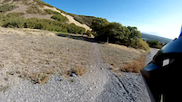
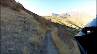
Photos of Orem Mountain Bike
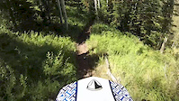
Videos of Orem Mountain Bike
trail: Black Line
0:05 |
174 |
Jul 10, 2021
trail: Gophersnake
4:56 |
114 |
Mar 21, 2015
trail: Little Baldy/Great Western
4:01 |
228 |
Mar 17, 2015
trail: Lament
3:44 |
140 |
Mar 17, 2015
11:09 |
127 |
Mar 16, 2015
trail: Aquila
0:01 |
372 |
Mar 5, 2015
trail: Moose Back
0:19 |
519 |
Jul 20, 2014

trail: Gophersnake
0:15 |
304 |
Mar 18, 2014
Recent Trail Reports
| status | trail | date | condition | info | user |
|---|---|---|---|---|---|
| Swift Ridge | May 29, 2026 @ 7:42am (America/Boise) May 29, 2026 | Ideal | timwhip | ||
| Bonneville Shoreline: Orem Trailhead | May 29, 2026 @ 7:42am (America/Boise) May 29, 2026 | Ideal | timwhip | ||
| Murdock Pump Track Trail | May 27, 2026 @ 12:58pm (America/Boise) May 27, 2026 | Ideal | walterrlaw | ||
| Sumac Hollow Lower | May 24, 2026 @ 10:44am (America/Boise) May 24, 2026 | Dry | walterrlaw | ||
| Dry Canyon Drive | May 24, 2026 @ 10:44am (America/Boise) May 24, 2026 | Ideal | walterrlaw | ||
| Indian Hills Bypass | May 20, 2026 @ 7:21pm (America/Boise) May 20, 2026 | Ideal | timwhip | ||
| Bramber | May 4, 2026 @ 4:39pm (America/Boise) May 4, 2026 | Ideal | timwhip | ||
| Groom | May 3, 2026 @ 11:52am (America/Boise) May 3, 2026 | Ideal | timwhip | ||
| Bee Line | May 3, 2026 @ 11:52am (America/Boise) May 3, 2026 | Ideal | timwhip | ||
| Race Access | May 3, 2026 @ 11:52am (America/Boise) May 3, 2026 | Ideal | timwhip |
National Scenic Trails & Official Routes
-
Bonneville Shoreline Trail
- Mountain Bike
- E-Bike
- Horse
- Hike
- Trail Running
- Snowshoe
- Nordic Ski
-
Great Western Trail
- Mountain Bike
- E-Bike
- Horse
- Hike
- Trail Running
- Dirtbike/Moto
- ATV/ORV/OHV


Activity Feed
| username | action | type | title | date |
|---|---|---|---|---|
| bplewe | update | trail | activity #96642505 and 12 more | Jun 9, 2026 @ 5:43pm 15 hours |
| bplewe | add | region | activity #96642403 | Jun 9, 2026 @ 5:41pm 15 hours |
| bplewe | update | skillpark | activity #96641947 | Jun 9, 2026 @ 5:34pm 15 hours |
| avidannie | add | polygon | activity #96641664 | Jun 9, 2026 @ 5:30pm 15 hours |
| avidannie | add | route | activity #96641005 and 5 more | Jun 9, 2026 @ 5:21pm 15 hours |
Recent Comments
| username | type | title | comment | date |
|---|---|---|---|---|
| trail | Super overgrown, hard to see the trail at... | Jul 31, 2025 @ 8:28pm Jul 31, 2025 | ||
| trail | Is now washed out again. Rocks n weeds... | Jun 3, 2025 @ 12:50pm Jun 3, 2025 | ||
| trail | Soft but not muddy. | Mar 10, 2025 @ 5:50pm Mar 10, 2025 | ||
| trail | Reopened in January 2025 | Feb 7, 2025 @ 2:31pm Feb 7, 2025 | ||
| trail | NOT open to ebikes! | Nov 3, 2024 @ 7:48am Nov 3, 2024 |
Local Badges
-

Completionist0 awarded -

Big Ride 30k2,845 awarded -

Epic Ride 50k580 awarded -

Top 10 Trails1 awarded -

Descent 100k Badge5 awarded -

10 Green Trails286 awarded
Bike & Skill Parks
| name | type | city | rating |
|---|---|---|---|
| Orem Bike - Skills Trails Park | skill park | Orem |
Local Mountain Biking Directory
-
Utah Valley Trails Alliance
![Utah Valley Trails Alliance]()
-
Utah Rocky Mountain Bikers
-
SBR Cycles
-
Urban Downfall CyclesBike Shop
-
Ratking BikesBike Shop
-
Mad Dog CyclesBike Shop
Activity Type Stats
| activitytype | trails | distance | descent | descent distance | total vertical | rating | global rank | state rank | photos | reports | routes | ridelogs |
|---|---|---|---|---|---|---|---|---|---|---|---|---|
| Mountain Bike | 133 | 44 miles | 8,881 ft | 20 miles | 3,363 ft | #724 | #280 | 333 | 1,598 | 24 | 29,209 | |
| E-Bike | 86 | 12 miles | 476 ft | 4 miles | 3,363 ft | #570 | #729 | 11 | 1,335 | 6 | 1,317 | |
| Gravel Bike | 8 | #390 | #438 | 1 | 37 | |||||||
| Adaptive Bike | 7 | #393 | #764 | 6 | 1 | |||||||
| Horse | 34 | 20 miles | 4,275 ft | 9 miles | 1,637 ft | #1,535 | #900 | 816 | ||||
| Hike | 121 | 48 miles | 10,427 ft | 22 miles | 3,363 ft | #1,082 | #497 | 9 | 1,605 | 8 | 1,724 | |
| Trail Running | 128 | 48 miles | 10,427 ft | 22 miles | 3,363 ft | #2,278 | #706 | 2 | 1,605 | 10 | 2,549 | |
| Dirtbike/Moto | 13 | 4,524 ft | 390 ft | #1,103 | #438 | 708 | 12 | |||||
| Observed Trials | 2 | 41 | 2 | |||||||||
| ATV/ORV/OHV | 7 | 4,524 ft | 390 ft | #808 | #359 | 707 | 6 | |||||
| Snowmobile | 1 | 4,524 ft | 390 ft | |||||||||
| Snowshoe | 13 | 11 miles | 935 ft | 3 miles | 3,064 ft | #857 | #400 | 61 | 5 | 20 | ||
| Nordic Ski | 1 | 3 |
Frequently Asked Questions About Orem
▼
What are the best places to ride in Orem?
Orem has 4 areas to explore for mountain biking. The top rated areas are:
▼
What are the highest rated mountain biking trails in Orem?
The highest rated mountain biking trails in Orem are:
- Aquila (4.4/5)
- Lament (4.2/5)
- Cottontail (4.1/5)
- Eye of the Tiger Loop (4.1/5)
- Gophersnake (4.1/5)
▼
What is the best time of the year to ride in Orem?
Based on ride log data, the most popular months to ride in Orem are:
- July (397 activities)
- June (263 activities)
- August (237 activities)
▼
Where can I park to ride in Orem?
There are 7 parking locations listed in Orem. The most popular parking spots are: View all parking and trailhead locations on the map to plan your visit.
Activities
Trails
- By canadaka
 Trailforks & contributors
 - Admins: jkwilliamz, UtahJohn, jpmcghee, jasonmalczyk, URMB, UVTA, URMB, UVTA
- #4736 - 13,736 views
- orem activity log | embed map of Orem mountain bike trails | orem mountain biking points of interest polygons
Downloading of trail gps tracks in kml & gpx formats is enabled for Orem.
You must login to download files.