close
-
Layers w
- Weather Layers
- Pro
- Pro
- Pro
- Pro
- Pro
- Pro
- More Layers
- Pro
- Pro
- Pro
- Pro
-
Upgrade to

3D
Trail Conditions
- Unknown
- Snow Groomed
- Snow Packed
- Snow Covered
- Snow Cover Partial
- Freeze/thaw Cycle
- Icy
- Prevalent Mud
- Wet
- Variable
- Ideal
- Dry
- Very Dry
Trail Flow (Ridden Direction)
Trailforks scans users ridelogs to determine the most popular direction each trail is ridden. A good flowing trail network will have most trails flowing in a single direction according to their intension.
The colour categories are based on what percentage of riders are riding a trail in its intended direction.
The colour categories are based on what percentage of riders are riding a trail in its intended direction.
- > 96%
- > 90%
- > 80%
- > 70%
- > 50%
- < 50%
- bi-directional trail
- no data
Trail Last Ridden
Trailforks scans ridelogs to determine the last time a trail was ridden.
- < 2 days
- < 1 week
- < 2 weeks
- < 1 month
- < 6 months
- > 6 months
Trail Ridden Direction
The intended direction a trail should be ridden.
- Downhill Only
- Downhill Primary
- Both Directions
- Uphill Primary
- Uphill Only
- One Direction
Contribute Details
Colors indicate trail is missing specified detail.
- Description
- Photos
- Description & Photos
- Videos
Trail Popularity ?
Trailforks scans ridelogs to determine which trails are ridden the most in the last 9 months.
Trails are compared with nearby trails in the same city region with a possible 25 colour shades.
Think of this as a heatmap, more rides = more kinetic energy = warmer colors.
- most popular
- popular
- less popular
- not popular
ATV/ORV/OHV Filter
Max Vehicle Width
inches
US Cell Coverage
Legend

Radar Time
Activity Recordings
Trailforks uses anonymized public activity data.
?
Activity Recordings
Trailforks uses anonymized public activity data.
?
Personal Heatmap
▶
Activity Types
all
/
none
▶
Options
2
Date range
month
–
Winter Trails
Warning
A routing network for winter maps does not exist. Selecting trails using the winter trails layer has been disabled.
Missing Trails
Most Popular
Least Popular
Trails are colored based on popularity. The more popular a trail is, the more red. Less popular trails trend towards green.
Jump Magnitude Heatmap
Heatmap of where riders jump on trails. Zoom in to see individual jumps, click circles to view jump details.
BC Backroad Status
![map legend]()
Service Road Atlas is a free to use, community-driven service for viewing and creating reports on the numerous back-country service roads around B.C. and Alberta.

Slope Aspect
Direction the slope faces
Trails Deemphasized
Trails are shown in grey.
Only show trails with no bike usage.
Suggested Layers
Based on selected activity type
Save the current map location and zoom level as your default home location whenever this page is loaded.
Save
No description for Otley has been added yet!
Login or register to submit one.
This region uses the Uk/Euro style trail grading system.
Activities Click to view
- Mountain Bike
45 trails
- E-Bike
36 trails
- Gravel Bike
0 trails
- Adaptive Bike
0 trails
- Winter Fat Bike
0 trails
- Horse
7 trails
- Hike
27 trails
- Trail Running
27 trails
Region Details
- 18
- 4
- 10
- 9
- 3
Region Status
Open as of May 7, 2026Stats
- Avg Trail Rating
- Trails (view details)
- 44
- Trails Mountain Bike
- 45
- Trails E-Bike
- 36
- Trails Horse
- 7
- Trails Hike
- 27
- Trails Trail Running
- 27
- Total Distance
- 14 miles
- Total Descent
- 3,988 ft
- Total Vertical
- 520 ft
- Highest Trailhead
- 901 ft
- Reports
- 56
- Photos
- 39
- Ridden Counter
- 3,401
Sub Regions
-
Otley Chevin Forest Park
- 4
- 10
- 9
- 3
-
Stainburn Forest
- 3
- 5
- 11
- 8
Popular Otley Mountain Biking Trails
• 100 ★ 3.6 • 1,480 ft • 86 ft • 485 •
A short, flowing single track loop through the trees returning through the recently clearfelled area with great views of the Washburn Valley.
• 90 ★ 4.1 • 2,943 ft • 0 ft • 471 •
A fast descent line which splits off from the red loop, joining up at the bottom of the hill with the black climb.
• 100 ★ 4.3 • 1,407 ft • 6 ft • 375 •
A short, flowing single track loop through the trees returning through the recently clearfelled area with great views of the Washburn Valley.
• 80 ★ 4.0 • 3,245 ft • 272 ft • 306 •
A short but challenging route. Narrow single track, rocky trails with varied surfaces passing through remote forest. Some very steep climbs, descents and technical obstacles and north shore sections.
• 90 ★ 4.5 • 1,568 ft • 9 ft • 246 •
Berms at the start with rocky sections to get over, goes into a pretty fast but technical well worn singletrack with drops before finishing in loamy steep conditions.
• 100 ★ 4.0 • 495 ft • 0 ft • 227 •
Popular red difficulty singletrack. This mountain bike primary trail can be used downhill only. It features rock garden. On average it takes 1 minutes to complete this trail.
• 90 ★ 3.7 • 2,113 ft • 0 ft • 222 • • hike
Tight fun descent to the top of the main descent line. Nice bit of loam in summer
• 95 ★ 2.5 • 128 ft • 0 ft • 220 •
A set of 3 different size side by side drops that allow the red loop to be sessioned, without the need to return to the car park start
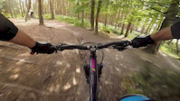
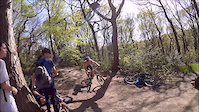
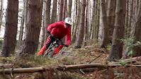
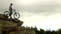
Photos of Otley Mountain Bike
Videos of Otley Mountain Bike
trail: Nothing but shorts
0:42 |
198 |
Aug 18, 2020
trail: Endor
0:20 |
217 |
Oct 10, 2018
trail: Warren Boulder Decent
2:18 |
1227 |
Aug 27, 2018
trail: The Descent Line
3:01 |
1042 |
Aug 27, 2018
trail: Stainburn Access Trail
10:16 |
183 |
Aug 12, 2018
trail: Endor
0:39 |
153 |
May 8, 2018
trail: Stainburn Access Trail
0:00 |
196 |
Jan 4, 2018
trail: Stainburn Access Trail
2:16 |
965 |
Oct 12, 2017
Recent Trail Reports
| status | trail | date | condition | info | user |
|---|---|---|---|---|---|
| Red Descent | May 7, 2026 @ 12:30pm (Europe/London) May 7, 2026 | Ideal | St-yx | ||
| Uncle Bruce's Ultimate Collection | Oct 18, 2025 @ 4:12pm (Europe/London) Oct 18, 2025 | Variable | JamesxRNbwE | ||
| Forest Road | Jul 3, 2025 @ 12:44pm Jul 3, 2025 | Ideal | boredbred | ||
| Warren Boulder Decent | Apr 29, 2025 @ 7:32am Apr 29, 2025 | Very Dry | jezsai Singletraction | ||
| Warren Boulder Ascent | Apr 29, 2025 @ 7:32am Apr 29, 2025 | Very Dry | jezsai Singletraction | ||
| The Descent Line | Apr 29, 2025 @ 7:32am Apr 29, 2025 | Very Dry | jezsai Singletraction | ||
| Red Ascent | Apr 29, 2025 @ 7:32am Apr 29, 2025 | Very Dry | jezsai Singletraction | ||
| Anything goes | Apr 29, 2025 @ 7:32am Apr 29, 2025 | Very Dry | jezsai Singletraction | ||
| Turnbull's Turns | Apr 15, 2025 @ 8:50am Apr 15, 2025 | Ideal | WillieJacobsz Trailforks | ||
| Tranquillity | Apr 15, 2025 @ 8:50am Apr 15, 2025 | Ideal | WillieJacobsz Trailforks |
Activity Feed
| username | action | type | title | date |
|---|---|---|---|---|
| St-yx | add | report | activity #94208451 | May 7, 2026 @ 4:30am May 7, 2026 |
| MTBDanB | ridden | trail | activity #92597420 and 6 more | Apr 14, 2026 @ 7:58am Apr 14, 2026 |
| dcwiddop | wishlist | region | activity #92542552 | Apr 13, 2026 @ 9:19am Apr 13, 2026 |
| petecouldwell | ridden | trail | activity #90663497 | Mar 15, 2026 @ 3:02pm Mar 15, 2026 |
| jezsai | update | region | activity #86465616 | Jan 1, 2026 @ 1:40pm Jan 1, 2026 |
Recent Comments
| username | type | title | comment | date |
|---|---|---|---|---|
| trail | Tricky | Apr 25, 2021 @ 1:37am Apr 25, 2021 |
Local Badges
-

Epic Ride Climb 2k14 awarded -

Climbing 10k Badge30 awarded -

Climbing 100k Badge2 awarded -

Epic Ride Descent 2k14 awarded -

Descent 10k Badge30 awarded -

Descent 100k Badge2 awarded
Bike & Skill Parks
| name | type | city | rating |
|---|---|---|---|
| Stainburn Pump Track | skill park | Otley |
Activity Type Stats
| activitytype | trails | distance | descent | descent distance | total vertical | rating | global rank | state rank | photos | reports | routes | ridelogs |
|---|---|---|---|---|---|---|---|---|---|---|---|---|
| Mountain Bike | 45 | 14 miles | 3,986 ft | 8 miles | 522 ft | #2,065 | #70 | 39 | 56 | 5,762 | ||
| E-Bike | 36 | 11 miles | 3,015 ft | 6 miles | 479 ft | #4,368 | #169 | 50 | 672 | |||
| Horse | 7 | 2 miles | 344 ft | 4,413 ft | 463 ft | #2,438 | #127 | 3 | ||||
| Hike | 27 | 11 miles | 2,369 ft | 6 miles | 522 ft | #8,369 | #252 | 49 | 472 | |||
| Trail Running | 27 | 11 miles | 2,369 ft | 6 miles | 522 ft | #7,996 | #244 | 49 | 291 |
Frequently Asked Questions About Otley
▼
What are the best places to ride in Otley?
Otley has 1 areas to explore for mountain biking. The top rated areas are:
▼
What are the highest rated mountain biking trails in Otley?
The highest rated mountain biking trails in Otley are:
- Warren Boulder Decent (4.3/5)
- Poisonous Snakes (4.2/5)
- Red Descent (4.1/5)
- Hunters Drop (4.1/5)
- Nothing but shorts (4.1/5)
▼
What is the best time of the year to ride in Otley?
Based on ride log data, the most popular months to ride in Otley are:
- July (26 activities)
- April (21 activities)
- February (9 activities)
▼
Where can I park to ride in Otley?
There are 7 parking locations listed in Otley. The most popular parking spots are: View all parking and trailhead locations on the map to plan your visit.
Activities
Trails
Points of Interest
- By wisey
 TRAILFORKS & contributors
 - Admins: wisey, MathieuC, cemoorelife
- #19588 - 2,645 views
- otley activity log | embed map of Otley mountain bike trails | otley mountain biking points of interest
Downloading of trail gps tracks in kml & gpx formats is enabled for Otley.
You must login to download files.