close
-
Layers w
- Weather Layers
- Pro
- Pro
- Pro
- Pro
- Pro
- Pro
- More Layers
- Pro
- Pro
- Pro
- Pro
-
Upgrade to

3D
Trail Conditions
- Unknown
- Snow Groomed
- Snow Packed
- Snow Covered
- Snow Cover Partial
- Freeze/thaw Cycle
- Icy
- Prevalent Mud
- Wet
- Variable
- Ideal
- Dry
- Very Dry
Trail Flow (Ridden Direction)
Trailforks scans users ridelogs to determine the most popular direction each trail is ridden. A good flowing trail network will have most trails flowing in a single direction according to their intension.
The colour categories are based on what percentage of riders are riding a trail in its intended direction.
The colour categories are based on what percentage of riders are riding a trail in its intended direction.
- > 96%
- > 90%
- > 80%
- > 70%
- > 50%
- < 50%
- bi-directional trail
- no data
Trail Last Ridden
Trailforks scans ridelogs to determine the last time a trail was ridden.
- < 2 days
- < 1 week
- < 2 weeks
- < 1 month
- < 6 months
- > 6 months
Trail Ridden Direction
The intended direction a trail should be ridden.
- Downhill Only
- Downhill Primary
- Both Directions
- Uphill Primary
- Uphill Only
- One Direction
Contribute Details
Colors indicate trail is missing specified detail.
- Description
- Photos
- Description & Photos
- Videos
Trail Popularity ?
Trailforks scans ridelogs to determine which trails are ridden the most in the last 9 months.
Trails are compared with nearby trails in the same city region with a possible 25 colour shades.
Think of this as a heatmap, more rides = more kinetic energy = warmer colors.
- most popular
- popular
- less popular
- not popular
ATV/ORV/OHV Filter
Max Vehicle Width
inches
US Cell Coverage
Legend

Radar Time
Activity Recordings
Trailforks uses anonymized public activity data.
?
Activity Recordings
Trailforks uses anonymized public activity data.
?
Personal Heatmap
▶
Activity Types
all
/
none
▶
Options
2
Date range
month
–
Winter Trails
Warning
A routing network for winter maps does not exist. Selecting trails using the winter trails layer has been disabled.
Missing Trails
Most Popular
Least Popular
Trails are colored based on popularity. The more popular a trail is, the more red. Less popular trails trend towards green.
Jump Magnitude Heatmap
Heatmap of where riders jump on trails. Zoom in to see individual jumps, click circles to view jump details.
BC Backroad Status
![map legend]()
Service Road Atlas is a free to use, community-driven service for viewing and creating reports on the numerous back-country service roads around B.C. and Alberta.

Slope Aspect
Direction the slope faces
Trails Deemphasized
Trails are shown in grey.
Only show trails with no bike usage.
Suggested Layers
Based on selected activity type
Save the current map location and zoom level as your default home location whenever this page is loaded.
Save
No description for Patras has been added yet!
Login or register to submit one.
Links
This region uses the Uk/Euro style trail grading system.
Activities Click to view
- Mountain Bike
27 trails
- E-Bike
24 trails
- Adaptive Bike
0 trails
- Hike
29 trails
- Trail Running
30 trails
Region Details
- 1
- 3
- 12
- 6
- 1
Region Status
Open as of Feb 1, 2026Local Trail Association
Stats
- Avg Trail Rating
- Trails (view details)
- 28
- Trails Mountain Bike
- 27
- Trails E-Bike
- 24
- Trails Horse
- 1
- Trails Hike
- 29
- Trails Trail Running
- 30
- Trails Dirtbike/Moto
- 1
- Trails Observed Trials
- 1
- Total Distance
- 15 miles
- Total Descent
- 8,738 ft
- Total Vertical
- 3,660 ft
- Highest Trailhead
- 3,887 ft
- Reports
- 60
- Photos
- 7
- Ridden Counter
- 271
Sub Regions
Popular Patras Mountain Biking Trails
• 95 ★ 4.3 • 2,825 ft • 0 ft • 16 •
Highly rated popular red difficulty singletrack. This multi-use trail can be used downhill primary with a 0 ft black diamond climb. It features berm, drop, log ride and rock garden. Adaptive MTB rating: amtb blue. Trail visibility is always easy to follow. On average it takes 7 minutes to complete this trail.
• 100 ★ 4.3 • 2,218 ft • 0 ft • 15 •
Popular blue difficulty singletrack. This mountain bike primary trail can be used both directions and has a moderate overall physical rating with a 0 ft blue climb. On average it takes 1 minutes to complete this trail.
• 85 ★ 4.5 • 1,614 ft • 2 ft • 15 •
Popular blue difficulty singletrack. This mountain bike primary trail can be used both directions with a 2 ft double black diamond climb. On average it takes 5 minutes to complete this trail.
• 65 ★ 5.0 • 1,821 ft • 12 ft • 12 •
Moderately popular blue difficulty singletrack. This multi-use trail can be used both directions and has a easy overall physical rating with a 12 ft green climb. On average it takes 3 minutes to complete this trail.
• 75 ★ 3.8 • 1,280 ft • 0 ft • 12 •
Popular red difficulty singletrack. This mountain bike primary trail can be used downhill only and has a moderate overall physical rating with a 0 ft blue climb. It features berm, drop and jump. Trail visibility is always easy to follow. On average it takes minutes to complete this trail.
• 60 ★ 5.0 • 1 mile • 18 ft • 9 •
The trail starts at the fireroad heading to the Monastery of Omblos. Around 500 before the monastery the trail starts heading down. In the end of the first section there is a steep wall that ends in the fireroad. The second part starts...
• 5 ★ 5.0 • 2,316 ft • 17 ft • 9 •
Less popular blue difficulty singletrack. This mountain bike primary trail can be used downhill only and has a moderate overall physical rating. It features berm, drop, jump, rock face and rock garden. Trail visibility is always easy to follow. On average it takes 5 minutes to complete this trail.
Patras Mountain Bike Routes
15 miles • 4,423 ft • 5 • Loop • Race •
Course map of the upcoming 2025 Achaia Enduro held in Patras.
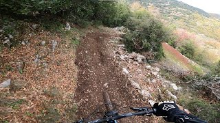
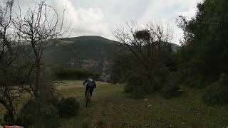
Videos of Patras Mountain Bike
trail: Antartiko tou Mitsou
0:16 |
298 |
Dec 19, 2020
trail: Founta Trail
0:34 |
195 |
Feb 2, 2022 , Patras
trail: Stavros Omplou
3:12 |
227 |
Feb 22, 2021 , Patras

trail: MoMa Forest
0:49 |
234 |
Dec 27, 2020 , Patras

trail: MoMa Forest
3:01 |
322 |
Dec 27, 2020 , Patras

trail: MoMa Forest
2:27 |
300 |
Dec 27, 2020 , Patras

trail: Γηροκομείο DH
0:22 |
315 |
Dec 27, 2020 , Patras

trail: Γηροκομείο DH
2:10 |
315 |
Dec 27, 2020 , Patras
Recent Trail Reports
| status | trail | date | condition | info | user |
|---|---|---|---|---|---|
| MoMa Forest | Feb 1, 2026 @ 6:35pm (Europe/Athens) Feb 1, 2026 | Ideal | LowerBassoon | ||
| Almata Moma | Oct 13, 2025 @ 6:19pm (Europe/Athens) Oct 13, 2025 | Wet | LowerBassoon | ||
| Shortcut Trail | Oct 13, 2025 @ 6:13pm (Europe/Athens) Oct 13, 2025 | Ideal | LowerBassoon | ||
| Three Peaks 2022 - LS1 | Nov 1, 2023 @ 5:51am Nov 1, 2023 | Ideal | antdiam PMBA | ||
| Kseropotamos | Jun 27, 2023 @ 7:13pm Jun 27, 2023 | Dry | antdiam PMBA | ||
| Betty the Partridge | Jun 27, 2023 @ 7:13pm Jun 27, 2023 | Dry | antdiam PMBA | ||
| Koumaria Trail | Oct 8, 2021 @ 10:09am Oct 8, 2021 | Ideal | antdiam PMBA | ||
| Tsakalakos | Feb 28, 2021 @ 8:47am Feb 28, 2021 | Dry | FilipposGrammenos | ||
| Γηροκομείο DH | Jan 23, 2021 @ 1:58am Jan 23, 2021 | Wet | antdiam PMBA | ||
| Ai Giorgis | Jan 8, 2021 @ 6:03am Jan 8, 2021 | Ideal | antdiam PMBA |
Activity Feed
| username | action | type | title | date |
|---|---|---|---|---|
| ankaratzas | wishlist | route | activity #93246216 | Apr 23, 2026 @ 4:14pm Apr 23, 2026 |
| LowerBassoon | add | report | activity #88162368 | Feb 1, 2026 @ 8:35am Feb 1, 2026 |
| bTqcuO | ridden | route | activity #84208010 | Nov 15, 2025 @ 2:44pm Nov 15, 2025 |
| Yannis7r31o | wishlist | route | activity #84157926 | Nov 15, 2025 @ 1:46am Nov 15, 2025 |
| JimmyKane | vote | trail | activity #84153886 | Nov 14, 2025 @ 10:04pm Nov 14, 2025 |
Recent Comments
| username | type | title | comment | date |
|---|---|---|---|---|
| trail | Start of the trail is covered with small to... | May 13, 2025 @ 9:10am May 13, 2025 | ||
| trail | Is fun to ride but also loose conditions | May 13, 2025 @ 9:07am May 13, 2025 | ||
| trail | Πολύ καλό για... | Aug 12, 2023 @ 6:15am Aug 12, 2023 | ||
| trail | Πολύ καλό για... | Aug 12, 2023 @ 6:15am Aug 12, 2023 | ||
| trail | Πολύ καλό για... | Aug 12, 2023 @ 6:15am Aug 12, 2023 |
Local Badges
-

Epic Mountain Bike Climb 2k14 awarded -

Climbing 10k Badge8 awarded -

Mountain Biking 100k Badge1 awarded -

Epic Ride Descent 2k14 awarded -

Descent 10k Badge9 awarded -

Descent 100k Badge1 awarded
Bike & Skill Parks
| name | type | city | rating |
|---|---|---|---|
| Patras Pump Track | skill park | Patras | |
| Dasyllio MTB spot | skill park | Patras |
Local Trail Supporters
- antdiam
![]()
Activity Type Stats
| activitytype | trails | distance | descent | descent distance | total vertical | rating | global rank | state rank | photos | reports | routes | ridelogs |
|---|---|---|---|---|---|---|---|---|---|---|---|---|
| Mountain Bike | 27 | 13 miles | 8,484 ft | 10 miles | 3,661 ft | #2,524 | #18 | 7 | 60 | 1 | 2,482 | |
| E-Bike | 24 | 10 miles | 6,122 ft | 7 miles | 3,661 ft | #1,299 | #8 | 53 | 1 | 41 | ||
| Horse | 1 | 1 mile | 52 ft | 797 ft | 620 ft | 9 | ||||||
| Hike | 29 | 15 miles | 8,737 ft | 10 miles | 3,661 ft | #1,981 | #12 | 59 | 1 | 75 | ||
| Trail Running | 30 | 15 miles | 8,737 ft | 10 miles | 3,661 ft | #1,477 | #10 | 59 | 1 | 267 | ||
| Dirtbike/Moto | 1 | 1 mile | 52 ft | 797 ft | 620 ft | 9 | ||||||
| Observed Trials | 1 | 614 ft | 52 ft | 3 |
Frequently Asked Questions About Patras
▼
What are the best places to ride in Patras?
Patras has 7 areas to explore for mountain biking. The top rated areas are:
▼
What are the highest rated mountain biking trails in Patras?
The highest rated mountain biking trails in Patras are:
- Koumaria Trail (4.3/5)
- On the Rocks (4.2/5)
- Betty the Partridge (4.2/5)
- Glaukos (4.2/5)
- Γηροκομείο DH (4.2/5)
▼
What is the best time of the year to ride in Patras?
Based on ride log data, the most popular months to ride in Patras are:
- August (1 activities)
▼
Where can I park to ride in Patras?
Check the Patras trail map for trailhead and parking information. Community members regularly update access and parking details for trails in the area.
Activities
Trails
Points of Interest
- By haristheodoropoulos
 HMBA TRAILFORKS & contributors
 - Admins: PMBA, antdiam
- #14225 - 6,422 views
- patras activity log | embed map of Patras mountain bike trails | patras mountain biking points of interest
Downloading of trail gps tracks in kml & gpx formats is enabled for Patras.
You must login to download files.