close
-
Layers w
- Weather Layers
- Pro
- Pro
- Pro
- Pro
- Pro
- Pro
- More Layers
- Pro
- Pro
- Pro
- Pro
-
Upgrade to

3D
Trail Conditions
- Unknown
- Snow Groomed
- Snow Packed
- Snow Covered
- Snow Cover Partial
- Freeze/thaw Cycle
- Icy
- Prevalent Mud
- Wet
- Variable
- Ideal
- Dry
- Very Dry
Trail Flow (Ridden Direction)
Trailforks scans users ridelogs to determine the most popular direction each trail is ridden. A good flowing trail network will have most trails flowing in a single direction according to their intension.
The colour categories are based on what percentage of riders are riding a trail in its intended direction.
The colour categories are based on what percentage of riders are riding a trail in its intended direction.
- > 96%
- > 90%
- > 80%
- > 70%
- > 50%
- < 50%
- bi-directional trail
- no data
Trail Last Ridden
Trailforks scans ridelogs to determine the last time a trail was ridden.
- < 2 days
- < 1 week
- < 2 weeks
- < 1 month
- < 6 months
- > 6 months
Trail Ridden Direction
The intended direction a trail should be ridden.
- Downhill Only
- Downhill Primary
- Both Directions
- Uphill Primary
- Uphill Only
- One Direction
Contribute Details
Colors indicate trail is missing specified detail.
- Description
- Photos
- Description & Photos
- Videos
Trail Popularity ?
Trailforks scans ridelogs to determine which trails are ridden the most in the last 9 months.
Trails are compared with nearby trails in the same city region with a possible 25 colour shades.
Think of this as a heatmap, more rides = more kinetic energy = warmer colors.
- most popular
- popular
- less popular
- not popular
ATV/ORV/OHV Filter
Max Vehicle Width
inches
US Cell Coverage
Legend

Radar Time
Activity Recordings
Trailforks uses anonymized public activity data.
?
Activity Recordings
Trailforks uses anonymized public activity data.
?
Personal Heatmap
▶
Activity Types
all
/
none
▶
Options
2
Date range
month
–
Winter Trails
Warning
A routing network for winter maps does not exist. Selecting trails using the winter trails layer has been disabled.
Missing Trails
Most Popular
Least Popular
Trails are colored based on popularity. The more popular a trail is, the more red. Less popular trails trend towards green.
Jump Magnitude Heatmap
Heatmap of where riders jump on trails. Zoom in to see individual jumps, click circles to view jump details.
BC Backroad Status
![map legend]()
Service Road Atlas is a free to use, community-driven service for viewing and creating reports on the numerous back-country service roads around B.C. and Alberta.

Slope Aspect
Direction the slope faces
Trails Deemphasized
Trails are shown in grey.
Only show trails with no bike usage.
Suggested Layers
Based on selected activity type
Save the current map location and zoom level as your default home location whenever this page is loaded.
Save
No description for Pfronten has been added yet!
Login or register to submit one.
This region uses the Uk/Euro style trail grading system.
Activities Click to view
- Mountain Bike
37 trails
- E-Bike
37 trails
- Adaptive Bike
0 trails
- Winter Fat Bike
0 trails
- Hike
36 trails
- Trail Running
36 trails
- Backcountry Ski
4 trails
Region Details
- 10
- 2
- 9
- 1
Region Status
Open as of May 17, 2026Stats
- Avg Trail Rating
- Trails (view details)
- 39
- Trails Mountain Bike
- 37
- Trails E-Bike
- 37
- Trails Hike
- 36
- Trails Trail Running
- 36
- Trails Backcountry Ski
- 4
- Total Distance
- 49 miles
- Total Descent
- 23,199 ft
- Total Vertical
- 3,210 ft
- Highest Trailhead
- 5,987 ft
- Reports
- 196
- Photos
- 71
- Ridden Counter
- 1,157
Sub Regions
-
Pfronten-Nesselwang
- 3
Popular Pfronten Mountain Biking Trails
• 55 ★ 4.7 • 5,112 ft • 0 ft • 53 •
Pedally and usually moist trail through the woods. Top section is harder than the rest, so don't let that scare you off.
• 85 ★ 5.0 • 5,177 ft • 0 ft • 40 •
Fun downhill on a popular MTB trail, consistently steep and technical. After a short climb on a double track at the top, the trail continues as a winding path through the woods. From there, the surface is mainly made up by soft forest...
• 100 ★ 4.5 • 2,474 ft • 0 ft • 39 •
Upper half of the trail leading to Kappel. Flowy downhill with very soft dirt and a few roots (existing trail will be cropped so it doesn't overlap)
• 40 ★ 2.4 • 1 mile • 38 ft • 32 •
Moderately popular green difficulty mixed. This multi-use trail can be used downhill primary and has a easy overall physical rating. Trail visibility is always easy to follow. On average it takes 7 minutes to complete this trail.
• 60 ★ 4.2 • 2,768 ft • 0 ft • 25 •
Very Steep and Difficult Trail hence its a primary Hiking Trail Uphill, very narrow rutted Switchbacks at the top (little room for your cranks), you'll need advanced bike handling skills to not walk the first 50m. Its not dangerous but...
Pfronten Mountain Bike Routes
19 miles • 6,764 ft • 6 • Point to Point •
Physical route for experienced riders. Requires pushing and carrying.
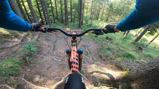
Photos of Pfronten Mountain Bike
Videos of Pfronten Mountain Bike
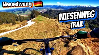
trail: Wiesenweg
14:49 |
112 |
Apr 15, 2025 , Pfronten
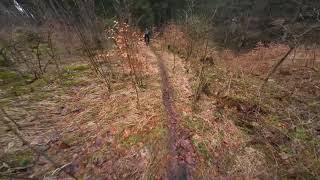
trail: Manzenköpfl
3:59 |
166 |
Mar 18, 2024 , Pfronten

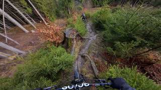
trail: Winkel Trail
6:34 |
161 |
Mar 18, 2024 , Pfronten
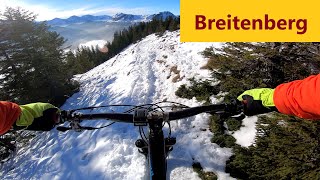
trail: Upper Ab nach Kappel
6:34 |
281 |
Mar 18, 2024 , Pfronten
trail: Umschlag
4:03 |
696 |
Jan 8, 2021 , Pfronten
trail: Kessa Trail
6:15 |
748 |
Sep 15, 2020 , Pfronten
Recent Trail Reports
| status | trail | date | condition | info | user |
|---|---|---|---|---|---|
| Wiesenweg | May 17, 2026 @ 5:21pm (Europe/Berlin) May 17, 2026 | Wet | shopsclose | ||
| Stubental | Nov 8, 2025 @ 11:38am (Europe/Vaduz) Nov 8, 2025 | Variable | Wurzelbernd | ||
| Lower Ab nach Kappel | Sep 21, 2025 @ 10:06am (Europe/Berlin) Sep 21, 2025 | Ideal | QucayN | ||
| Upper Ab nach Kappel | Sep 21, 2025 @ 10:06am (Europe/Berlin) Sep 21, 2025 | Ideal | QucayN | ||
| The Unremarkable Forest Road With A Jump | Sep 21, 2025 @ 10:06am (Europe/Berlin) Sep 21, 2025 | Ideal | QucayN | ||
| Edelsberg Access | Jun 23, 2025 @ 12:40pm Jun 23, 2025 | Ideal | Rabuntzel | ||
| Winkel Trail | Nov 4, 2024 @ 12:20pm Nov 4, 2024 | Variable | Wurzelbernd | ||
| Schönoibweg | Jun 30, 2024 @ 9:53am Jun 30, 2024 | Variable | Ludwig84 | ||
| Manzengrattrail | Oct 17, 2023 @ 3:35am Oct 17, 2023 | Variable | Benni23186 | ||
| Follow the Flow | Sep 29, 2023 @ 2:31pm Sep 29, 2023 | Dry | JohSch |
Activity Feed
| username | action | type | title | date |
|---|---|---|---|---|
| burninstreet | wishlist | trail | activity #96526092 | Jun 8, 2026 @ 1:20am Jun 8, 2026 |
| Puxzl | ridden | trail | activity #95765795 | May 29, 2026 @ 3:51am May 29, 2026 |
| KalkhoffKiller | wishlist | trail | activity #95759653 | May 28, 2026 @ 11:51pm May 28, 2026 |
| KalkhoffKiller | wishlist | trail | activity #95719519 | May 28, 2026 @ 10:58am May 28, 2026 |
| shopsclose | add | report | activity #94905536 | May 17, 2026 @ 8:22am May 17, 2026 |
Recent Comments
| username | type | title | comment | date |
|---|---|---|---|---|
| trail | One of the most underrated trails in the area... | Aug 26, 2025 @ 3:35am Aug 26, 2025 | ||
| trail | As mentioned before, the top part from... | Aug 25, 2025 @ 1:32pm Aug 25, 2025 | ||
| report | As mentioned before, the top part from... | Aug 25, 2025 @ 1:30pm Aug 25, 2025 | ||
| trail | Well, I think there are lots of different... | Jul 25, 2025 @ 2:49pm Jul 25, 2025 | ||
| trail | Realitycheck: 1.This is simply not a... | Jul 25, 2025 @ 2:36pm Jul 25, 2025 |
Local Badges
-

Epic Ride Climb 2k44 awarded -

Climbing 10k Badge12 awarded -

Climbing 100k Badge1 awarded -

Epic Ride Descent 2k44 awarded -

Descent 10k Badge12 awarded -

Descent 100k Badge1 awarded
Activity Type Stats
| activitytype | trails | distance | descent | descent distance | total vertical | rating | global rank | state rank | photos | reports | routes | ridelogs |
|---|---|---|---|---|---|---|---|---|---|---|---|---|
| Mountain Bike | 37 | 37 miles | 19,557 ft | 19 miles | 3,196 ft | #3,338 | #41 | 71 | 196 | 2 | 1,711 | |
| E-Bike | 37 | 3 miles | 13 ft | 709 ft | 1,578 ft | #4,672 | #143 | 84 | 520 | |||
| Hike | 36 | 36 miles | 18,038 ft | 18 miles | 3,196 ft | #4,654 | #41 | 187 | 634 | |||
| Trail Running | 36 | 36 miles | 18,478 ft | 18 miles | 3,196 ft | #951 | #14 | 188 | 167 | |||
| Backcountry Ski | 4 | 12 miles | 3,642 ft | 5 miles | 3,189 ft | #132 | #3 | 149 |
Frequently Asked Questions About Pfronten
▼
What are the best places to ride in Pfronten?
Pfronten has 1 areas to explore for mountain biking. The top rated areas are:
▼
What are the highest rated mountain biking trails in Pfronten?
The highest rated mountain biking trails in Pfronten are:
- Schönoibweg (4.5/5)
- Lower Ab nach Kappel (4.4/5)
- Stubental (4.4/5)
- Follow the Flow (4.3/5)
- Manzengrattrail (4.3/5)
▼
What is the best time of the year to ride in Pfronten?
Based on ride log data, the most popular months to ride in Pfronten are:
- June (14 activities)
- September (10 activities)
- July (10 activities)
▼
Where can I park to ride in Pfronten?
Check the Pfronten trail map for trailhead and parking information. Community members regularly update access and parking details for trails in the area.
Activities
Trails
- By granit & contributors
- Admins: larry81541
- #22684 - 4,495 views
- pfronten activity log | embed map of Pfronten mountain bike trails |
Downloading of trail gps tracks in kml & gpx formats is enabled for Pfronten.
You must login to download files.