close
-
Layers w
- Weather Layers
- Pro
- Pro
- Pro
- Pro
- Pro
- Pro
- More Layers
- Pro
- Pro
- Pro
- Pro
-
Upgrade to

3D
Trail Conditions
- Unknown
- Snow Groomed
- Snow Packed
- Snow Covered
- Snow Cover Partial
- Freeze/thaw Cycle
- Icy
- Prevalent Mud
- Wet
- Variable
- Ideal
- Dry
- Very Dry
Trail Flow (Ridden Direction)
Trailforks scans users ridelogs to determine the most popular direction each trail is ridden. A good flowing trail network will have most trails flowing in a single direction according to their intension.
The colour categories are based on what percentage of riders are riding a trail in its intended direction.
The colour categories are based on what percentage of riders are riding a trail in its intended direction.
- > 96%
- > 90%
- > 80%
- > 70%
- > 50%
- < 50%
- bi-directional trail
- no data
Trail Last Ridden
Trailforks scans ridelogs to determine the last time a trail was ridden.
- < 2 days
- < 1 week
- < 2 weeks
- < 1 month
- < 6 months
- > 6 months
Trail Ridden Direction
The intended direction a trail should be ridden.
- Downhill Only
- Downhill Primary
- Both Directions
- Uphill Primary
- Uphill Only
- One Direction
Contribute Details
Colors indicate trail is missing specified detail.
- Description
- Photos
- Description & Photos
- Videos
Trail Popularity ?
Trailforks scans ridelogs to determine which trails are ridden the most in the last 9 months.
Trails are compared with nearby trails in the same city region with a possible 25 colour shades.
Think of this as a heatmap, more rides = more kinetic energy = warmer colors.
- most popular
- popular
- less popular
- not popular
ATV/ORV/OHV Filter
Max Vehicle Width
inches
US Cell Coverage
Legend

Radar Time
Activity Recordings
Trailforks uses anonymized public activity data.
?
Activity Recordings
Trailforks uses anonymized public activity data.
?
Personal Heatmap
▶
Activity Types
all
/
none
▶
Options
2
Date range
month
–
Winter Trails
Warning
A routing network for winter maps does not exist. Selecting trails using the winter trails layer has been disabled.
Missing Trails
Most Popular
Least Popular
Trails are colored based on popularity. The more popular a trail is, the more red. Less popular trails trend towards green.
Jump Magnitude Heatmap
Heatmap of where riders jump on trails. Zoom in to see individual jumps, click circles to view jump details.
BC Backroad Status
![map legend]()
Service Road Atlas is a free to use, community-driven service for viewing and creating reports on the numerous back-country service roads around B.C. and Alberta.

Slope Aspect
Direction the slope faces
Trails Deemphasized
Trails are shown in grey.
Only show trails with no bike usage.
Suggested Layers
Based on selected activity type
Save the current map location and zoom level as your default home location whenever this page is loaded.
Save
No description for Pine has been added yet!
Login or register to submit one.
Activities Click to view
- Mountain Bike
50 trails
- E-Bike
9 trails
- Gravel Bike
0 trails
- Adaptive Bike
- Horse
20 trails
- Hike
65 trails
- Trail Running
53 trails
Region Details
- 18
- 4
- 16
- 4
- 6
Region Status
Open as of 2 daysStats
- Avg Trail Rating
- Trails (view details)
- 69
- Trails Mountain Bike
- 50
- Trails E-Bike
- 9
- Trails Horse
- 20
- Trails Hike
- 65
- Trails Trail Running
- 53
- Trails Dirtbike/Moto
- 1
- Total Distance
- 188 miles
- Total Descent
- 18,493 ft
- Total Vertical
- 3,569 ft
- Highest Trailhead
- 7,928 ft
- Reports
- 245
- Photos
- 200
- Ridden Counter
- 1,463
Sub Regions
-
Pine Strawberry Trail System
- 3
- 12
- 2
- 1
Popular Pine Mountain Biking Trails
• 95 ★ 4.0 • 3,533 ft • 8 ft • 212 •
Popular blue difficulty singletrack. This multi-use trail can be used downhill primary and has a moderate overall physical rating with a 8 ft blue climb. Trail visibility is always easy to follow. On average it takes 3 minutes to complete this trail.
• 95 ★ 3.9 • 4 miles • 399 ft • 188 •
Trail 15 is part of the Fire On The Rim mountain bike race that is held each September. This track is challenging but with the improvements the local trail crew has made over the past few years most of the heinous sections have been...
• 85 ★ 3.3 • 6 miles • 775 ft • 172 •
Excellent, well-designed singletrack and beautiful scenery the entire way. Although the trail is only moderate from a technical standpoint, it can be physically demanding in either direction due to a number of short but steep climbs and...
• 100 ★ 4.0 • 3,507 ft • 163 ft • 124 •
This segment of the near the Pine trailhead used to be part of the Arizona Trail until a recent reroute of the AZT. It now makes a nice short loop out of the Pine trailhead and is part of the AZT connector trail system
• 85 ★ 4.5 • 1 mile • 127 ft • 117 •
Popular blue difficulty singletrack. This multi-use trail can be used both directions and has a moderate overall physical rating with a 127 ft blue climb. Trail visibility is always easy to follow. On average it takes 8 minutes to complete this trail.
• 80 ★ 4.0 • 21 miles • 3,156 ft • 111 •
Trail has been re-routed and is now a great backcountry XC trail.
• 90 ★ 0.0 • 1,552 ft • 105 ft • 93 •
Popular blue difficulty singletrack. This multi-use trail can be used both directions and has a moderate overall physical rating with a 105 ft blue climb. Trail visibility is always easy to follow. On average it takes 3 minutes to complete this trail.
• 85 ★ 3.0 • 9 miles • 1,688 ft • 86 •
This is a great trail and it's getting better, there has been some trail work and there is more to come. I have only ridden it from the North (from tr) to south to the head off of 87. Coming from you'll see a sign marked Drippings...
Pine Mountain Bike Routes
37 miles • 4,414 ft • 2 • Loop •
Arizona Endurance Series Mogollon Mayhem Big Loop
18 miles • 2,028 ft • 1 • Race •
Annual Fire on the Rim mountain bike race in Pine, AZ.
Photos of Pine Mountain Bike
Videos of Pine Mountain Bike
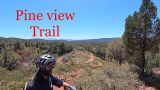
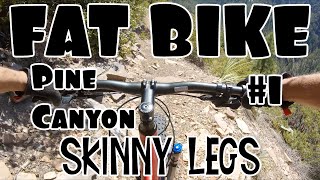
trail: Pine Canyon Trail (Blue)
20:30 |
98 |
Apr 26, 2025 , Pine
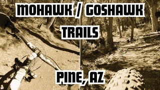
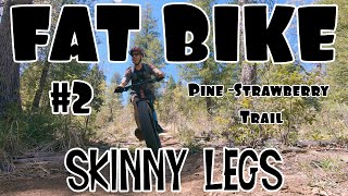
trail: Mohawk
6:42 |
82 |
Dec 8, 2024 , Pine
youtuber
![2021 Fire on the Rim Course Preview | Mountain...]()
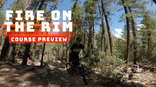
trail: Pine-Strawberry Trail
11:42 |
281 |
Jun 30, 2024 , Pine
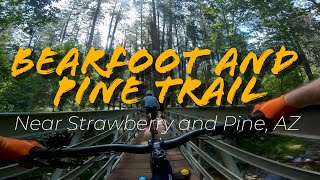
youtuber
![Follow Cam on the Rim | Bearfoot and Pine...]()
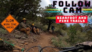
trail: Bearfoot Trail
13:41 |
136 |
Jun 30, 2024 , Pine
youtuber
![Follow Cam on the Rim | Bearfoot and Pine...]()

trail: Pine Canyon Trail (Blue)
13:41 |
177 |
Jun 30, 2024 , Pine
youtuber
![Best trail on the Rim? | Bearfoot and Pine...]()
trail: Pine Canyon Trail (Blue)
17:09 |
159 |
Jun 30, 2024 , Pine
trail: Mohawk
6:24 |
157 |
Mar 8, 2023 , Pine
10:00 |
506 |
May 21, 2021 , Pine
Recent Trail Reports
| status | trail | date | condition | info | user |
|---|---|---|---|---|---|
| Pine Canyon Trail (Blue) | Jun 2, 2026 @ 5:10pm (America/Phoenix) 2 days | Unknown | katanablues | ||
| Pine-Strawberry Trail | May 23, 2026 @ 3:27pm (America/Phoenix) May 23, 2026 | Unknown | TommyvqEusr | ||
| Two Ravens Trail | May 23, 2026 @ 11:54am (America/Phoenix) May 23, 2026 | Ideal | 1bigwave | ||
| Bearfoot Trail | May 15, 2026 @ 11:26am (America/Phoenix) May 15, 2026 | Unknown | katanablues | ||
| Mohawk | Apr 9, 2026 @ 5:50pm (America/Phoenix) Apr 9, 2026 | Ideal | tcreighton RCMBA | ||
| Tunnel Trail Spur | Sep 12, 2025 @ 11:22am (America/Phoenix) Sep 12, 2025 | Ideal | BikenBark | ||
| AZT - Col Devin Trail | Sep 12, 2025 @ 11:22am (America/Phoenix) Sep 12, 2025 | Ideal | BikenBark | ||
| Walnut Trail | Sep 1, 2025 @ 10:21pm Sep 1, 2025 | Unknown | seanfromhb | ||
| Lower Pineview Trail | Jul 5, 2025 @ 9:41am Jul 5, 2025 | Ideal | gravityjunkiepr | ||
| Pineview Trail | Jul 5, 2025 @ 9:41am Jul 5, 2025 | Ideal | gravityjunkiepr |
Activity Feed
| username | action | type | title | date |
|---|---|---|---|---|
| katanablues | comment | report | activity #96121187 | Jun 2, 2026 @ 5:12pm 2 days |
| katanablues | add | report | activity #96120998 | Jun 2, 2026 @ 5:10pm 2 days |
| StrengthLab | wishlist | trail | activity #95740042 | May 28, 2026 @ 4:21pm May 28, 2026 |
| necaspera54 | wishlist | trail | activity #95632832 | May 27, 2026 @ 7:26am May 27, 2026 |
| 1bigwave | comment | report | activity #95425971 | May 24, 2026 @ 10:46am May 24, 2026 |
Recent Comments
| username | type | title | comment | date |
|---|---|---|---|---|
| report | Great route. Parked at the Strawberry... | Jun 2, 2026 @ 5:12pm 2 days | ||
| report | Shuttle up to strawberry trail take the... | May 24, 2026 @ 10:46am May 24, 2026 | ||
| trail | Amazing interval-intensive (up-down) and... | May 15, 2026 @ 5:14pm May 15, 2026 | ||
| trail | This trail is complete garbage for MTB. The... | May 15, 2026 @ 5:11pm May 15, 2026 | ||
| trail | Great trail to make the loop around Pine. | May 15, 2026 @ 11:20am May 15, 2026 |
Local Badges
-

Descent 10k Badge4 awarded -

Epic Mountain Bike Climb 2k1 awarded -

Climbing 10k Badge4 awarded -

Mountain Biking 100k Badge0 awarded -

Epic Ride Descent 2k1 awarded -

Big Ride 30k38 awarded
Activity Type Stats
| activitytype | trails | distance | descent | descent distance | total vertical | rating | global rank | state rank | photos | reports | routes | ridelogs |
|---|---|---|---|---|---|---|---|---|---|---|---|---|
| Mountain Bike | 50 | 169 miles | 16,115 ft | 76 miles | 3,455 ft | #2,150 | #768 | 186 | 242 | 2 | 1,343 | |
| E-Bike | 9 | 10 miles | 1,257 ft | 6 miles | 1,824 ft | #7,028 | #2,126 | 128 | 86 | |||
| Horse | 20 | 74 miles | 8,386 ft | 28 miles | 2,772 ft | #948 | #642 | 62 | 1 | |||
| Hike | 65 | 183 miles | 17,605 ft | 78 miles | 3,570 ft | #894 | #407 | 16 | 243 | 802 | ||
| Trail Running | 53 | 182 miles | 17,313 ft | 77 miles | 3,566 ft | #528 | #201 | 241 | 76 | |||
| Dirtbike/Moto | 1 | 1,713 ft | 33 ft | 41 |
Frequently Asked Questions About Pine
▼
What are the best places to ride in Pine?
Pine has 1 areas to explore for mountain biking. The top rated areas are:
▼
What are the highest rated mountain biking trails in Pine?
The highest rated mountain biking trails in Pine are:
- Lower Pineview Trail (4.2/5)
- Pineview Trail (4.1/5)
- Firewise (4.1/5)
- Two Ravens Trail (4.1/5)
- Highline (AZT: Pine to Washington Park) (4/5)
▼
Where can I park to ride in Pine?
There are 14 parking locations listed in Pine. The most popular parking spots are: View all parking and trailhead locations on the map to plan your visit.
▼
What is the longest trail in Pine?
The longest trail in Pine is Highline (AZT: Pine to Washington Park) at 21.5 miles. View all trails sorted by distance.
Activities
Trails
- By mark12000
 & contributors
 - Admins: apply
- #66901 - 2,720 views
- pine activity log | embed map of Pine mountain bike trails | pine mountain biking points of interest
Downloading of trail gps tracks in kml & gpx formats is enabled for Pine.
You must login to download files.