close
-
Layers w
- Weather Layers
- Pro
- Pro
- Pro
- Pro
- Pro
- Pro
- More Layers
- Pro
- Pro
- Pro
- Pro
-
Upgrade to

3D
Trail Conditions
- Unknown
- Snow Groomed
- Snow Packed
- Snow Covered
- Snow Cover Partial
- Freeze/thaw Cycle
- Icy
- Prevalent Mud
- Wet
- Variable
- Ideal
- Dry
- Very Dry
Trail Flow (Ridden Direction)
Trailforks scans users ridelogs to determine the most popular direction each trail is ridden. A good flowing trail network will have most trails flowing in a single direction according to their intension.
The colour categories are based on what percentage of riders are riding a trail in its intended direction.
The colour categories are based on what percentage of riders are riding a trail in its intended direction.
- > 96%
- > 90%
- > 80%
- > 70%
- > 50%
- < 50%
- bi-directional trail
- no data
Trail Last Ridden
Trailforks scans ridelogs to determine the last time a trail was ridden.
- < 2 days
- < 1 week
- < 2 weeks
- < 1 month
- < 6 months
- > 6 months
Trail Ridden Direction
The intended direction a trail should be ridden.
- Downhill Only
- Downhill Primary
- Both Directions
- Uphill Primary
- Uphill Only
- One Direction
Contribute Details
Colors indicate trail is missing specified detail.
- Description
- Photos
- Description & Photos
- Videos
Trail Popularity ?
Trailforks scans ridelogs to determine which trails are ridden the most in the last 9 months.
Trails are compared with nearby trails in the same city region with a possible 25 colour shades.
Think of this as a heatmap, more rides = more kinetic energy = warmer colors.
- most popular
- popular
- less popular
- not popular
ATV/ORV/OHV Filter
Max Vehicle Width
inches
US Cell Coverage
Legend

Radar Time
Activity Recordings
Trailforks uses anonymized public activity data.
?
Activity Recordings
Trailforks uses anonymized public activity data.
?
Personal Heatmap
▶
Activity Types
all
/
none
▶
Options
2
Date range
month
–
Winter Trails
Warning
A routing network for winter maps does not exist. Selecting trails using the winter trails layer has been disabled.
Missing Trails
Most Popular
Least Popular
Trails are colored based on popularity. The more popular a trail is, the more red. Less popular trails trend towards green.
Jump Magnitude Heatmap
Heatmap of where riders jump on trails. Zoom in to see individual jumps, click circles to view jump details.
BC Backroad Status
![map legend]()
Service Road Atlas is a free to use, community-driven service for viewing and creating reports on the numerous back-country service roads around B.C. and Alberta.

Slope Aspect
Direction the slope faces
Trails Deemphasized
Trails are shown in grey.
Only show trails with no bike usage.
Suggested Layers
Based on selected activity type
Save the current map location and zoom level as your default home location whenever this page is loaded.
Save
No description for Pinecrest has been added yet!
Login or register to submit one.
Activities Click to view
- Mountain Bike
60 trails
- E-Bike
28 trails
- Adaptive Bike
0 trails
- Winter Fat Bike
0 trails
- Horse
48 trails
- Hike
65 trails
- Trail Running
65 trails
- Dirtbike/Moto
18 trails
- ATV/ORV/OHV
18 trails
- Downhill Ski
52 trails
Region Details
- 23
- 4
- 21
- 7
- 2
Region Status
Caution as of 17 hoursStats
- Avg Trail Rating
- Trails (view details)
- 123
- Trails Mountain Bike
- 60
- Trails E-Bike
- 28
- Trails Gravel Bike
- 1
- Trails Horse
- 48
- Trails Hike
- 65
- Trails Trail Running
- 65
- Trails Dirtbike/Moto
- 18
- Trails ATV/ORV/OHV
- 18
- Trails Downhill Ski
- 52
- Total Distance
- 183 miles
- Total Descent
- 36,808 ft
- Total Vertical
- 5,194 ft
- Highest Trailhead
- 10,059 ft
- Reports
- 129
- Photos
- 85
- Ridden Counter
- 7,153
Sub Regions
-
Dodge Ridge Mountain Resort
- 1
- 3
- 1
- 2
-
Pinecrest
- 3
- 18
- 6
Popular Pinecrest Mountain Biking Trails
• 95 ★ 5.0 • 2 miles • 2 ft • 187 •
Popular black diamond difficulty alpine singletrack. This mountain bike primary trail can be used downhill primary and has a hard overall physical rating with a 2 ft black diamond climb. It features rock face and rock garden. Trail visibility is sometimes hard to follow. On average it takes 26 minutes to complete this trail.
• 100 ★ 5.0 • 1 mile • 0 ft • 177 •
Popular black diamond difficulty alpine singletrack. This mountain bike primary trail can be used downhill primary and has a hard overall physical rating with a 0 ft black diamond climb. Trail visibility is sometimes hard to follow. On average it takes 11 minutes to complete this trail.
• 100 ★ 5.0 • 1 mile • 14 ft • 176 •
Connector trail to bypass hiking-only Pinecrest Lake Trail
• 100 ★ 0.0 • 1,181 ft • 9 ft • 170 •
Popular blue difficulty singletrack. This multi-use trail can be used downhill primary and has a moderate overall physical rating with a 9 ft blue climb. Trail visibility is always easy to follow. On average it takes 4 minutes to complete this trail.
• 100 ★ 5.0 • 2 miles • 0 ft • 165 •
“ ” is an intermediate freeride trail designed for those who love airtime and adrenaline. Featuring a series of jumps, berms, and rollers, this trail allows riders to practice their aerial maneuvers while enjoying a smooth descent....
• 90 ★ 4.5 • 1 mile • 0 ft • 164 •
This intermediate technical trail is a must-ride for those looking to step up their skills. “ ” offers a thrilling combination of banked turns and rolling terrain that tests your ability to navigate tight corners with precision....
• 45 ★ 3.0 • 4 miles • 82 ft • 143 •
Perfect for beginners and family groups, this gentle trail offers a scenic and comfortable ride down the mountain. As the easiest route, “ ” provides smooth, wide paths with gentle slopes, making it an excellent introduction to...
Pinecrest Mountain Bike Routes
★ 5.0 • 4 miles • 179 ft • 2 • Out & Back •
I love this single track trail. This is a narrow single track with lots of trees to wind around while...
4 miles • 746 ft • 4 •
12 miles • 1,942 ft • 3 •
7 miles • 1,512 ft • 3 •
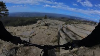
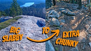
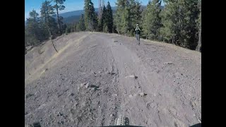
Photos of Pinecrest Mountain Bike
Videos of Pinecrest Mountain Bike

12:41 |
272 |
Dec 2, 2023 , Pinecrest

12:41 |
200 |
Dec 2, 2023 , Pinecrest
12:41 |
171 |
Dec 2, 2023 , Pinecrest
20:25 |
545 |
Feb 6, 2023 , Pinecrest
23:25 |
499 |
Nov 6, 2018 , Pinecrest
15:35 |
157 |
Nov 7, 2024 , Pinecrest
Current Trail Warnings
| status | trail | date | condition | user | info |
|---|---|---|---|---|---|
| Around the Horn | Jun 4, 2026 @ 4:58pm (America/Los_Angeles) Jun 4, 2026 | Ideal | joedirt209 | 1 Very large tree down below the... |
Recent Trail Reports
| status | trail | date | condition | info | user |
|---|---|---|---|---|---|
| Pinecrest Lower Road | Jun 22, 2026 @ 10:35am (America/Los_Angeles) 17 hours | Dry | joedirt209 | ||
| Herring Creek Road (Back Loop) | Jun 22, 2026 @ 10:34am (America/Los_Angeles) 17 hours | Dry | joedirt209 | ||
| Herring Creek Trail | Jun 22, 2026 @ 10:30am (America/Los_Angeles) 17 hours | Ideal | joedirt209 | ||
| Lupine Dirt Rd | Jun 22, 2026 @ 10:19am (America/Los_Angeles) 17 hours | Ideal | joedirt209 | ||
| Eagle Peak Trail | Jun 17, 2026 @ 7:41pm (America/Los_Angeles) Jun 17, 2026 | Ideal | thomasjkenney1024 | ||
| Rippy Bobby | Jun 11, 2026 @ 4:36pm (America/Los_Angeles) Jun 11, 2026 | Dry | joedirt209 | ||
| Tabula Rasa | Jun 11, 2026 @ 3:32pm (America/Los_Angeles) Jun 11, 2026 | Dry | joedirt209 | ||
| South Fork Stanislaus River Trail (North East) | Jun 8, 2026 @ 3:38pm (America/Los_Angeles) Jun 8, 2026 | Dry | joedirt209 | ||
| Rat Salad | Jun 4, 2026 @ 4:57pm (America/Los_Angeles) Jun 4, 2026 | Dry | joedirt209 | ||
| Eagle descent | Jun 3, 2026 @ 8:30pm (America/Los_Angeles) Jun 3, 2026 | Snow Packed | thomasjkenney1024 |
Activity Feed
| username | action | type | title | date |
|---|---|---|---|---|
| joedirt209 | add | report | activity #97570402 and 3 more | Jun 22, 2026 @ 10:20am 17 hours |
| thomasjkenney1024 | add | photo | activity #97537943 and 5 more | Jun 21, 2026 @ 7:06pm 1 day |
| thomasjkenney1024 | vote | trail | activity #97227461 | Jun 17, 2026 @ 7:43pm Jun 17, 2026 |
| thomasjkenney1024 | add | report | activity #97227446 | Jun 17, 2026 @ 7:43pm Jun 17, 2026 |
| thomasjkenney1024 | add | photo | activity #97227154 and 9 more | Jun 17, 2026 @ 7:37pm Jun 17, 2026 |
Recent Comments
| username | type | title | comment | date |
|---|---|---|---|---|
| trail | This is a great climb, lots of variety and... | Jun 3, 2026 @ 8:46pm Jun 3, 2026 | ||
| trail | I really dig this one! Very wild, lots of... | Jun 3, 2026 @ 8:44pm Jun 3, 2026 | ||
| trail | Mostly a fire road but narrows to single track... | Aug 10, 2025 @ 2:17pm Aug 10, 2025 | ||
| trail | This is a horse trail. Covered in deep silt... | Jul 10, 2025 @ 6:41pm Jul 10, 2025 | ||
| trail | If you haven't done this consider yourself... | Jul 10, 2025 @ 6:38pm Jul 10, 2025 |
Local Badges
-

Epic Ride Climb 2k66 awarded -

Climbing 10k Badge19 awarded -

Climbing 100k Badge2 awarded -

Epic Ride Descent 2k122 awarded -

Descent 10k Badge25 awarded -

Descent 100k Badge2 awarded
Bike & Skill Parks
| name | type | city | rating |
|---|---|---|---|
| Dodge Ridge Mountain Resort | bike park | Pinecrest |
Activity Type Stats
| activitytype | trails | distance | descent | descent distance | total vertical | rating | global rank | state rank | photos | reports | routes | ridelogs |
|---|---|---|---|---|---|---|---|---|---|---|---|---|
| Mountain Bike | 60 | 110 miles | 19,738 ft | 56 miles | 4,455 ft | #1,821 | #668 | 67 | 127 | 4 | 3,740 | |
| E-Bike | 28 | 65 miles | 11,962 ft | 35 miles | 3,438 ft | #2,356 | #981 | 96 | 1 | 756 | ||
| Gravel Bike | 1 | #6,501 | #2,055 | 3 | 92 | |||||||
| Horse | 48 | 128 miles | 18,406 ft | 58 miles | 5,157 ft | #259 | #440 | 35 | 1 | |||
| Hike | 65 | 154 miles | 21,624 ft | 67 miles | 5,194 ft | #436 | #200 | 18 | 119 | 10 | 985 | |
| Trail Running | 65 | 154 miles | 21,624 ft | 67 miles | 5,194 ft | #1,122 | #409 | 119 | 8 | 90 | ||
| Dirtbike/Moto | 18 | 54 miles | 6,870 ft | 24 miles | 3,399 ft | #589 | #196 | 18 | 5 | |||
| ATV/ORV/OHV | 18 | 54 miles | 6,870 ft | 24 miles | 3,399 ft | #415 | #130 | 18 | 2 | |||
| Downhill Ski | 52 | 17 miles | 9,993 ft | 14 miles | 1,421 ft | #328 | #129 | 313 |
Frequently Asked Questions About Pinecrest
▼
What are the best places to ride in Pinecrest?
Pinecrest has 2 areas to explore for mountain biking. The top rated areas are:
▼
What are the highest rated mountain biking trails in Pinecrest?
The highest rated mountain biking trails in Pinecrest are:
- Pinecrest Peak (Upper Section) (4.4/5)
- Sugar Pine Railway (4.3/5)
- Herring Creek Trail (4.2/5)
- Crabtree Lower (4.2/5)
- Olympia (4.1/5)
▼
What is the best time of the year to ride in Pinecrest?
Based on ride log data, the most popular months to ride in Pinecrest are:
- July (95 activities)
- August (90 activities)
- June (56 activities)
▼
Where can I park to ride in Pinecrest?
There are 4 parking locations listed in Pinecrest. The most popular parking spots are: View all parking and trailhead locations on the map to plan your visit.
Activities
Trails
- By brenthillier
 NSMBA TRAILFORKS & contributors
 - Admins: TheAngryTomato, PMBA
- #21267 - 16,415 views
- pinecrest activity log | embed map of Pinecrest mountain bike trails | pinecrest mountain biking points of interest
Downloading of trail gps tracks in kml & gpx formats is enabled for Pinecrest.
You must login to download files.