close
-
Layers w
- Weather Layers
- Pro
- Pro
- Pro
- Pro
- Pro
- Pro
- More Layers
- Pro
- Pro
- Pro
- Pro
-
Upgrade to

3D
Trail Conditions
- Unknown
- Snow Groomed
- Snow Packed
- Snow Covered
- Snow Cover Partial
- Freeze/thaw Cycle
- Icy
- Prevalent Mud
- Wet
- Variable
- Ideal
- Dry
- Very Dry
Trail Flow (Ridden Direction)
Trailforks scans users ridelogs to determine the most popular direction each trail is ridden. A good flowing trail network will have most trails flowing in a single direction according to their intension.
The colour categories are based on what percentage of riders are riding a trail in its intended direction.
The colour categories are based on what percentage of riders are riding a trail in its intended direction.
- > 96%
- > 90%
- > 80%
- > 70%
- > 50%
- < 50%
- bi-directional trail
- no data
Trail Last Ridden
Trailforks scans ridelogs to determine the last time a trail was ridden.
- < 2 days
- < 1 week
- < 2 weeks
- < 1 month
- < 6 months
- > 6 months
Trail Ridden Direction
The intended direction a trail should be ridden.
- Downhill Only
- Downhill Primary
- Both Directions
- Uphill Primary
- Uphill Only
- One Direction
Contribute Details
Colors indicate trail is missing specified detail.
- Description
- Photos
- Description & Photos
- Videos
Trail Popularity ?
Trailforks scans ridelogs to determine which trails are ridden the most in the last 9 months.
Trails are compared with nearby trails in the same city region with a possible 25 colour shades.
Think of this as a heatmap, more rides = more kinetic energy = warmer colors.
- most popular
- popular
- less popular
- not popular
ATV/ORV/OHV Filter
Max Vehicle Width
inches
US Cell Coverage
Legend

Radar Time
Activity Recordings
Trailforks uses anonymized public activity data.
?
Activity Recordings
Trailforks uses anonymized public activity data.
?
Personal Heatmap
▶
Activity Types
all
/
none
▶
Options
2
Date range
month
–
Winter Trails
Warning
A routing network for winter maps does not exist. Selecting trails using the winter trails layer has been disabled.
Missing Trails
Most Popular
Least Popular
Trails are colored based on popularity. The more popular a trail is, the more red. Less popular trails trend towards green.
Jump Magnitude Heatmap
Heatmap of where riders jump on trails. Zoom in to see individual jumps, click circles to view jump details.
BC Backroad Status
![map legend]()
Service Road Atlas is a free to use, community-driven service for viewing and creating reports on the numerous back-country service roads around B.C. and Alberta.

Slope Aspect
Direction the slope faces
Trails Deemphasized
Trails are shown in grey.
Only show trails with no bike usage.
Suggested Layers
Based on selected activity type
Save the current map location and zoom level as your default home location whenever this page is loaded.
Save
No description for Pleinfeld has been added yet!
Login or register to submit one.
This region uses the Uk/Euro style trail grading system.
Activities Click to view
- Mountain Bike
5 trails
- E-Bike
4 trails
- Hike
5 trails
- Trail Running
5 trails
Region Details
- 2
- 2
Region Status
Open as of Jul 28, 2025Stats
- Avg Trail Rating
- Trails (view details)
- 4
- Trails Mountain Bike
- 5
- Trails E-Bike
- 4
- Trails Hike
- 5
- Trails Trail Running
- 5
- Total Distance
- 2,208 ft
- Total Descent Distance
- 2,162 ft
- Total Descent
- 305 ft
- Total Vertical
- 305 ft
- Highest Trailhead
- 1,568 ft
- Reports
- 16
- Photos
- 8
- Ridden Counter
- 70
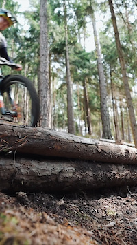
Popular Pleinfeld Mountain Biking Trails
• 50 ★ 5.0 • 2,333 ft • 0 ft • 11 •
Verspielt und abwechslungsreich. Schwirigkeit S1 mit ein Paar S2 Abschnitten. Obere Sektion wurzelig mit kleinen Drops. In der Mitte befindet sich ein ca. 1,5 m Drop der umfahrbar ist. Ab dem Drop wird die Strecke zu einer schnellen...
Videos of Pleinfeld Mountain Bike
trail: Walzer Cup neu
2:18 |
83 |
Aug 18, 2025
Recent Trail Reports
| status | trail | date | condition | info | user |
|---|---|---|---|---|---|
| Römerpfad | Jul 28, 2025 @ 6:13pm Jul 28, 2025 | Wet | HHKK | ||
| Walzer Cup alt | Jun 25, 2025 @ 6:38pm Jun 25, 2025 | Very Dry | HHKK |
Activity Feed
| username | action | type | title | date |
|---|---|---|---|---|
| HHKK | vote | trail | activity #89840257 | Mar 2, 2026 @ 7:58am Mar 2, 2026 |
| HHKK | vote | trail | activity #81941040 | Oct 8, 2025 @ 7:10am Oct 8, 2025 |
| HHKK | add | report | activity #76907126 | Jul 28, 2025 @ 12:41pm Jul 28, 2025 |
| Sasse82 | update | trail | activity #74886530 | Jun 30, 2025 @ 7:08am Jun 30, 2025 |
| HHKK | add | trail | activity #74886490 | Jun 30, 2025 @ 7:08am Jun 30, 2025 |
Bike & Skill Parks
| name | type | city | rating |
|---|---|---|---|
| Eichenberg motocross | skill park | Pleinfeld |
Activity Type Stats
| activitytype | trails | distance | descent | descent distance | total vertical | rating | global rank | state rank | photos | reports | routes | ridelogs |
|---|---|---|---|---|---|---|---|---|---|---|---|---|
| Mountain Bike | 5 | 2,208 ft | 305 ft | 2,162 ft | 305 ft | #6,988 | #243 | 8 | 16 | 1,007 | ||
| E-Bike | 4 | 2,208 ft | 305 ft | 2,162 ft | 305 ft | #7,100 | #319 | 16 | 43 | |||
| Hike | 5 | 2,208 ft | 305 ft | 2,162 ft | 305 ft | #10,814 | #288 | 16 | 119 | |||
| Trail Running | 5 | 2,208 ft | 305 ft | 2,162 ft | 305 ft | #10,304 | #286 | 15 |
- By drgrinspoon
 & contributors
 - Admins: larry81541
- #20818 - 2,305 views
- pleinfeld activity log | embed map of Pleinfeld mountain bike trails |
Downloading of trail gps tracks in kml & gpx formats is enabled for Pleinfeld.
You must login to download files.