close
-
Layers w
- Weather Layers
- Pro
- Pro
- Pro
- Pro
- Pro
- Pro
- More Layers
- Pro
- Pro
- Pro
- Pro
-
Upgrade to

3D
Trail Conditions
- Unknown
- Snow Groomed
- Snow Packed
- Snow Covered
- Snow Cover Partial
- Freeze/thaw Cycle
- Icy
- Prevalent Mud
- Wet
- Variable
- Ideal
- Dry
- Very Dry
Trail Flow (Ridden Direction)
Trailforks scans users ridelogs to determine the most popular direction each trail is ridden. A good flowing trail network will have most trails flowing in a single direction according to their intension.
The colour categories are based on what percentage of riders are riding a trail in its intended direction.
The colour categories are based on what percentage of riders are riding a trail in its intended direction.
- > 96%
- > 90%
- > 80%
- > 70%
- > 50%
- < 50%
- bi-directional trail
- no data
Trail Last Ridden
Trailforks scans ridelogs to determine the last time a trail was ridden.
- < 2 days
- < 1 week
- < 2 weeks
- < 1 month
- < 6 months
- > 6 months
Trail Ridden Direction
The intended direction a trail should be ridden.
- Downhill Only
- Downhill Primary
- Both Directions
- Uphill Primary
- Uphill Only
- One Direction
Contribute Details
Colors indicate trail is missing specified detail.
- Description
- Photos
- Description & Photos
- Videos
Trail Popularity ?
Trailforks scans ridelogs to determine which trails are ridden the most in the last 9 months.
Trails are compared with nearby trails in the same city region with a possible 25 colour shades.
Think of this as a heatmap, more rides = more kinetic energy = warmer colors.
- most popular
- popular
- less popular
- not popular
ATV/ORV/OHV Filter
Max Vehicle Width
inches
US Cell Coverage
Legend

Radar Time
Activity Recordings
Trailforks uses anonymized public activity data.
?
Activity Recordings
Trailforks uses anonymized public activity data.
?
Personal Heatmap
▶
Activity Types
all
/
none
▶
Options
2
Date range
month
–
Winter Trails
Warning
A routing network for winter maps does not exist. Selecting trails using the winter trails layer has been disabled.
Missing Trails
Most Popular
Least Popular
Trails are colored based on popularity. The more popular a trail is, the more red. Less popular trails trend towards green.
Jump Magnitude Heatmap
Heatmap of where riders jump on trails. Zoom in to see individual jumps, click circles to view jump details.
BC Backroad Status
![map legend]()
Service Road Atlas is a free to use, community-driven service for viewing and creating reports on the numerous back-country service roads around B.C. and Alberta.

Slope Aspect
Direction the slope faces
Trails Deemphasized
Trails are shown in grey.
Only show trails with no bike usage.
Suggested Layers
Based on selected activity type
Save the current map location and zoom level as your default home location whenever this page is loaded.
Save
No description for Ranzi has been added yet!
Login or register to submit one.
This region uses the Uk/Euro style trail grading system.
Activities Click to view
- Mountain Bike
11 trails
- E-Bike
6 trails
- Adaptive Bike
0 trails
- Winter Fat Bike
0 trails
- Hike
7 trails
- Trail Running
7 trails
Region Details
- 1
- 2
- 6
Region Status
Open as of Jun 2, 2026Stats
- Avg Trail Rating
- Trails (view details)
- 11
- Trails Mountain Bike
- 11
- Trails E-Bike
- 6
- Trails Hike
- 7
- Trails Trail Running
- 7
- Total Distance
- 5 miles
- Total Descent
- 3,694 ft
- Total Vertical
- 1,033 ft
- Highest Trailhead
- 1,386 ft
- Reports
- 335
- Photos
- 47
- Ridden Counter
- 3,932
Popular Ranzi Mountain Biking Trails
• 95 ★ 4.6 • 3,291 ft • 0 ft • 503 •
Highly rated popular red difficulty singletrack. This mountain bike primary trail can be used downhill only with a 0 ft blue climb. Trail visibility is always easy to follow. On average it takes 4 minutes to complete this trail.
• 65 ★ 4.7 • 2,989 ft • 0 ft • 397 •
This Trail came from Ranzi Region down to the little Village of Verzi. Nice Berms section in he middle, last part is a rock sections but fun to ride.
• 85 ★ 4.3 • 1,289 ft • 44 ft • 311 •
Highly rated popular blue difficulty singletrack. This mountain bike primary trail can be used downhill primary and has a moderate overall physical rating. On average it takes 2 minutes to complete this trail.
• 100 ★ 4.7 • 630 ft • 0 ft • 299 •
nuova traccia della seconda parte del trail armuin...ti porta sempre nei prati come l altro...la vecchia traccia se ne sconsiglia l uso perche molto sporca e si rischia di far dei danni
• 55 ★ 4.3 • 528 ft • 35 ft • 250 •
Moderately popular blue difficulty singletrack. This mountain bike primary trail can be used downhill primary and has a easy overall physical rating with a 35 ft blue climb. On average it takes minutes to complete this trail.
• 30 ★ 3.7 • 4,912 ft • 152 ft • 242 •
In fondo troverete 2 cancelli. L'accesso è consentito, ricordatevi di chiuderli At the bottom of the trail you'll find 2 gates. The access is granted but remember to close them
• 75 ★ 5.0 • 1,414 ft • 0 ft • 158 •
semplice discesa...breve ma intensa....si alterna un primo tratto veloce con alcuni salti naturali.mentre la seconda parte son stati creati dei bei tornanti
• 40 ★ 4.5 • 1,217 ft • 0 ft • 152 •
Moderately popular blue difficulty singletrack. This mountain bike primary trail can be used downhill only and has a easy overall physical rating. On average it takes 1 minutes to complete this trail.
Photos of Ranzi Mountain Bike
Videos of Ranzi Mountain Bike
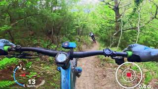
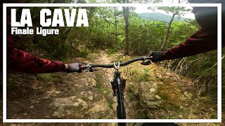
trail: La Cava
23 |
Apr 29, 2026 , Ranzi
trail: La Cava
3:15 |
47 |
Nov 19, 2025 , Ranzi
trail: Scala Santa
10:56 |
119 |
Oct 2, 2025 , Ranzi
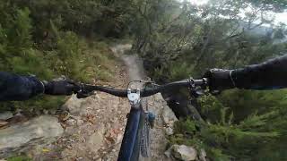
trail: La Cava
2:57 |
161 |
Jul 14, 2024 , Ranzi
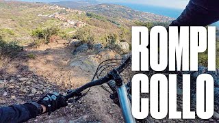
![Dolcenera aka Rompicollo [Full run] - Finale...](https://ev1.pinkbike.org/tf/vt/1/yvt-201887-4.jpg)
trail: Dolcenera
3:51 |
488 |
May 15, 2024 , Ranzi
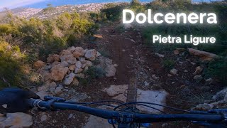
trail: Dolcenera
4:30 |
264 |
Feb 5, 2024 , Ranzi
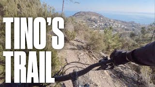
trail: Tino's Trail Easy
0:35 |
274 |
May 19, 2023 , Ranzi
trail: Dolcenera
4:17 |
766 |
Feb 17, 2023 , Ranzi
Current Trail Warnings
| status | trail | date | condition | user | info |
|---|---|---|---|---|---|
| Tino's Trail Easy | May 24, 2026 @ 1:26pm (Europe/Rome) May 24, 2026 | Very Dry | atrainofficial321 | mother Nature has reclaimed a lot of this... |
Recent Trail Reports
| status | trail | date | condition | info | user |
|---|---|---|---|---|---|
| Scoglio di Venso | Jun 2, 2026 @ 2:53pm (Europe/Monaco) Jun 2, 2026 | Ideal | pufalot TRAILFORKS | ||
| Dolcenera | May 21, 2026 @ 2:46pm (Europe/Monaco) May 21, 2026 | Dry | arthurit | ||
| Back to Ranzi | May 21, 2026 @ 2:46pm (Europe/Monaco) May 21, 2026 | Dry | arthurit | ||
| Armuin 2 parte new line | May 21, 2026 @ 2:46pm (Europe/Monaco) May 21, 2026 | Ideal | arthurit | ||
| La Cava | May 19, 2026 @ 12:39pm (Europe/Monaco) May 19, 2026 | Ideal | arthurit | ||
| Scala Santa | Apr 25, 2026 @ 8:58am (Europe/Monaco) Apr 24, 2026 | Ideal | glauconicola | ||
| 5 alberi | Apr 4, 2026 @ 3:16pm (Europe/Monaco) Apr 4, 2026 | Ideal | Mattebolla91 | ||
| Trincea | Jan 24, 2026 @ 9:38am (Europe/Rome) Jan 24, 2026 | Ideal | Benni23186 | ||
| Cian de Belle Climb | Jan 3, 2026 @ 6:49pm (Europe/Rome) Jan 3, 2026 | Ideal | ktm-boy-69 TRAILFORKS | ||
| Nostralino | Sep 5, 2025 @ 8:40am Sep 5, 2025 | Ideal | korius |
Activity Feed
| username | action | type | title | date |
|---|---|---|---|---|
| spezies8472 | wishlist | trail | activity #96983258 | Jun 14, 2026 @ 10:20am 1 day |
| RunarH | ridden | trail | activity #96533866 | Jun 8, 2026 @ 5:57am Jun 8, 2026 |
| pufalot | add | report | activity #96086566 | Jun 2, 2026 @ 8:35am Jun 2, 2026 |
| Chrischel | wishlist | trail | activity #96063746 | Jun 1, 2026 @ 10:55pm Jun 1, 2026 |
| michaeljebb | ridden | trail | activity #95755098 and 2 more | May 28, 2026 @ 8:54pm May 28, 2026 |
Recent Comments
| username | type | title | comment | date |
|---|---|---|---|---|
| trail | Great, underrated trail. Definitely a black.... | Jan 22, 2026 @ 12:31am Jan 22, 2026 | ||
| trail | nice flowy and easy trail. good one at the end... | Jan 3, 2026 @ 11:58am Jan 3, 2026 | ||
| trail | nice enduro-trail with some quite fast parts... | Jan 3, 2026 @ 11:57am Jan 3, 2026 | ||
| trail | flowy and nice to ride single-trail. be... | Jan 3, 2026 @ 11:51am Jan 3, 2026 | ||
| trail | nice flowy section. | Jan 3, 2026 @ 11:42am Jan 3, 2026 |
Local Badges
-

Epic Ride Climb 2k17 awarded -

Climbing 10k Badge3 awarded -

Climbing 100k Badge0 awarded -

Epic Ride Descent 2k51 awarded -

Descent 10k Badge5 awarded -

Descent 100k Badge0 awarded
Activity Type Stats
| activitytype | trails | distance | descent | descent distance | total vertical | rating | global rank | state rank | photos | reports | routes | ridelogs |
|---|---|---|---|---|---|---|---|---|---|---|---|---|
| Mountain Bike | 11 | 5 miles | 3,694 ft | 4 miles | 1,033 ft | #4,540 | #308 | 39 | 335 | 764 | ||
| E-Bike | 6 | 3 miles | 2,211 ft | 2 miles | 958 ft | #6,606 | #691 | 8 | 292 | 291 | ||
| Hike | 7 | 3 miles | 1,962 ft | 2 miles | 1,033 ft | #10,907 | #792 | 297 | 28 | |||
| Trail Running | 7 | 3 miles | 1,962 ft | 2 miles | 1,033 ft | #10,330 | #781 | 297 | 46 |
Frequently Asked Questions About Ranzi
▼
What are the highest rated mountain biking trails in Ranzi?
The highest rated mountain biking trails in Ranzi are:
- Dolcenera (4.4/5)
- La Cava (4.3/5)
- Trincea (4.2/5)
- Armuin 2 parte new line (4.2/5)
- Scoglio di Venso (4.1/5)
▼
What is the best time of the year to ride in Ranzi?
Based on ride log data, the most popular months to ride in Ranzi are:
- June (7 activities)
- September (7 activities)
- July (6 activities)
▼
Where can I park to ride in Ranzi?
There are 1 parking locations listed in Ranzi. The most popular parking spots are:
▼
What is the longest trail in Ranzi?
The longest trail in Ranzi is 5 alberi at 4,912 ft. View all trails sorted by distance.
- By denitopia
 TRAILFORKS VTA & contributors
 - Admins: denitopia
- #14969 - 4,424 views
- ranzi activity log | embed map of Ranzi mountain bike trails | ranzi mountain biking points of interest
Downloading of trail gps tracks in kml & gpx formats is enabled for Ranzi.
You must login to download files.