close
-
Layers w
- Weather Layers
- Pro
- Pro
- Pro
- Pro
- Pro
- Pro
- More Layers
- Pro
- Pro
- Pro
- Pro
-
Upgrade to

3D
Trail Conditions
- Unknown
- Snow Groomed
- Snow Packed
- Snow Covered
- Snow Cover Partial
- Freeze/thaw Cycle
- Icy
- Prevalent Mud
- Wet
- Variable
- Ideal
- Dry
- Very Dry
Trail Flow (Ridden Direction)
Trailforks scans users ridelogs to determine the most popular direction each trail is ridden. A good flowing trail network will have most trails flowing in a single direction according to their intension.
The colour categories are based on what percentage of riders are riding a trail in its intended direction.
The colour categories are based on what percentage of riders are riding a trail in its intended direction.
- > 96%
- > 90%
- > 80%
- > 70%
- > 50%
- < 50%
- bi-directional trail
- no data
Trail Last Ridden
Trailforks scans ridelogs to determine the last time a trail was ridden.
- < 2 days
- < 1 week
- < 2 weeks
- < 1 month
- < 6 months
- > 6 months
Trail Ridden Direction
The intended direction a trail should be ridden.
- Downhill Only
- Downhill Primary
- Both Directions
- Uphill Primary
- Uphill Only
- One Direction
Contribute Details
Colors indicate trail is missing specified detail.
- Description
- Photos
- Description & Photos
- Videos
Trail Popularity ?
Trailforks scans ridelogs to determine which trails are ridden the most in the last 9 months.
Trails are compared with nearby trails in the same city region with a possible 25 colour shades.
Think of this as a heatmap, more rides = more kinetic energy = warmer colors.
- most popular
- popular
- less popular
- not popular
ATV/ORV/OHV Filter
Max Vehicle Width
inches
US Cell Coverage
Legend

Radar Time
Activity Recordings
Trailforks uses anonymized public activity data.
?
Activity Recordings
Trailforks uses anonymized public activity data.
?
Personal Heatmap
▶
Activity Types
all
/
none
▶
Options
2
Date range
month
–
Winter Trails
Warning
A routing network for winter maps does not exist. Selecting trails using the winter trails layer has been disabled.
Missing Trails
Most Popular
Least Popular
Trails are colored based on popularity. The more popular a trail is, the more red. Less popular trails trend towards green.
Jump Magnitude Heatmap
Heatmap of where riders jump on trails. Zoom in to see individual jumps, click circles to view jump details.
BC Backroad Status
![map legend]()
Service Road Atlas is a free to use, community-driven service for viewing and creating reports on the numerous back-country service roads around B.C. and Alberta.

Slope Aspect
Direction the slope faces
Trails Deemphasized
Trails are shown in grey.
Only show trails with no bike usage.
Suggested Layers
Based on selected activity type
Save the current map location and zoom level as your default home location whenever this page is loaded.
Save
No description for Rendsburg has been added yet!
Login or register to submit one.
This region uses the Uk/Euro style trail grading system.
Activities Click to view
- Mountain Bike
34 trails
- E-Bike
34 trails
- Adaptive Bike
0 trails
- Hike
22 trails
- Trail Running
22 trails
Region Details
- 13
- 10
- 11
Region Status
Open as of May 23, 2023Stats
- Avg Trail Rating
- Trails (view details)
- 34
- Trails Mountain Bike
- 34
- Trails E-Bike
- 34
- Trails Hike
- 22
- Trails Trail Running
- 22
- Total Distance
- 9 miles
- Total Descent
- 1,946 ft
- Total Vertical
- 281 ft
- Highest Trailhead
- 379 ft
- Reports
- 161
- Photos
- 2
- Ridden Counter
- 1,323
Popular Rendsburg Mountain Biking Trails
• 35 ★ 0.0 • 952 ft • 16 ft • 44 •
Fast and easy trail with a few jumps and berms in the lower sectrion. Part of the Hüttener Berge (Hütti) round trip.
• 100 ★ 5.0 • 848 ft • 11 ft • 41 •
Fun trail with a jump in the upper section and twisty turns at the bottom. Part of the Hüttener Berge (Hütti) round trip.
• 90 ★ 0.0 • 1,982 ft • 73 ft • 41 •
Trail on the north side of Hüttener Berge with an optional jump. Part of the Hüttener Berge (Hütti) round trip
• 50 ★ 0.0 • 788 ft • 40 ft • 39 •
Fast and flowy trail. Part of the Hüttener Berge (Hütti) round course.
Rendsburg Mountain Bike Routes
★ 5.0 • 8 miles • 1,087 ft • 0 •
Round course with blue arrow signs (normal round trip), yellow arrow (short cuts) and red arrows...
Videos of Rendsburg Mountain Bike
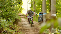
trail: Short cut
2:43 |
929 |
Mar 6, 2012
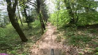
trail: Heidberg DH
0:53 |
159 |
May 23, 2023 , Rendsburg
Recent Trail Reports
| status | trail | date | condition | info | user |
|---|---|---|---|---|---|
| Heidberg DH | May 23, 2023 @ 2:50am May 23, 2023 | Dry | Weirdcan | ||
| Hütti Connection | Sep 28, 2021 @ 1:57am Sep 28, 2021 | Ideal | BalticMoe | ||
| Short cut | Sep 28, 2021 @ 1:57am Sep 28, 2021 | Ideal | BalticMoe | ||
| Sandbox | Sep 28, 2021 @ 1:57am Sep 28, 2021 | Ideal | BalticMoe | ||
| Verbindungsstück | Sep 28, 2021 @ 1:57am Sep 28, 2021 | Ideal | BalticMoe | ||
| Forsthaus Flow Trail | Sep 28, 2021 @ 1:57am Sep 28, 2021 | Ideal | BalticMoe | ||
| Immenberg | Sep 28, 2021 @ 1:57am Sep 28, 2021 | Ideal | BalticMoe | ||
| Gisbert-Rampe | Sep 28, 2021 @ 1:57am Sep 28, 2021 | Variable | BalticMoe | ||
| Armin-Schleife | Sep 28, 2021 @ 1:57am Sep 28, 2021 | Variable | BalticMoe | ||
| Abkürzung bei Ralph-Hang | Sep 28, 2021 @ 1:57am Sep 28, 2021 | Variable | BalticMoe |
Activity Feed
| username | action | type | title | date |
|---|---|---|---|---|
| ch4rl3x | wishlist | region | activity #92644124 | Apr 14, 2026 @ 11:53pm Apr 14, 2026 |
| MrJeffHunteroJwDJS | wishlist | route | activity #90083350 | Mar 6, 2026 @ 2:19pm Mar 6, 2026 |
| BjrnZXVd2H | wishlist | route | activity #90027959 | Mar 5, 2026 @ 1:36pm Mar 5, 2026 |
| Bbkdk | ridden | route | activity #86999876 | Jan 11, 2026 @ 1:40am Jan 11, 2026 |
| Igor_der_Metzger | wishlist | region | activity #76046826 | Jul 16, 2025 @ 1:47pm Jul 16, 2025 |
Local Badges
-

10 Blue Trails10 awarded -

Epic Ride Climb 2k0 awarded -

Climbing 10k Badge1 awarded -

Climbing 100k Badge0 awarded -

Completionist1 awarded -

Epic Ride Descent 2k0 awarded
Bike & Skill Parks
| name | type | city | rating |
|---|---|---|---|
| BMX Bahn Rendsburg | skill park | Rendsburg |
Activity Type Stats
| activitytype | trails | distance | descent | descent distance | total vertical | rating | global rank | state rank | photos | reports | routes | ridelogs |
|---|---|---|---|---|---|---|---|---|---|---|---|---|
| Mountain Bike | 34 | 9 miles | 1,946 ft | 5 miles | 282 ft | #6,031 | #169 | 2 | 161 | 1 | 551 | |
| E-Bike | 34 | 9 miles | 1,946 ft | 5 miles | 282 ft | #4,931 | #158 | 161 | 147 | |||
| Hike | 22 | 6 miles | 1,201 ft | 3 miles | 279 ft | #9,087 | #193 | 161 | 60 | |||
| Trail Running | 22 | 6 miles | 1,201 ft | 3 miles | 279 ft | #8,624 | #185 | 161 |
Frequently Asked Questions About Rendsburg
▼
What are the highest rated mountain biking trails in Rendsburg?
The highest rated mountain biking trails in Rendsburg are:
- Heidberg DH (4.1/5)
- Wiesen Trail (0/5)
- Hütti Connection (0/5)
- Amtsdirektor-Betz-Schleife (0/5)
- Ralph-Hang (0/5)
▼
What is the best time of the year to ride in Rendsburg?
Based on ride log data, the most popular months to ride in Rendsburg are:
- July (36 activities)
- August (31 activities)
- June (27 activities)
▼
Where can I park to ride in Rendsburg?
Check the Rendsburg trail map for trailhead and parking information. Community members regularly update access and parking details for trails in the area.
▼
What is the longest trail in Rendsburg?
The longest trail in Rendsburg is Schwarzwald-Schleife at 3,029 ft. View all trails sorted by distance.
- By Windfinder
 & contributors
 - Admins: Windfinder
- #27023 - 1,416 views
- rendsburg activity log | embed map of Rendsburg mountain bike trails |
Downloading of trail gps tracks in kml & gpx formats is enabled for Rendsburg.
You must login to download files.