close
-
Layers w
- Weather Layers
- Pro
- Pro
- Pro
- Pro
- Pro
- Pro
- More Layers
- Pro
- Pro
- Pro
- Pro
-
Upgrade to

3D
Trail Conditions
- Unknown
- Snow Groomed
- Snow Packed
- Snow Covered
- Snow Cover Partial
- Freeze/thaw Cycle
- Icy
- Prevalent Mud
- Wet
- Variable
- Ideal
- Dry
- Very Dry
Trail Flow (Ridden Direction)
Trailforks scans users ridelogs to determine the most popular direction each trail is ridden. A good flowing trail network will have most trails flowing in a single direction according to their intension.
The colour categories are based on what percentage of riders are riding a trail in its intended direction.
The colour categories are based on what percentage of riders are riding a trail in its intended direction.
- > 96%
- > 90%
- > 80%
- > 70%
- > 50%
- < 50%
- bi-directional trail
- no data
Trail Last Ridden
Trailforks scans ridelogs to determine the last time a trail was ridden.
- < 2 days
- < 1 week
- < 2 weeks
- < 1 month
- < 6 months
- > 6 months
Trail Ridden Direction
The intended direction a trail should be ridden.
- Downhill Only
- Downhill Primary
- Both Directions
- Uphill Primary
- Uphill Only
- One Direction
Contribute Details
Colors indicate trail is missing specified detail.
- Description
- Photos
- Description & Photos
- Videos
Trail Popularity ?
Trailforks scans ridelogs to determine which trails are ridden the most in the last 9 months.
Trails are compared with nearby trails in the same city region with a possible 25 colour shades.
Think of this as a heatmap, more rides = more kinetic energy = warmer colors.
- most popular
- popular
- less popular
- not popular
ATV/ORV/OHV Filter
Max Vehicle Width
inches
US Cell Coverage
Legend

Radar Time
Activity Recordings
Trailforks uses anonymized public activity data.
?
Activity Recordings
Trailforks uses anonymized public activity data.
?
Personal Heatmap
▶
Activity Types
all
/
none
▶
Options
2
Date range
month
–
Winter Trails
Warning
A routing network for winter maps does not exist. Selecting trails using the winter trails layer has been disabled.
Missing Trails
Most Popular
Least Popular
Trails are colored based on popularity. The more popular a trail is, the more red. Less popular trails trend towards green.
Jump Magnitude Heatmap
Heatmap of where riders jump on trails. Zoom in to see individual jumps, click circles to view jump details.
BC Backroad Status
![map legend]()
Service Road Atlas is a free to use, community-driven service for viewing and creating reports on the numerous back-country service roads around B.C. and Alberta.

Slope Aspect
Direction the slope faces
Trails Deemphasized
Trails are shown in grey.
Only show trails with no bike usage.
Suggested Layers
Based on selected activity type
Save the current map location and zoom level as your default home location whenever this page is loaded.
Save
No description for Rhône has been added yet!
Login or register to submit one.
This region uses the Uk/Euro style trail grading system.
Activities Click to view
- Mountain Bike
261 trails
- E-Bike
226 trails
- Horse
30 trails
- Hike
142 trails
- Trail Running
143 trails
Region Details
- 49
- 55
- 77
- 55
- 20
Stats
- Avg Trail Rating
- Trails (view details)
- 256
- Trails Mountain Bike
- 261
- Trails E-Bike
- 226
- Trails Horse
- 30
- Trails Hike
- 142
- Trails Trail Running
- 143
- Trails Dirtbike/Moto
- 3
- Trails Observed Trials
- 1
- Trails ATV/ORV/OHV
- 1
- Total Distance
- 140 miles
- Total Descent
- 52,566 ft
- Total Vertical
- 2,437 ft
- Highest Trailhead
- 2,917 ft
- Reports
- 1,978
- Photos
- 239
- Ridden Counter
- 14,248
Articles
Video: Long Jumps and Big Tricks at the Rock Metal Jam
Jul 30, 2019 from pinkbike.com
Pierre-Edouard Ferry's Jam makes a comeback after nearly a decade.
Sub Regions
- Brindas (0)
- Chasselay (4)
- Cogny (16)
- Feyzin (3)
- Irigny (1)
- L'Arbresle (1)
- Loire-sur-Rhône (11)
- Longes (6)
- Lyon (113)
- Bike Park Courzieu (5)
- Les Monts d'Or (63)
- Montagny (1)
- Montmelas-Saint-Sorlin (8)
- Mornant (3)
- Pollionnay (3)
- Régnié-Durette (16)
- Septème (1)
- Vaugneray (1)
- Vienne (4)
- Vourles (2)
- Monts du Lyonnais (90)
Popular Rhône Mountain Biking Trails
• 95 ★ 3.5 • 1,227 ft • 0 ft • 142 •
Popular blue difficulty singletrack. This mountain bike primary trail can be used downhill only. Trail visibility is always easy to follow. On average it takes minutes to complete this trail.
• 80 ★ 5.0 • 1 mile • 0 ft • 122 •
Popular red difficulty singletrack. This mountain bike primary trail can be used downhill only and has a moderate overall physical rating. It features drop, jump and gap jump. Trail visibility is always easy to follow. On average it takes 9 minutes to complete this trail.
• 95 ★ 4.0 • 1,421 ft • 0 ft • 118 •
Première piste autorisée officiellement par la mairie de Pollionnay et construite par l'association .
• 95 ★ 4.8 • 3,159 ft • 0 ft • 115 •
Joli single assez technique avec quelques champs de pierres et drops. La plupart des drops sont petits, seul le dernier juste avant la fin du sentier est plutôt conséquent, mais contournable.
• 80 ★ 4.0 • 1,860 ft • 0 ft • 114 •
Popular blue difficulty singletrack. This mountain bike primary trail can be used downhill only and has a moderate overall physical rating. It features rock garden. Trail visibility is always easy to follow. On average it takes 2 minutes to complete this trail.
• 85 ★ 4.7 • 4,738 ft • 6 ft • 111 •
Commence tranquille au début, mais ne vous y méprenez pas ! vraie DH sans construction humaine trop importante, plein de défis et d'approches différentes dans la DH. Attention, il faudra remonter ;) !
Rhône Mountain Bike Routes
2 miles • 673 ft • 9 • Loop •
Découverte des deux premières pistes officielles des Monts du Lyonnais, et , depuis le parking de la...
20 miles • 4,637 ft • 20 •
Randuro pas compliqué mais un peu physique dans les monts
12 miles • 4,201 ft • 11 •
Parcours regroupant un panelle de piste rouge avec 1220 m de dénivelé pour 19.7km.
2 miles • 38 ft • 2 • Out & Back •
Départ / Arrivée : Longes - Col de Chassenoud Depuis le parking du Col, partir à l’opposé de la...
12 miles • 2,875 ft • 7 • Loop •
Plusieurs single dans les monts du lyonnais de la DH et du single avec quelques jumps
★ 5.0 • 25 miles • 2,365 ft • 0 • Loop •
Septème : Départ-arrivée à la cabane des chasseurs de Septème, dans le bois de Chapulay. Parcours...
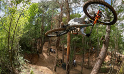
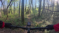
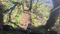
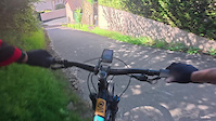
Videos of Rhône Mountain Bike
trail: La Secrète Enduro
2:50 |
8 |
Apr 6, 2026
trail: Sentier Des Alagneraies
2:15 |
8 |
Apr 6, 2026
trail: Route PifPaf
2:05 |
9 |
Apr 6, 2026
trail: Mont Py vers Moulin
2:05 |
5 |
Apr 6, 2026
trail: Enduro La Germinoise
7:27 |
8 |
Apr 6, 2026
trail: Faily
0:06 |
33 |
Aug 14, 2025
trail: Cemetery Access
0:44 |
22 |
Feb 22, 2025

trail: Chute Saint Romain
0:26 |
40 |
Feb 22, 2025
Current Trail Warnings
| status | trail | date | condition | user | info |
|---|---|---|---|---|---|
| Accès Stoem Monts du Lyonnais | Jun 18, 2026 @ 10:42am (Europe/Paris) 3 hours | Unknown | obez | La Stoem (Haute) est fermée, fermeture... | |
| Stoem Monts du Lyonnais | Jun 14, 2026 @ 4:49pm (Europe/Paris) Jun 14, 2026 | Dry | Elowan19 | ||
| Secrète Monts du Lyonnais | May 26, 2026 @ 5:38pm (Europe/Paris) May 26, 2026 | Unknown | obez | Arbres tombés au début après premier... |
Recent Trail Reports
Activity Feed
| username | action | type | title | date |
|---|---|---|---|---|
| obez | add | report | activity #97238283 | Jun 18, 2026 @ 1:42am 3 hours |
| Elowan19 | add | report | activity #96968186 | Jun 14, 2026 @ 7:49am Jun 14, 2026 |
| obez | add | report | activity #96889407 | Jun 13, 2026 @ 9:47am Jun 13, 2026 |
| VyQ8YB | wishlist | trail | activity #96852719 and 3 more | Jun 13, 2026 @ 12:50am Jun 13, 2026 |
| educhene69 | add | report | activity #96615819 | Jun 9, 2026 @ 10:36am Jun 9, 2026 |
Recent Comments
| username | type | title | comment | date |
|---|---|---|---|---|
| report | Oui, j'ai vu ça aussi... J'apporterai ma... | Apr 24, 2026 @ 8:42am Apr 24, 2026 | ||
| trail | Sentier vraiment technique de part les virages... | Apr 6, 2026 @ 11:20am Apr 6, 2026 | ||
| trail | Après la petite montée, le chemin... | Apr 6, 2026 @ 11:18am Apr 6, 2026 | ||
| report | Trail is not really rideable half way through. | Mar 17, 2026 @ 1:24pm Mar 17, 2026 | ||
| trail | Sait-on pourquoi ? la commune souhaite... | Mar 7, 2026 @ 5:30am Mar 7, 2026 |
Local Badges
-

Epic Ride Descent 2k0 awarded -

Descent 10k Badge0 awarded -
Descent 10k Badge1 awarded -
Epic Ride Descent 2k0 awarded -

Mountain Biking 100k Badge0 awarded -
Mountain Biking 100k Badge0 awarded
Bike & Skill Parks
| name | type | city | rating |
|---|---|---|---|
| Planèt'Bosses terrain dirt / BMX | skill park | Mornant | |
| pumptrack brindas | skill park | Brindas | |
| pumptrack Sourcieux-les-Mines | skill park | Sourcieux-les-Mines | |
| Bike Park de Genas | skill park | Genas | |
| WeRide | skill park | Lyon |
Activity Type Stats
| activitytype | trails | distance | descent | descent distance | total vertical | rating | global rank | state rank | photos | reports | routes | ridelogs |
|---|---|---|---|---|---|---|---|---|---|---|---|---|
| Mountain Bike | 261 | 140 miles | 52,566 ft | 84 miles | 2,438 ft | 237 | 1,978 | 38 | 27,558 | |||
| E-Bike | 226 | 121 miles | 44,590 ft | 69 miles | 2,438 ft | 2 | 1,220 | 12 | 3,190 | |||
| Horse | 30 | 20 miles | 2,966 ft | 8 miles | 2,349 ft | 110 | ||||||
| Hike | 142 | 89 miles | 16,014 ft | 41 miles | 2,438 ft | 444 | 1 | 506 | ||||
| Trail Running | 143 | 91 miles | 16,260 ft | 42 miles | 2,438 ft | 448 | 2 | 2,103 | ||||
| Dirtbike/Moto | 3 | 2 miles | 433 ft | 1 mile | 1,181 ft | 3 | ||||||
| Observed Trials | 1 | 2,188 ft | 161 ft | 1,926 ft | 164 ft | |||||||
| ATV/ORV/OHV | 1 | 2,188 ft | 161 ft | 1,926 ft | 164 ft | 3 | 2 |
Frequently Asked Questions About Rhône
▼
What are the best places to ride in Rhône?
Rhône has 6 areas to explore for mountain biking. The top rated areas are:
▼
What are the highest rated mountain biking trails in Rhône?
The highest rated mountain biking trails in Rhône are:
- Barrière Blanche (4.4/5)
- Pile ou Face (4.3/5)
- Eagle Trail (4.3/5)
- DH1 (4.3/5)
- Razbuck (4.3/5)
▼
What is the best time of the year to ride in Rhône?
Based on ride log data, the most popular months to ride in Rhône are:
- August (325 activities)
- October (300 activities)
- July (275 activities)
▼
What is the longest trail in Rhône?
The longest trail in Rhône is Piste velo at 10.5 km. View all trails sorted by distance.
Activities
Trails
- By hpman83
 TRAILFORKS TFFRANCE & contributors
 - Admins: TFFRANCE, elyari, freerider48, provencemb, Whipperman
- #26311 - 3,996 views
- rhône activity log | embed map of Rhône mountain bike trails | rhône mountain biking points of interest
Downloading of trail gps tracks in kml & gpx formats is enabled for Rhône.
You must login to download files.