close
-
Layers w
- Weather Layers
- Pro
- Pro
- Pro
- Pro
- Pro
- Pro
- More Layers
- Pro
- Pro
- Pro
- Pro
-
Upgrade to

3D
Trail Conditions
- Unknown
- Snow Groomed
- Snow Packed
- Snow Covered
- Snow Cover Partial
- Freeze/thaw Cycle
- Icy
- Prevalent Mud
- Wet
- Variable
- Ideal
- Dry
- Very Dry
Trail Flow (Ridden Direction)
Trailforks scans users ridelogs to determine the most popular direction each trail is ridden. A good flowing trail network will have most trails flowing in a single direction according to their intension.
The colour categories are based on what percentage of riders are riding a trail in its intended direction.
The colour categories are based on what percentage of riders are riding a trail in its intended direction.
- > 96%
- > 90%
- > 80%
- > 70%
- > 50%
- < 50%
- bi-directional trail
- no data
Trail Last Ridden
Trailforks scans ridelogs to determine the last time a trail was ridden.
- < 2 days
- < 1 week
- < 2 weeks
- < 1 month
- < 6 months
- > 6 months
Trail Ridden Direction
The intended direction a trail should be ridden.
- Downhill Only
- Downhill Primary
- Both Directions
- Uphill Primary
- Uphill Only
- One Direction
Contribute Details
Colors indicate trail is missing specified detail.
- Description
- Photos
- Description & Photos
- Videos
Trail Popularity ?
Trailforks scans ridelogs to determine which trails are ridden the most in the last 9 months.
Trails are compared with nearby trails in the same city region with a possible 25 colour shades.
Think of this as a heatmap, more rides = more kinetic energy = warmer colors.
- most popular
- popular
- less popular
- not popular
ATV/ORV/OHV Filter
Max Vehicle Width
inches
US Cell Coverage
Legend

Radar Time
Activity Recordings
Trailforks uses anonymized public activity data.
?
Activity Recordings
Trailforks uses anonymized public activity data.
?
Personal Heatmap
▶
Activity Types
all
/
none
▶
Options
2
Date range
month
–
Winter Trails
Warning
A routing network for winter maps does not exist. Selecting trails using the winter trails layer has been disabled.
Missing Trails
Most Popular
Least Popular
Trails are colored based on popularity. The more popular a trail is, the more red. Less popular trails trend towards green.
Jump Magnitude Heatmap
Heatmap of where riders jump on trails. Zoom in to see individual jumps, click circles to view jump details.
BC Backroad Status
![map legend]()
Service Road Atlas is a free to use, community-driven service for viewing and creating reports on the numerous back-country service roads around B.C. and Alberta.

Slope Aspect
Direction the slope faces
Trails Deemphasized
Trails are shown in grey.
Only show trails with no bike usage.
Suggested Layers
Based on selected activity type
Save the current map location and zoom level as your default home location whenever this page is loaded.
Save
No description for Ripon has been added yet!
Login or register to submit one.
Activities Click to view
- Mountain Bike
1 trails
- Hike
1 trails
- Trail Running
1 trails
Region Details
- 1
Region Status
Open as of Jul 16, 2024Stats
- Avg Trail Rating
- Trails (view details)
- 1
- Trails Mountain Bike
- 1
- Trails Hike
- 1
- Trails Trail Running
- 1
- Total Distance
- 2 miles
- Total Descent
- 340 ft
- Total Vertical
- 101 ft
- Highest Trailhead
- 155 ft
- Reports
- 6
- Photos
- 11
- Ridden Counter
- 43
Popular Ripon Mountain Biking Trails
• 100 ★ 2.8 • 2 miles • 343 ft • 39 •
While this little gem might seem like the perfect spot for hobos & tweekers to hide out, the Ripon PD apparently keeps a lid on said element. Stage at 'Army Corps Park Ripon River Crossing' or at the dirt lot where Hammett Rd & Pirrone...
Photos of Ripon Mountain Bike
Videos of Ripon Mountain Bike
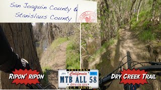
trail: Ripn' Ripon
18:11 |
383 |
Feb 16, 2021 , Ripon
Recent Trail Reports
| status | trail | date | condition | info | user |
|---|---|---|---|---|---|
| Ripn' Ripon | May 4, 2023 @ 8:25am May 4, 2023 | Ideal | Kacooper33 |
Activity Feed
| username | action | type | title | date |
|---|---|---|---|---|
| Ambrose1988 | wishlist | trail | activity #80975934 | Sep 23, 2025 @ 2:46pm Sep 23, 2025 |
| dyb2tc | vote | trail | activity #74779549 | Jun 28, 2025 @ 6:42pm Jun 28, 2025 |
| virvumjuggernaut | ridden | trail | activity #69581709 | Apr 13, 2025 @ 1:21pm Apr 13, 2025 |
| Nevrfolow | vote | trail | activity #67035939 | Mar 1, 2025 @ 6:20pm Mar 1, 2025 |
| RobertsdLa7t | ridden | trail | activity #48918409 | Feb 6, 2024 @ 9:10am Feb 6, 2024 |
Recent Comments
| username | type | title | comment | date |
|---|---|---|---|---|
| trail | Really fun! Don't be afraid of the dirt jump... | Jul 30, 2017 @ 12:28pm Jul 30, 2017 |
Activity Type Stats
| activitytype | trails | distance | descent | descent distance | total vertical | rating | global rank | state rank | photos | reports | routes | ridelogs |
|---|---|---|---|---|---|---|---|---|---|---|---|---|
| Mountain Bike | 1 | 2 miles | 341 ft | 3,829 ft | 102 ft | #8,941 | #2,846 | 12 | 6 | 3,241 | ||
| Hike | 1 | 2 miles | 341 ft | 3,829 ft | 102 ft | #15,288 | #5,590 | 6 | 72 | |||
| Trail Running | 1 | 2 miles | 341 ft | 3,829 ft | 102 ft | #14,875 | #5,358 | 6 | 4 |
- By CaptainVonAwesome
 & contributors
 - Admins: apply
- #5604 - 3,437 views
- ripon activity log | embed map of Ripon mountain bike trails |
Downloading of trail gps tracks in kml & gpx formats is enabled for Ripon.
You must login to download files.