close
-
Layers w
- Weather Layers
- Pro
- Pro
- Pro
- Pro
- Pro
- Pro
- More Layers
- Pro
- Pro
- Pro
- Pro
-
Upgrade to

3D
Trail Conditions
- Unknown
- Snow Groomed
- Snow Packed
- Snow Covered
- Snow Cover Partial
- Freeze/thaw Cycle
- Icy
- Prevalent Mud
- Wet
- Variable
- Ideal
- Dry
- Very Dry
Trail Flow (Ridden Direction)
Trailforks scans users ridelogs to determine the most popular direction each trail is ridden. A good flowing trail network will have most trails flowing in a single direction according to their intension.
The colour categories are based on what percentage of riders are riding a trail in its intended direction.
The colour categories are based on what percentage of riders are riding a trail in its intended direction.
- > 96%
- > 90%
- > 80%
- > 70%
- > 50%
- < 50%
- bi-directional trail
- no data
Trail Last Ridden
Trailforks scans ridelogs to determine the last time a trail was ridden.
- < 2 days
- < 1 week
- < 2 weeks
- < 1 month
- < 6 months
- > 6 months
Trail Ridden Direction
The intended direction a trail should be ridden.
- Downhill Only
- Downhill Primary
- Both Directions
- Uphill Primary
- Uphill Only
- One Direction
Contribute Details
Colors indicate trail is missing specified detail.
- Description
- Photos
- Description & Photos
- Videos
Trail Popularity ?
Trailforks scans ridelogs to determine which trails are ridden the most in the last 9 months.
Trails are compared with nearby trails in the same city region with a possible 25 colour shades.
Think of this as a heatmap, more rides = more kinetic energy = warmer colors.
- most popular
- popular
- less popular
- not popular
ATV/ORV/OHV Filter
Max Vehicle Width
inches
US Cell Coverage
Legend

Radar Time
Activity Recordings
Trailforks uses anonymized public activity data.
?
Activity Recordings
Trailforks uses anonymized public activity data.
?
Personal Heatmap
▶
Activity Types
all
/
none
▶
Options
2
Date range
month
–
Winter Trails
Warning
A routing network for winter maps does not exist. Selecting trails using the winter trails layer has been disabled.
Missing Trails
Most Popular
Least Popular
Trails are colored based on popularity. The more popular a trail is, the more red. Less popular trails trend towards green.
Jump Magnitude Heatmap
Heatmap of where riders jump on trails. Zoom in to see individual jumps, click circles to view jump details.
BC Backroad Status
![map legend]()
Service Road Atlas is a free to use, community-driven service for viewing and creating reports on the numerous back-country service roads around B.C. and Alberta.

Slope Aspect
Direction the slope faces
Trails Deemphasized
Trails are shown in grey.
Only show trails with no bike usage.
Suggested Layers
Based on selected activity type
Save the current map location and zoom level as your default home location whenever this page is loaded.
Save
No description for Sandnes has been added yet!
Login or register to submit one.
This region uses the Uk/Euro style trail grading system.
Activities Click to view
- Mountain Bike
35 trails
- E-Bike
4 trails
- Adaptive Bike
0 trails
- Winter Fat Bike
0 trails
- Hike
32 trails
- Trail Running
33 trails
Region Details
- 8
- 1
- 3
- 11
- 9
- 2
Region Status
Open as of Apr 8, 2026Stats
- Avg Trail Rating
- Trails (view details)
- 35
- Trails Mountain Bike
- 35
- Trails E-Bike
- 4
- Trails Horse
- 2
- Trails Hike
- 32
- Trails Trail Running
- 33
- Total Distance
- 13 miles
- Total Descent Distance
- 7 miles
- Total Descent
- 4,323 ft
- Total Vertical
- 1,128 ft
- Highest Trailhead
- 1,206 ft
- Reports
- 15
- Photos
- 7
- Ridden Counter
- 458
Sub Regions
-
Kalbergsskogen
-
Melshei
- 2
- 7
- 8
- 2
-
Vagleskogen
-
Varatun Bike Park
- 1
- 1
Popular Sandnes Mountain Biking Trails
• 100 ★ 4.5 • 1,453 ft • 0 ft • 24 •
Popular red difficulty singletrack. This mountain bike primary trail can be used downhill primary. It features berm and jump. Trail visibility is always easy to follow. On average it takes 2 minutes to complete this trail.
• 80 ★ 5.0 • 1,234 ft • 0 ft • 21 •
Heftig sti med store hopp. Intense trail with big jumps.
• 95 ★ 5.0 • 2,008 ft • 9 ft • 20 •
Popular red difficulty singletrack. This mountain bike primary trail can be used downhill only and has a moderate overall physical rating with a 9 ft green climb. It features berm and jump. Trail visibility is sometimes hard to follow. On average it takes 6 minutes to complete this trail.
• 85 ★ 0.0 • 1,014 ft • 0 ft • 19 •
Popular blue difficulty singletrack. This mountain bike primary trail can be used downhill primary and has a moderate overall physical rating with a 0 ft green climb. Trail visibility is sometimes hard to follow. On average it takes 2 minutes to complete this trail.
• 25 ★ 4.5 • 1,585 ft • 0 ft • 16 •
Less popular blue difficulty singletrack. This mountain bike primary trail can be used both directions. On average it takes 2 minutes to complete this trail.
• 85 ★ 0.0 • 971 ft • 0 ft • 15 •
Popular blue difficulty singletrack. This mountain bike primary trail can be used downhill primary. It features drop and jump. On average it takes 1 minutes to complete this trail.
• 90 ★ 0.0 • 1,322 ft • 0 ft • 14 •
Popular red difficulty singletrack. This mountain bike primary trail can be used downhill primary with a 0 ft black diamond climb. It features rock garden. Trail visibility is always easy to follow. On average it takes 1 minutes to complete this trail.
• 45 ★ 0.0 • 2,881 ft • 13 ft • 13 •
Moderately popular blue difficulty singletrack. This mountain bike primary trail can be used downhill primary and has a moderate overall physical rating with a 13 ft green climb. Trail visibility is sometimes hard to follow. On average it takes 4 minutes to complete this trail.
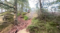
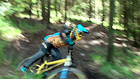
Photos of Sandnes Mountain Bike
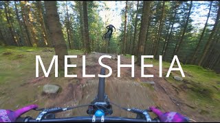
Videos of Sandnes Mountain Bike
trail: Melsheinuten rundt
0:08 |
88 |
Aug 13, 2024
trail: Stiskjo Bike Park
0:00 |
500 |
Jul 21, 2016

trail: LOOAAAMEER!
0:48 |
38 |
Oct 5, 2025 , Sandnes

trail: Magi på Sti
0:10 |
41 |
Oct 5, 2025 , Sandnes

trail: LOOAAAMEER!
12:29 |
83 |
Jul 25, 2024 , Sandnes
trail: Via Bella Badass
12:29 |
109 |
Jul 25, 2024 , Sandnes

trail: Vidkun Kvistling
12:29 |
63 |
Jul 25, 2024 , Sandnes

trail: Off The Radar
12:29 |
67 |
Jul 25, 2024 , Sandnes
Recent Trail Reports
| status | trail | date | condition | info | user |
|---|---|---|---|---|---|
| Koskenkorva | Aug 2, 2024 @ 5:58am Aug 2, 2024 | Dry | jt9021 | ||
| Parallellen | Oct 29, 2023 @ 2:00am Oct 29, 2023 | Ideal | msoyland | ||
| Via Bella Badass | Oct 29, 2023 @ 2:00am Oct 29, 2023 | Ideal | msoyland | ||
| Moon Booter | Oct 29, 2023 @ 2:00am Oct 29, 2023 | Ideal | msoyland | ||
| Grusvei | Oct 29, 2023 @ 2:00am Oct 29, 2023 | Ideal | msoyland | ||
| Trailhead Climb | Oct 29, 2023 @ 2:00am Oct 29, 2023 | Ideal | msoyland | ||
| Twister | Oct 29, 2023 @ 2:00am Oct 29, 2023 | Ideal | msoyland | ||
| Sti forbi Biskhusberget | Apr 27, 2023 @ 8:12am Apr 27, 2023 | Ideal | jt9021 | ||
| Skogaberget til skogsprett | Oct 8, 2022 @ 4:55pm Oct 8, 2022 | Wet | jt9021 | ||
| Skogaberget til parkering #2 | Oct 8, 2022 @ 4:55pm Oct 8, 2022 | Wet | jt9021 |
Activity Feed
| username | action | type | title | date |
|---|---|---|---|---|
| tilfreds | ridden | trail | activity #96068227 and 1 more | Jun 2, 2026 @ 1:21am Jun 2, 2026 |
| tilfreds | ridden | trail | activity #96068056 | Jun 2, 2026 @ 1:13am Jun 2, 2026 |
| Mekkitiz | wishlist | region | activity #95657896 | May 27, 2026 @ 1:26pm May 27, 2026 |
| ipipip71 | wishlist | region | activity #88085277 | Jan 31, 2026 @ 6:52am Jan 31, 2026 |
| ipipip71 | wishlist | trail | activity #88068948 and 2 more | Jan 30, 2026 @ 11:04pm Jan 30, 2026 |
Local Badges
-

Epic Mountain Bike Climb 2k5 awarded -

Climbing 10k Badge9 awarded -

Mountain Biking 100k Badge0 awarded -

Completionist0 awarded -

Epic Ride Descent 2k5 awarded -

Descent 10k Badge9 awarded
Bike & Skill Parks
| name | type | city | rating |
|---|---|---|---|
| Varatun Bike Park | bike park | Sandnes | |
| Sandnes sykkel- og aktivitetsgård | skill park | Sandnes | |
| Sandvedparken Pumptrack | skill park | Sandnes |
Activity Type Stats
| activitytype | trails | distance | descent | descent distance | total vertical | rating | global rank | state rank | photos | reports | routes | ridelogs |
|---|---|---|---|---|---|---|---|---|---|---|---|---|
| Mountain Bike | 35 | 13 miles | 4,321 ft | 7 miles | 1,129 ft | #4,780 | #42 | 7 | 15 | 1,957 | ||
| E-Bike | 4 | 1 mile | 266 ft | 1,414 ft | 515 ft | #2,932 | 15 | 1,315 | ||||
| Horse | 2 | 1 mile | 10 ft | 387 ft | 318 ft | #20 | ||||||
| Hike | 32 | 13 miles | 3,773 ft | 6 miles | 1,119 ft | #4,381 | #46 | 15 | 261 | |||
| Trail Running | 33 | 13 miles | 4,058 ft | 6 miles | 1,119 ft | #3,769 | #46 | 15 | 171 |
Frequently Asked Questions About Sandnes
▼
What are the best places to ride in Sandnes?
Sandnes has 4 areas to explore for mountain biking. The top rated areas are:
▼
What are the highest rated mountain biking trails in Sandnes?
The highest rated mountain biking trails in Sandnes are:
- Parallellen (4.1/5)
- Magi på Sti (4.1/5)
- Moon Booter (4.1/5)
- Vidkun Kvistling (4.1/5)
- Off The Radar (4.1/5)
▼
What is the best time of the year to ride in Sandnes?
Based on ride log data, the most popular months to ride in Sandnes are:
- September (6 activities)
- August (6 activities)
- April (4 activities)
▼
Where can I park to ride in Sandnes?
There are 10 parking locations listed in Sandnes. The most popular parking spots are: View all parking and trailhead locations on the map to plan your visit.
Trails
Points of Interest
- By buffalobilll & contributors
- Admins: apply
- #35630 - 2,591 views
- sandnes activity log | embed map of Sandnes mountain bike trails | sandnes mountain biking points of interest
Downloading of trail gps tracks in kml & gpx formats is enabled for Sandnes.
You must login to download files.