close
-
Layers w
- Weather Layers
- Pro
- Pro
- Pro
- Pro
- Pro
- Pro
- More Layers
- Pro
- Pro
- Pro
- Pro
-
Upgrade to

3D
Trail Conditions
- Unknown
- Snow Groomed
- Snow Packed
- Snow Covered
- Snow Cover Partial
- Freeze/thaw Cycle
- Icy
- Prevalent Mud
- Wet
- Variable
- Ideal
- Dry
- Very Dry
Trail Flow (Ridden Direction)
Trailforks scans users ridelogs to determine the most popular direction each trail is ridden. A good flowing trail network will have most trails flowing in a single direction according to their intension.
The colour categories are based on what percentage of riders are riding a trail in its intended direction.
The colour categories are based on what percentage of riders are riding a trail in its intended direction.
- > 96%
- > 90%
- > 80%
- > 70%
- > 50%
- < 50%
- bi-directional trail
- no data
Trail Last Ridden
Trailforks scans ridelogs to determine the last time a trail was ridden.
- < 2 days
- < 1 week
- < 2 weeks
- < 1 month
- < 6 months
- > 6 months
Trail Ridden Direction
The intended direction a trail should be ridden.
- Downhill Only
- Downhill Primary
- Both Directions
- Uphill Primary
- Uphill Only
- One Direction
Contribute Details
Colors indicate trail is missing specified detail.
- Description
- Photos
- Description & Photos
- Videos
Trail Popularity ?
Trailforks scans ridelogs to determine which trails are ridden the most in the last 9 months.
Trails are compared with nearby trails in the same city region with a possible 25 colour shades.
Think of this as a heatmap, more rides = more kinetic energy = warmer colors.
- most popular
- popular
- less popular
- not popular
ATV/ORV/OHV Filter
Max Vehicle Width
inches
US Cell Coverage
Legend

Radar Time
Activity Recordings
Trailforks uses anonymized public activity data.
?
Activity Recordings
Trailforks uses anonymized public activity data.
?
Personal Heatmap
▶
Activity Types
all
/
none
▶
Options
2
Date range
month
–
Winter Trails
Warning
A routing network for winter maps does not exist. Selecting trails using the winter trails layer has been disabled.
Missing Trails
Most Popular
Least Popular
Trails are colored based on popularity. The more popular a trail is, the more red. Less popular trails trend towards green.
Jump Magnitude Heatmap
Heatmap of where riders jump on trails. Zoom in to see individual jumps, click circles to view jump details.
BC Backroad Status
![map legend]()
Service Road Atlas is a free to use, community-driven service for viewing and creating reports on the numerous back-country service roads around B.C. and Alberta.

Slope Aspect
Direction the slope faces
Trails Deemphasized
Trails are shown in grey.
Only show trails with no bike usage.
Suggested Layers
Based on selected activity type
Save the current map location and zoom level as your default home location whenever this page is loaded.
Save
No description for Sulzano has been added yet!
Login or register to submit one.
This region uses the Uk/Euro style trail grading system.
Activities Click to view
- Mountain Bike
15 trails
- E-Bike
9 trails
- Hike
11 trails
- Trail Running
11 trails
Region Details
- 2
- 5
Region Status
Open as of Mar 21, 2026Stats
- Avg Trail Rating
- Trails (view details)
- 10
- Trails Mountain Bike
- 15
- Trails E-Bike
- 9
- Trails Hike
- 11
- Trails Trail Running
- 11
- Total Distance
- 4 miles
- Total Descent Distance
- 2 miles
- Total Descent
- 2,073 ft
- Total Vertical
- 2,393 ft
- Highest Trailhead
- 3,204 ft
- Reports
- 13
- Photos
- 3
- Ridden Counter
- 109
Popular Sulzano Mountain Biking Trails
• 80 ★ 3.0 • 1,263 ft • 0 ft • 16 •
Discesa molto vertical e tecnica da , (non esposta)
• 70 ★ 0.0 • 3,481 ft • 0 ft • 6 •
Noiosissima (in mtb) mulattiera fatta da sassi posati che porta da San Fermo a Pilzone, a piedi penso possa essere un buon sentiero in salita
• 100 ★ 0.0 • 1,640 ft • 45 ft • 6 •
Breve trail poco tecnico che permette di ricollegarsi alla discesa vertical da , la seconda metà ha qualche brevissimo passaggio da fare a spinta.
• 5 ★ 4.0 • 4,177 ft • 0 ft • 6 •
Da discesa iniziale bella verticale S3+ con alcuni passaggi molto tecnici, successivamente su sentiero molto roccioso sempre tecnico e divertente S3
• 5 ★ 0.0 • 3,337 ft • 333 ft • 6 •
Trail che sale e scende da , in salita conviene raccordarsi dal sentiero a nord, è in gran parte percorribile fino alla croce in Emtb e in parte in mtb In discesa la prima parte è un bel rockgarden poco tecnico e a metà si può...
• 90 ★ 0.0 • 1 mile • 0 ft • 4 •
La discesa dalla Punta Almana è molto scenica ma va effettuata con estrema cautela. Il primo terzo della discesa presenta numerosi passaggi molto tecnici e esposti, inoltre il fondo è molto ghiaioso e durante i periodi asciutti rende...
• 5 ★ 0.0 • 1,453 ft • 0 ft • 3 •
sentiero semplice all inizio poi ripido con scale naturali
Videos of Sulzano Mountain Bike
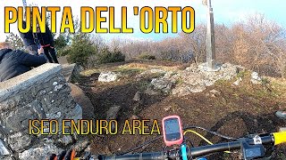
trail: Punta dell'Orto Vertical
8:32 |
129 |
May 4, 2023 , Sulzano
Recent Trail Reports
| status | trail | date | condition | info | user |
|---|---|---|---|---|---|
| Parlo | Mar 21, 2026 @ 10:39pm (Europe/Rome) Mar 21, 2026 | Dry | Albe79 | ||
| Punta dell' Orto - San Fermo | Mar 21, 2026 @ 5:54pm (Europe/Rome) Mar 21, 2026 | Dry | Albe79 | ||
| Punta dell'Orto Vertical | Mar 21, 2026 @ 5:46pm (Europe/Rome) Mar 21, 2026 | Very Dry | Albe79 | ||
| Punta dell'Orto Sud Trail | May 4, 2024 @ 1:06pm May 4, 2024 | Unknown | orobictrails-valebg | ||
| Punta dell'Orto Bassa Facile | May 4, 2024 @ 1:06pm May 4, 2024 | Unknown | orobictrails-valebg | ||
| Punta dell'Orto Easy | May 4, 2024 @ 1:06pm May 4, 2024 | Unknown | orobictrails-valebg | ||
| Cresta Sud Punta Almana | May 4, 2024 @ 1:06pm May 4, 2024 | Unknown | orobictrails-valebg |
Activity Feed
| username | action | type | title | date |
|---|---|---|---|---|
| Albe79 | add | report | activity #91027058 | Mar 21, 2026 @ 2:40pm Mar 21, 2026 |
| Albe79 | vote | trail | activity #90999880 | Mar 21, 2026 @ 9:53am Mar 21, 2026 |
| Albe79 | add | report | activity #90999409 and 1 more | Mar 21, 2026 @ 9:49am Mar 21, 2026 |
| Albe79 | difficultyvote | trail | activity #90999128 and 1 more | Mar 21, 2026 @ 9:46am Mar 21, 2026 |
| mtbbresciafederico | ridden | trail | activity #85643492 | Dec 17, 2025 @ 1:55am Dec 17, 2025 |
Recent Comments
| username | type | title | comment | date |
|---|---|---|---|---|
| trail | Der trail sollte eher rot sein. Besteht... | Aug 27, 2025 @ 11:36pm Aug 27, 2025 | ||
| trail | Der trail ist nicht in beide Richtungen zu... | Aug 27, 2025 @ 11:35pm Aug 27, 2025 | ||
| trail | Non consigliato. Pieno d'alberi caduti | Jul 2, 2025 @ 7:05am Jul 2, 2025 |
Local Badges
-

Epic Mountain Bike Climb 2k0 awarded -

Climbing 10k Badge0 awarded -

Mountain Biking 100k Badge0 awarded -

Big Ride 30k1 awarded -

Epic Ride 50k1 awarded
Activity Type Stats
| activitytype | trails | distance | descent | descent distance | total vertical | rating | global rank | state rank | photos | reports | routes | ridelogs |
|---|---|---|---|---|---|---|---|---|---|---|---|---|
| Mountain Bike | 15 | 4 miles | 2,073 ft | 2 miles | 2,392 ft | #10,220 | #1,015 | 3 | 13 | 87 | ||
| E-Bike | 9 | #10,184 | #1,100 | 6 | 23 | |||||||
| Hike | 11 | #14,430 | #1,110 | 11 | 19 | |||||||
| Trail Running | 11 | #14,278 | #1,127 | 11 | 11 |
Frequently Asked Questions About Sulzano
▼
What are the highest rated mountain biking trails in Sulzano?
The highest rated mountain biking trails in Sulzano are:
- Punta dell' Orto - San Fermo (4/5)
- Punta dell'Orto Vertical (3.8/5)
- Cresta Sud Punta Almana (0/5)
- Punta dell'Orto Sud Trail (0/5)
- Punta dell'Orto Easy (0/5)
▼
What is the best time of the year to ride in Sulzano?
Based on ride log data, the most popular months to ride in Sulzano are:
- November (1 activities)
▼
Where can I park to ride in Sulzano?
Check the Sulzano trail map for trailhead and parking information. Community members regularly update access and parking details for trails in the area.
▼
What is the longest trail in Sulzano?
The longest trail in Sulzano is Punta dell'Orto Bassa Facile at 2.8 km. View all trails sorted by distance.
Activities
Trails
Points of Interest
- By Dhreign74 & contributors
- Admins: marcoangeletti, adessoomaipiu, micheletraversi
- #46436 - 563 views
- sulzano activity log | embed map of Sulzano mountain bike trails |
Downloading of trail gps tracks in kml & gpx formats is enabled for Sulzano.
You must login to download files.