close
-
Layers w
- Weather Layers
- Pro
- Pro
- Pro
- Pro
- Pro
- Pro
- More Layers
- Pro
- Pro
- Pro
- Pro
-
Upgrade to

3D
Trail Conditions
- Unknown
- Snow Groomed
- Snow Packed
- Snow Covered
- Snow Cover Partial
- Freeze/thaw Cycle
- Icy
- Prevalent Mud
- Wet
- Variable
- Ideal
- Dry
- Very Dry
Trail Flow (Ridden Direction)
Trailforks scans users ridelogs to determine the most popular direction each trail is ridden. A good flowing trail network will have most trails flowing in a single direction according to their intension.
The colour categories are based on what percentage of riders are riding a trail in its intended direction.
The colour categories are based on what percentage of riders are riding a trail in its intended direction.
- > 96%
- > 90%
- > 80%
- > 70%
- > 50%
- < 50%
- bi-directional trail
- no data
Trail Last Ridden
Trailforks scans ridelogs to determine the last time a trail was ridden.
- < 2 days
- < 1 week
- < 2 weeks
- < 1 month
- < 6 months
- > 6 months
Trail Ridden Direction
The intended direction a trail should be ridden.
- Downhill Only
- Downhill Primary
- Both Directions
- Uphill Primary
- Uphill Only
- One Direction
Contribute Details
Colors indicate trail is missing specified detail.
- Description
- Photos
- Description & Photos
- Videos
Trail Popularity ?
Trailforks scans ridelogs to determine which trails are ridden the most in the last 9 months.
Trails are compared with nearby trails in the same city region with a possible 25 colour shades.
Think of this as a heatmap, more rides = more kinetic energy = warmer colors.
- most popular
- popular
- less popular
- not popular
ATV/ORV/OHV Filter
Max Vehicle Width
inches
US Cell Coverage
Legend

Radar Time
Activity Recordings
Trailforks uses anonymized public activity data.
?
Activity Recordings
Trailforks uses anonymized public activity data.
?
Personal Heatmap
▶
Activity Types
all
/
none
▶
Options
2
Date range
month
–
Winter Trails
Warning
A routing network for winter maps does not exist. Selecting trails using the winter trails layer has been disabled.
Missing Trails
Most Popular
Least Popular
Trails are colored based on popularity. The more popular a trail is, the more red. Less popular trails trend towards green.
Jump Magnitude Heatmap
Heatmap of where riders jump on trails. Zoom in to see individual jumps, click circles to view jump details.
BC Backroad Status
![map legend]()
Service Road Atlas is a free to use, community-driven service for viewing and creating reports on the numerous back-country service roads around B.C. and Alberta.

Slope Aspect
Direction the slope faces
Trails Deemphasized
Trails are shown in grey.
Only show trails with no bike usage.
Suggested Layers
Based on selected activity type
Save the current map location and zoom level as your default home location whenever this page is loaded.
Save
No description for Superga has been added yet!
Login or register to submit one.
 google parking directions
Primary Trail Type: Cross-Country
Shuttleable: YES
google parking directionsThis region uses the Uk/Euro style trail grading system.
Activities Click to view
- Mountain Bike
44 trails
- E-Bike
28 trails
- Hike
38 trails
- Trail Running
38 trails
Region Details
- 3
- 1
- 23
- 14
Region Status
Caution as of May 14, 2026Stats
- Avg Trail Rating
- Trails (view details)
- 42
- Trails Mountain Bike
- 45
- Trails E-Bike
- 28
- Trails Hike
- 38
- Trails Trail Running
- 38
- Total Distance
- 31 miles
- Total Descent
- 13,533 ft
- Total Vertical
- 1,521 ft
- Highest Trailhead
- 2,203 ft
- Reports
- 1,083
- Photos
- 25
- Ridden Counter
- 5,287
Popular Superga Mountain Biking Trails
• 95 ★ 4.2 • 1,788 ft • 0 ft • 265 •
Medium difficult trail, very fast and a little broken in some point
• 90 ★ 4.7 • 1 mile • 18 ft • 263 •
Funny trail with lot of curves and uphill sections. The last part could be easily muddy in some points.
• 65 ★ 5.0 • 1 mile • 15 ft • 170 •
Sentiero Flow Salti e Sponde uno dei più belli della zona di Superga
• 85 ★ 4.0 • 2,103 ft • 56 ft • 166 •
Popular green difficulty singletrack. This multi-use trail can be used both directions. On average it takes 2 minutes to complete this trail.
• 85 ★ 4.3 • 2,175 ft • 30 ft • 163 •
Popular green difficulty family friendly singletrack. This multi-use trail can be used downhill primary and has a easy overall physical rating with a 30 ft green climb. It features roller coaster. Trail visibility is always easy to follow. On average it takes 3 minutes to complete this trail.
• 85 ★ 5.0 • 3,734 ft • 30 ft • 162 •
Fondo scorrevole in terra compatta, pendenze contenute e qualche rilancio. Ottimo per principianti.
• 90 ★ 4.0 • 4,879 ft • 346 ft • 150 •
Popular blue difficulty singletrack. This mountain bike primary trail can be used both directions. On average it takes 11 minutes to complete this trail.
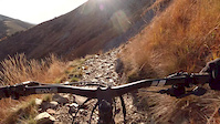
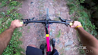
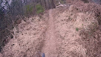
Photos of Superga Mountain Bike
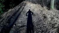
Videos of Superga Mountain Bike


Recent Trail Reports
| status | trail | date | condition | info | user |
|---|---|---|---|---|---|
| 600XL | May 14, 2026 @ 12:55pm (Europe/Rome) May 14, 2026 | Ideal | andrereve | ||
| 26 to Orrido | May 14, 2026 @ 12:55pm (Europe/Rome) May 14, 2026 | Ideal | andrereve | ||
| Variante salita 26 | May 14, 2026 @ 12:55pm (Europe/Rome) May 14, 2026 | Ideal | andrereve | ||
| Galleria Rocca | Apr 23, 2026 @ 1:44pm (Europe/Rome) Apr 23, 2026 | Unknown | andrereve | ||
| 100 Croci | Apr 21, 2026 @ 1:17pm (Europe/Monaco) Apr 21, 2026 | Ideal | andrereve | ||
| 600 down | Apr 1, 2026 @ 2:07pm (Europe/Monaco) Apr 1, 2026 | Dry | TheCount77 | ||
| Basilica | Nov 23, 2025 @ 3:49pm (Europe/Rome) Nov 23, 2025 | Variable | maxresolution | ||
| Rosmarino 1 | Nov 23, 2025 @ 9:28am (Europe/Rome) Nov 23, 2025 | Ideal | andrereve | ||
| Calcetano | Nov 23, 2025 @ 9:28am (Europe/Rome) Nov 23, 2025 | Ideal | andrereve | ||
| Bob | Nov 23, 2025 @ 9:28am (Europe/Rome) Nov 23, 2025 | Ideal | andrereve |
Activity Feed
| username | action | type | title | date |
|---|---|---|---|---|
| andrereve | add | report | activity #94684978 and 2 more | May 14, 2026 @ 6:22am May 14, 2026 |
| toprakdgjwUV | ridden | trail | activity #94483783 | May 11, 2026 @ 2:15am May 11, 2026 |
| Alberto0WWowx | ridden | trail | activity #93349773 | Apr 25, 2026 @ 6:36am Apr 25, 2026 |
| andrereve | add | report | activity #93209806 | Apr 23, 2026 @ 6:42am Apr 23, 2026 |
| andrereve | add | report | activity #93075241 | Apr 21, 2026 @ 6:03am Apr 21, 2026 |
Recent Comments
| username | type | title | comment | date |
|---|---|---|---|---|
| report | Ma si riesce a deviare, il resto é... | Mar 20, 2025 @ 9:18am Mar 20, 2025 | ||
| trail | Fun downhill with lots of steep berms. Last... | Jan 28, 2024 @ 2:51am Jan 28, 2024 | ||
| report | This trail could be rided with gravel bike. | Sep 18, 2023 @ 2:04am Sep 18, 2023 | ||
| trail | Andato ieri giovedì 8 dicembre. Da poco prima... | Dec 9, 2022 @ 9:08am Dec 9, 2022 | ||
| trail | Prevalentemente scassato con fondo composto... | Nov 14, 2022 @ 1:22pm Nov 14, 2022 |
Nearby Areas
| name | distance | ||||
|---|---|---|---|---|---|
| Cordova | 4 | 7 | 2.3 km | ||
| Osservatorio | 7 | 2 | 3 km | ||
| Colle della Maddalena | 14 | 14 | 2 | 4.5 km | |
| Bosco del Vaj e Bosc Grand | 33 | 17 | 1 | 7.8 km | |
| Castelnuovo Don Bosco Trails | 8 | 1 | 8.2 km |
Local Badges
-

Completionist0 awarded
Activity Type Stats
| activitytype | trails | distance | descent | descent distance | total vertical | rating | global rank | state rank | photos | reports | routes | ridelogs |
|---|---|---|---|---|---|---|---|---|---|---|---|---|
| Mountain Bike | 44 | 31 miles | 13,533 ft | 19 miles | 1,522 ft | #2,302 | #85 | 25 | 1,083 | 9,170 | ||
| E-Bike | 28 | 14 miles | 3,760 ft | 7 miles | 1,345 ft | #463 | #63 | 1,007 | 2,284 | |||
| Hike | 38 | 29 miles | 13,379 ft | 19 miles | 1,522 ft | #5,257 | #158 | 1,081 | 67 | |||
| Trail Running | 38 | 29 miles | 13,379 ft | 19 miles | 1,522 ft | #4,293 | #146 | 1,081 | 125 |
Frequently Asked Questions About Superga
▼
What are the highest rated mountain biking trails in Superga?
The highest rated mountain biking trails in Superga are:
- Calcetano (4.6/5)
- 600XL (4.4/5)
- 61 (4.3/5)
- 1° taglio (4.1/5)
- 29 drop line (4.1/5)
▼
What is the best time of the year to ride in Superga?
Based on ride log data, the most popular months to ride in Superga are:
- October (44 activities)
- April (39 activities)
- March (33 activities)
▼
Where can I park to ride in Superga?
There are 2 parking locations listed in Superga. The most popular parking spots are:
▼
What is the longest trail in Superga?
The longest trail in Superga is 26 at 4.9 km. View all trails sorted by distance.
Activities
- By beppovox & contributors
- Admins: apply
- #4322 - 5,738 views
- superga activity log | embed map of Superga mountain bike trails | superga mountain biking points of interest
Downloading of trail gps tracks in kml & gpx formats is enabled for Superga.
You must login to download files.