close
-
Layers w
- Weather Layers
- Pro
- Pro
- Pro
- Pro
- Pro
- Pro
- More Layers
- Pro
- Pro
- Pro
- Pro
-
Upgrade to

3D
Trail Conditions
- Unknown
- Snow Groomed
- Snow Packed
- Snow Covered
- Snow Cover Partial
- Freeze/thaw Cycle
- Icy
- Prevalent Mud
- Wet
- Variable
- Ideal
- Dry
- Very Dry
Trail Flow (Ridden Direction)
Trailforks scans users ridelogs to determine the most popular direction each trail is ridden. A good flowing trail network will have most trails flowing in a single direction according to their intension.
The colour categories are based on what percentage of riders are riding a trail in its intended direction.
The colour categories are based on what percentage of riders are riding a trail in its intended direction.
- > 96%
- > 90%
- > 80%
- > 70%
- > 50%
- < 50%
- bi-directional trail
- no data
Trail Last Ridden
Trailforks scans ridelogs to determine the last time a trail was ridden.
- < 2 days
- < 1 week
- < 2 weeks
- < 1 month
- < 6 months
- > 6 months
Trail Ridden Direction
The intended direction a trail should be ridden.
- Downhill Only
- Downhill Primary
- Both Directions
- Uphill Primary
- Uphill Only
- One Direction
Contribute Details
Colors indicate trail is missing specified detail.
- Description
- Photos
- Description & Photos
- Videos
Trail Popularity ?
Trailforks scans ridelogs to determine which trails are ridden the most in the last 9 months.
Trails are compared with nearby trails in the same city region with a possible 25 colour shades.
Think of this as a heatmap, more rides = more kinetic energy = warmer colors.
- most popular
- popular
- less popular
- not popular
ATV/ORV/OHV Filter
Max Vehicle Width
inches
US Cell Coverage
Legend

Radar Time
Activity Recordings
Trailforks uses anonymized public activity data.
?
Activity Recordings
Trailforks uses anonymized public activity data.
?
Personal Heatmap
▶
Activity Types
all
/
none
▶
Options
2
Date range
month
–
Winter Trails
Warning
A routing network for winter maps does not exist. Selecting trails using the winter trails layer has been disabled.
Missing Trails
Most Popular
Least Popular
Trails are colored based on popularity. The more popular a trail is, the more red. Less popular trails trend towards green.
Jump Magnitude Heatmap
Heatmap of where riders jump on trails. Zoom in to see individual jumps, click circles to view jump details.
BC Backroad Status
![map legend]()
Service Road Atlas is a free to use, community-driven service for viewing and creating reports on the numerous back-country service roads around B.C. and Alberta.

Slope Aspect
Direction the slope faces
Trails Deemphasized
Trails are shown in grey.
Only show trails with no bike usage.
Suggested Layers
Based on selected activity type
Save the current map location and zoom level as your default home location whenever this page is loaded.
Save
No description for Tehran has been added yet!
Login or register to submit one.
Activities Click to view
- Mountain Bike
7 trails
- E-Bike
2 trails
- Hike
8 trails
- Trail Running
7 trails
Region Details
- 4
- 3
Region Status
Open as of Jul 2, 2021Stats
- Avg Trail Rating
- Trails (view details)
- 7
- Trails Mountain Bike
- 7
- Trails E-Bike
- 2
- Trails Hike
- 8
- Trails Trail Running
- 7
- Total Distance
- 23 miles
- Total Descent
- 6,911 ft
- Total Vertical
- 4,718 ft
- Highest Trailhead
- 8,493 ft
- Reports
- 1
- Photos
- 5
- Ridden Counter
- 21
Articles
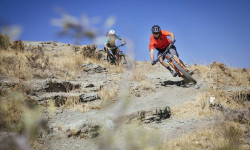
Neethling & Meyer in Iran - Chasing Trail Ep. 19
Mar 16, 2018 from pinkbike.com
Andrew Neethling and Holger Meyer head to Iran and ride the country's top-notch trail network.
Sub Regions
-
Lavasanat
-
Sorkheh Hesar
- 2
- 2
Popular Tehran Mountain Biking Trails
• 5 ★ 4.0 • 3 miles • 125 ft • 7 •
You have to walk your bike up the trail by foot........... Then you have a long singletrack back the way down..............with all of natural stuff and some man made stuff too............ Small Rocky drops.........rock...
• 5 ★ 0.0 • 4 miles • 290 ft • 1 •
This route is one of the oldest paths located at north of Tehran. Palangchal is a mountain hut and an access path to Fifth Station of Tochal cabin. It is one the most favourite hiking trails in the mountains of Tehran with a lot of Tea...
• 5 ★ 5.0 • 3 miles • 2,660 ft • 1 •
A main hiking path in northTehran mountains, Kolakchal trail was made in 1970's for scout groups and all nature lovers. Still in use for hiking and recently used for biking as well, although you are only allowed to bike midweek and...
• 5 ★ 0.0 • 4,287 ft • 8 ft • 1 •
Less popular blue difficulty singletrack. This mountain bike primary trail can be used downhill primary with a 8 ft black diamond climb.
• 5 ★ 0.0 • 11 miles • 3,099 ft •
Less popular blue difficulty singletrack. This mountain bike primary trail can be used uphill primary.
• 5 ★ 0.0 • 4,297 ft • 10 ft •
Less popular blue difficulty singletrack. This mountain bike primary trail can be used downhill primary and has a moderate overall physical rating with a 10 ft black diamond climb. It features berm, drop and rock face.
• 5 ★ 0.0 • 3,742 ft • 5 ft •
Less popular black diamond difficulty singletrack. This mountain bike primary trail can be used downhill primary and has a hard overall physical rating with a 5 ft blue climb. It features drop, jump, rock face and rock garden.
Recent Trail Reports
| status | trail | date | condition | info | user |
|---|---|---|---|---|---|
| Kolakchal Normal Path | Jul 11, 2019 @ 9:36am Jul 11, 2019 | Dry | E-BOY |
Activity Feed
| username | action | type | title | date |
|---|---|---|---|---|
| HassanSglqAB | ridden | trail | activity #85782707 | Dec 20, 2025 @ 7:30am Dec 20, 2025 |
| RezaKRsfOO | add | directory | activity #31792676 | Jul 25, 2022 @ 4:46pm Jul 25, 2022 |
| nimajneb | like | directory | activity #16483969 | Feb 7, 2021 @ 10:00pm Feb 7, 2021 |
| alpha-line | wishlist | trail | activity #7851431 and 2 more | Jan 12, 2020 @ 8:44pm Jan 12, 2020 |
| alpha-line | wishlist | trail | activity #7851425 and 3 more | Jan 12, 2020 @ 8:43pm Jan 12, 2020 |
Recent Comments
| username | type | title | comment | date |
|---|---|---|---|---|
| trail | ایشالا که چیزی نشه | Jul 23, 2015 @ 3:19am Jul 23, 2015 | ||
| trail | ترجیح می دادیم این مسیر... | Feb 2, 2015 @ 3:14pm Feb 2, 2015 |
Local Mountain Biking Directory
-
Saba Docharkh
-
Bike Boutique
![Bike Boutique]()
-
Saber-mtbBike Shop
-
Saber MtbBike Shop
-
Jn ShopBike Shop
Activity Type Stats
| activitytype | trails | distance | descent | descent distance | total vertical | rating | global rank | state rank | photos | reports | routes | ridelogs |
|---|---|---|---|---|---|---|---|---|---|---|---|---|
| Mountain Bike | 7 | 23 miles | 6,909 ft | 12 miles | 4,718 ft | #3,193 | #2 | 4 | 1 | 1,269 | ||
| E-Bike | 2 | 7 miles | 2,956 ft | 4 miles | 2,927 ft | #1,687 | #1 | 1 | 49 | |||
| Hike | 8 | 23 miles | 6,909 ft | 12 miles | 4,718 ft | #2,135 | #1 | 1 | 1 | 75 | ||
| Trail Running | 7 | 23 miles | 6,909 ft | 12 miles | 4,718 ft | #1,677 | #1 | 1 | 24 |
Frequently Asked Questions About Tehran
▼
What are the best places to ride in Tehran?
Tehran has 2 areas to explore for mountain biking. The top rated areas are:
▼
What are the highest rated mountain biking trails in Tehran?
The highest rated mountain biking trails in Tehran are:
- Kolakchal Normal Path (4.1/5)
- Enduro (4/5)
- Palangchal to Darakeh (0/5)
- Haroon (0/5)
- Bein Al masirain (0/5)
▼
What is the best time of the year to ride in Tehran?
Based on ride log data, the most popular months to ride in Tehran are:
- July (2 activities)
- October (1 activities)
- August (1 activities)
▼
Where can I park to ride in Tehran?
Check the Tehran trail map for trailhead and parking information. Community members regularly update access and parking details for trails in the area.
Trails
Points of Interest
- By msafdel & contributors
- Admins: apply
- #7427 - 5,137 views
- tehran activity log | embed map of Tehran mountain bike trails | tehran mountain biking points of interest
Downloading of trail gps tracks in kml & gpx formats is enabled for Tehran.
You must login to download files.