close
-
Layers w
- Weather Layers
- Pro
- Pro
- Pro
- Pro
- Pro
- Pro
- More Layers
- Pro
- Pro
- Pro
- Pro
-
Upgrade to

3D
Trail Conditions
- Unknown
- Snow Groomed
- Snow Packed
- Snow Covered
- Snow Cover Partial
- Freeze/thaw Cycle
- Icy
- Prevalent Mud
- Wet
- Variable
- Ideal
- Dry
- Very Dry
Trail Flow (Ridden Direction)
Trailforks scans users ridelogs to determine the most popular direction each trail is ridden. A good flowing trail network will have most trails flowing in a single direction according to their intension.
The colour categories are based on what percentage of riders are riding a trail in its intended direction.
The colour categories are based on what percentage of riders are riding a trail in its intended direction.
- > 96%
- > 90%
- > 80%
- > 70%
- > 50%
- < 50%
- bi-directional trail
- no data
Trail Last Ridden
Trailforks scans ridelogs to determine the last time a trail was ridden.
- < 2 days
- < 1 week
- < 2 weeks
- < 1 month
- < 6 months
- > 6 months
Trail Ridden Direction
The intended direction a trail should be ridden.
- Downhill Only
- Downhill Primary
- Both Directions
- Uphill Primary
- Uphill Only
- One Direction
Contribute Details
Colors indicate trail is missing specified detail.
- Description
- Photos
- Description & Photos
- Videos
Trail Popularity ?
Trailforks scans ridelogs to determine which trails are ridden the most in the last 9 months.
Trails are compared with nearby trails in the same city region with a possible 25 colour shades.
Think of this as a heatmap, more rides = more kinetic energy = warmer colors.
- most popular
- popular
- less popular
- not popular
ATV/ORV/OHV Filter
Max Vehicle Width
inches
US Cell Coverage
Legend

Radar Time
Activity Recordings
Trailforks uses anonymized public activity data.
?
Activity Recordings
Trailforks uses anonymized public activity data.
?
Personal Heatmap
▶
Activity Types
all
/
none
▶
Options
2
Date range
month
–
Winter Trails
Warning
A routing network for winter maps does not exist. Selecting trails using the winter trails layer has been disabled.
Missing Trails
Most Popular
Least Popular
Trails are colored based on popularity. The more popular a trail is, the more red. Less popular trails trend towards green.
Jump Magnitude Heatmap
Heatmap of where riders jump on trails. Zoom in to see individual jumps, click circles to view jump details.
BC Backroad Status
![map legend]()
Service Road Atlas is a free to use, community-driven service for viewing and creating reports on the numerous back-country service roads around B.C. and Alberta.

Slope Aspect
Direction the slope faces
Trails Deemphasized
Trails are shown in grey.
Only show trails with no bike usage.
Suggested Layers
Based on selected activity type
Save the current map location and zoom level as your default home location whenever this page is loaded.
Save
No description for Voltri has been added yet!
Login or register to submit one.
This region uses the Uk/Euro style trail grading system.
Activities Click to view
- Mountain Bike
6 trails
- E-Bike
7 trails
- Hike
2 trails
- Trail Running
2 trails
Region Details
- 1
- 3
Region Status
Open as of May 16, 2026Stats
- Avg Trail Rating
- Trails (view details)
- 5
- Trails Mountain Bike
- 7
- Trails E-Bike
- 7
- Trails Hike
- 2
- Trails Trail Running
- 2
- Total Distance
- 3,563 ft
- Total Descent Distance
- 3,330 ft
- Total Descent
- 561 ft
- Total Vertical
- 555 ft
- Highest Trailhead
- 2,013 ft
- Reports
- 20
- Photos
- 26
- Ridden Counter
- 487
Popular Voltri Mountain Biking Trails
• 5 ★ 5.0 • 3,563 ft • 6 ft • 12 •
Single track starting from Cian de' Figge descending on the right side of the hill towards Prà. The track ends on the crossroads connecting Colla di Pra', Fagaglia, Cian de Figge and Fossa del Lupo. The trail is funny and not too much...
• ★ 5.0 • 2,907 ft • 8 ft • 7 •
Flow Trail molto veloce e che alla fine si ricollega al New Branega
• ★ 0.0 • 1,955 ft • 0 ft • 1 •
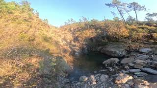
Single track alpinistico a tratti, fondo tipico ligure, poca vegetazione, panorama stupendo. Sentiero molto bello che si collega alle Lische alte a scendere per proseguire fino alla colla di pra, una bella discesa di 1.6 km.
• ★ 0.0 • 3,999 ft • 94 ft •
Singletrack tecnico la parte alta, la seconda parte più aperto. Paesaggio stupendo, si passa da un laghetto che sempre una piscina naturale, stupendo.
Voltri Mountain Bike Routes
13 miles • 4,092 ft • 9 • Loop •
Bel giro che dalla prima collina di Pegli porta fino a 700 mt a CIan De Figgie. Percorso non semplice che...
Photos of Voltri Mountain Bike
Videos of Voltri Mountain Bike
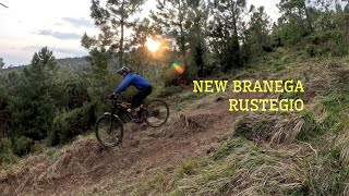
trail: RuSteGio Trail
6:59 |
20 |
Mar 22, 2026 , Voltri
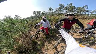
trail: RuSteGio Trail
3:45 |
60 |
Mar 9, 2026 , Voltri
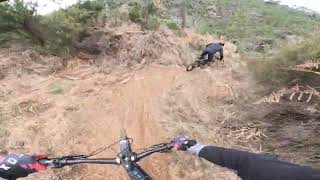
trail: RuSteGio Trail
3:56 |
26 |
Feb 23, 2026 , Voltri
trail: Colla Arullo Rock
8:06 |
31 |
Nov 18, 2025 , Voltri
trail: Baiarda Trail
10:06 |
34 |
Nov 18, 2025 , Voltri
Recent Trail Reports
| status | trail | date | condition | info | user |
|---|---|---|---|---|---|
| Exit Branega | May 17, 2026 @ 8:34am (Europe/Rome) May 16, 2026 | Ideal | danilo959 | ||
| RuSteGio Trail | Apr 28, 2026 @ 7:57am (Europe/Rome) Apr 27, 2026 | Ideal | danilo959 | ||
| Access to Rustegio | Feb 28, 2026 @ 8:47am (Europe/Rome) Feb 27, 2026 | Unknown | danilo959 | ||
| Colla Arullo Rock | Nov 17, 2025 @ 2:10pm (Europe/Rome) Nov 17, 2025 | Unknown | AR9 | ||
| Highway to Pra' | Dec 28, 2024 @ 8:18am Dec 28, 2024 | Ideal | danilo959 |
Activity Feed
| username | action | type | title | date |
|---|---|---|---|---|
| danilo959 | add | report | activity #94914761 | May 17, 2026 @ 9:48am May 17, 2026 |
| danilo959 | add | report | activity #94317345 | May 9, 2026 @ 1:45am May 9, 2026 |
| danilo959 | add | report | activity #93587661 | Apr 28, 2026 @ 9:50am Apr 28, 2026 |
| danilo959 | add | report | activity #92254048 and 1 more | Apr 9, 2026 @ 8:11am Apr 9, 2026 |
| AR9 | add | video | activity #91110471 | Mar 22, 2026 @ 2:30pm Mar 22, 2026 |
Recent Comments
| username | type | title | comment | date |
|---|---|---|---|---|
| trail | Perfetto, mancano solo alcuni inviti sugli scoli | Feb 23, 2026 @ 2:06pm Feb 23, 2026 | ||
| trail | Perfetto, mancano alcuni inviti sugli scoli | Feb 23, 2026 @ 1:59pm Feb 23, 2026 | ||
| trail | Ciao come si fa ad arrivare all'inizio del... | Dec 21, 2025 @ 11:38am Dec 21, 2025 | ||
| trail | Sentiero molto bello che si collega alle... | Nov 18, 2025 @ 1:46am Nov 18, 2025 | ||
| trail | prima parte hard rock, panorama stupendo | Nov 17, 2025 @ 5:14am Nov 17, 2025 |
Local Badges
-

Epic Mountain Bike Climb 2k2 awarded -

Climbing 10k Badge0 awarded -

Mountain Biking 100k Badge0 awarded -

Epic Ride 50k8 awarded
Activity Type Stats
| activitytype | trails | distance | descent | descent distance | total vertical | rating | global rank | state rank | photos | reports | routes | ridelogs |
|---|---|---|---|---|---|---|---|---|---|---|---|---|
| Mountain Bike | 6 | 3,563 ft | 561 ft | 3,330 ft | 554 ft | #5,238 | #382 | 26 | 20 | 2 | 241 | |
| E-Bike | 7 | 3,563 ft | 561 ft | 3,330 ft | 554 ft | #8,818 | #965 | 20 | 1 | 47 | ||
| Hike | 2 | #14,430 | #1,106 | 16 | 29 | |||||||
| Trail Running | 2 | #14,058 | #1,110 | 16 | 4 |
- By paolocanavese
 & contributors
 - Admins: denitopia, linomak
- #20154 - 2,368 views
- voltri activity log | embed map of Voltri mountain bike trails |
Downloading of trail gps tracks in kml & gpx formats is enabled for Voltri.
You must login to download files.