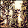
- Trail:
- Pit Party (University Hill)
- Status:
- Minor Issue / Yellow
-
Issue status:
- Condition:
- Wet - wet & tacky, likelihood of mud, be kind to trails
- Reporter Primary Activity:
- Mountain Bike
Description:
Thanks to the kick ass group of random rakers who scrubbed the trail clean top to bottom! The trail is clear but pretty slick in areas with all the wet weather we have been having.
The Token Rock zone is complete and ready to ride - not a wet day feature so here's hoping for another few dry days! The second jump is pretty to look at but has an attitude problem. It's doable but a bit of a buzz kill. Using vastly complex scientific methods of consuming beer and staring at things, I've determined it's simply in the wrong spot. While I'm shuffling it around next week the Token Rock hip gap will remain open and ridable. Chances are it will be rebuilt before we get another couple dry days to ride anyways ~ cheers
The Token Rock zone is complete and ready to ride - not a wet day feature so here's hoping for another few dry days! The second jump is pretty to look at but has an attitude problem. It's doable but a bit of a buzz kill. Using vastly complex scientific methods of consuming beer and staring at things, I've determined it's simply in the wrong spot. While I'm shuffling it around next week the Token Rock hip gap will remain open and ridable. Chances are it will be rebuilt before we get another couple dry days to ride anyways ~ cheers
close
-
Layers w
- Weather Layers
- Pro
- Pro
- Pro
- Pro
- Pro
- Pro
- More Layers
- Pro
- Pro
- Pro
- Pro
-
Upgrade to

3D
Trail Conditions
- Unknown
- Snow Groomed
- Snow Packed
- Snow Covered
- Snow Cover Partial
- Freeze/thaw Cycle
- Icy
- Prevalent Mud
- Wet
- Variable
- Ideal
- Dry
- Very Dry
Trail Flow (Ridden Direction)
Trailforks scans users ridelogs to determine the most popular direction each trail is ridden. A good flowing trail network will have most trails flowing in a single direction according to their intension.
The colour categories are based on what percentage of riders are riding a trail in its intended direction.
The colour categories are based on what percentage of riders are riding a trail in its intended direction.
- > 96%
- > 90%
- > 80%
- > 70%
- > 50%
- < 50%
- bi-directional trail
- no data
Trail Last Ridden
Trailforks scans ridelogs to determine the last time a trail was ridden.
- < 2 days
- < 1 week
- < 2 weeks
- < 1 month
- < 6 months
- > 6 months
Trail Ridden Direction
The intended direction a trail should be ridden.
- Downhill Only
- Downhill Primary
- Both Directions
- Uphill Primary
- Uphill Only
- One Direction
Contribute Details
Colors indicate trail is missing specified detail.
- Description
- Photos
- Description & Photos
- Videos
Trail Popularity ?
Trailforks scans ridelogs to determine which trails are ridden the most in the last 9 months.
Trails are compared with nearby trails in the same city region with a possible 25 colour shades.
Think of this as a heatmap, more rides = more kinetic energy = warmer colors.
- most popular
- popular
- less popular
- not popular
ATV/ORV/OHV Filter
Max Vehicle Width
inches
US Cell Coverage
Legend

Radar Time
Activity Recordings
Trailforks uses anonymized public activity data.
?
Activity Recordings
Trailforks uses anonymized public activity data.
?
Personal Heatmap
▶
Activity Types
all
/
none
▶
Options
2
Date range
month
–
Winter Trails
Warning
A routing network for winter maps does not exist. Selecting trails using the winter trails layer has been disabled.
Missing Trails
Most Popular
Least Popular
Trails are colored based on popularity. The more popular a trail is, the more red. Less popular trails trend towards green.
Jump Magnitude Heatmap
Heatmap of where riders jump on trails. Zoom in to see individual jumps, click circles to view jump details.
BC Backroad Status
![map legend]()
Service Road Atlas is a free to use, community-driven service for viewing and creating reports on the numerous back-country service roads around B.C. and Alberta.

Slope Aspect
Direction the slope faces
Trails Deemphasized
Trails are shown in grey.
Only show trails with no bike usage.
Suggested Layers
Based on selected activity type
Save the current map location and zoom level as your default home location whenever this page is loaded.
SaveCoordinates: 53.893237, -122.806721
 campbell-TOE
Oct 26, 2014 at 15:06
campbell-TOE
Oct 26, 2014 at 15:06
