- Trail:
- Espresso (Food Network)
- Status:
- Significant Issue / Amber
-
Issue status: Complete
Assigned user: joshuatfoote
Complete Aug 4, 2026 @ 6:33am Bridge has been replaced joshuatfoote In progress Aug 4, 2026 @ 6:32am Bridge Replacement Planned joshuatfoote Open Aug 4, 2026 @ 6:31am Please repair WillieJacobsz Open Nov 21, 2025 @ 1:55pm Bridge replaced in October Bobshalit Open Jun 10, 2025 @ 6:39am bridge should now be considered unridable - it has continued to settle with stringers sinking - I'm not sure it should even be walked over - potential for catastrophic failure. Bobshalit Open Jun 10, 2025 @ 6:36am Bobshalit - Condition:
- Ideal - Hero dirt! Not wet but not dry, moisture in soil.
- Reporter Primary Activity:
- Mountain Bike
Description:
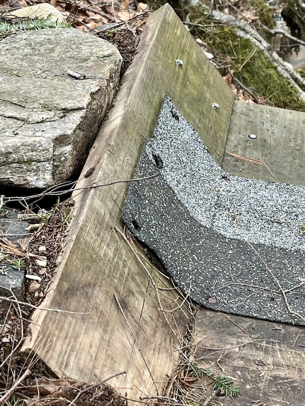
Big curved bridge over creek after Espresso - dangerous! Rotten, broken plank in middle, but most dangerous, at the very end of bridge, the last 2 x 8 plank is sticking nearly straight up like a wall and not at all obvious (the rails are failing). Hitting that plank at speed I nearly bottomed out my fork and made it over having lost nearly all my speed and came to a stop as I didn’t realize what I’d hit. If somebody didn’t make it over, or stopped just after hitting that plank, could likely fall off the embankment into the creek, a rocky 7 or 8 foot vertical drop. .
close
-
Layers w
- Weather Layers
- Pro
- Pro
- Pro
- Pro
- Pro
- Pro
- More Layers
- Pro
- Pro
- Pro
- Pro
-
Upgrade to

3D
Trail Conditions
- Unknown
- Snow Groomed
- Snow Packed
- Snow Covered
- Snow Cover Partial
- Freeze/thaw Cycle
- Icy
- Prevalent Mud
- Wet
- Variable
- Ideal
- Dry
- Very Dry
Trail Flow (Ridden Direction)
Trailforks scans users activity logs to determine the most popular direction each trail is ridden. A good flowing trail network will have most trails flowing in a single direction according to their intension.
The colour categories are based on what percentage of users are riding a trail in its intended direction.
The colour categories are based on what percentage of users are riding a trail in its intended direction.
- > 96%
- > 90%
- > 80%
- > 70%
- > 50%
- < 50%
- bi-directional trail
- no data
Trail Last Used
Trailforks scans activity logs to determine the last time a trail was ridden.
- < 2 days
- < 1 week
- < 2 weeks
- < 1 month
- < 6 months
- > 6 months
Trail Ridden Direction
The intended direction a trail should be ridden.
- Downhill Only
- Downhill Primary
- Both Directions
- Uphill Primary
- Uphill Only
- One Direction
Contribute Details
Colors indicate trail is missing specified detail.
- Description
- Photos
- Description & Photos
- Videos
Trail Popularity ?
Trailforks scans activity logs to determine which trails are ridden the most in the last 9 months.
Trails are compared with nearby trails in the same city region with a possible 25 colour shades.
Think of this as a heatmap, more activities = more kinetic energy = warmer colors.
- most popular
- popular
- less popular
- not popular
ATV/ORV/OHV Filter
Max Vehicle Width
inches
US Cell Coverage
Legend

Radar Time
Activity Recordings
Trailforks uses anonymized public activity data.
?
Activity Recordings
Trailforks uses anonymized public activity data.
?
Winter Trails
Warning
A routing network for winter maps does not exist. Selecting trails using the winter trails layer has been disabled.
Missing Trails
Most Popular
Least Popular
Trails are colored based on popularity. The more popular a trail is, the more red. Less popular trails trend towards green.
Jump Magnitude Heatmap
Heatmap of where users jump on trails. Zoom in to see individual jumps, click circles to view jump details.
BC Backroad Status
![map legend]()
Service Road Atlas is a free to use, community-driven service for viewing and creating reports on the numerous back-country service roads around B.C. and Alberta.

Slope Aspect
Direction the slope faces
Trails Deemphasized
Trails are shown in grey.
Only show trails with no bike usage.
Suggested Layers
Based on selected activity type
Save the current map location and zoom level as your default home location whenever this page is loaded.
SaveCoordinates: 42.974400, -72.346772
Local Weather During Report
- Summary
Cloudy - Temperature
3° (0°/5°) - Precip
0.02 mm/h - Wind
10.45 km/h - Cloud Cover
100% - Humidity
0.83
Previous Reports
2 Comments
- + 0
Bobshalit
Nov 21, 2025 at 13:54
Nope never done ridden one of them kinda contraptions before and my shit don’t stink either ‘cause I been smelling it so long I’ve come to like it! The bridge failed nearly catostrophically and was completely replaced in October by the BK-NEMBA club of which I’m a co-founder.