


Open in App
Get this route on your phone instantly.
Climb up Elden Lookout Road from the Schultz "Y" trailhead parking lot.
There is an option a couple of miles up the road to hop on some single track that parallels the road called Middle Oldham, but if you want to just plug along, you can continue up the road and that's faster.
You'll hop on Sunset Trail (option to continue a little farther to the very top of Sunset up the road a little). That section at the top is pretty janky, but fun and the views are great so its your choice.
Climb the little knoll up the ridge and begin the "Catwalk." Narrow, but nothing too spicy so you should be fine. You'll drop into a section of the trail nicknamed "Hobbit's Forest" right after you pass the Hart Trail intersection. It gets technical and rocky in here, lots of fun lines through. Once you're out of the boulder garden you'll have a fun fast section to an intersection with Little Bear and Sunset continues up. Climb up to the top of the ridge (this section is a bit steep but not awful - approx. 15 min max of climbing). Then descend one of my favorite sections. The beginning is wide turns but once you get a little farther down, it gets crazy fast, deep in the trees - this section is called Warp Rider.
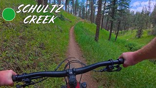
You'll hit the Schultz Trailhead. You can either descend Schultz Creek at this point, which is a LOT of fun, or for a bonus you can climb up into the Dry Lake Hill via Broadside and hit a trail that's been re-routed called Jedi/Lunar Tide. It drops you back into Schultz a little below the trailhead soyou don't miss much of it.
Then rip back down to the parking lot 

We hope you've been enjoying Trailforks!
Create a FREE account to view all route reviews and much more.
| 1,759 ft | |||||
| 1 mile | |||||
| 3 miles |

Service Road Atlas is a free to use, community-driven service for viewing and creating reports on the numerous back-country service roads around B.C. and Alberta.
Save the current map location and zoom level as your default home location whenever this page is loaded.
Save| status | trail | date | condition | description |
|---|---|---|---|---|
Oct 3, 2026 @ 10:29pm (America/Phoenix) Oct 3, 2026 | ||||
Aug 28, 2026 @ 12:06pm (America/Phoenix) Aug 28, 2026 | All clear | |||
Jul 10, 2026 @ 8:59am (America/Phoenix) Jul 10, 2026 |
 & contributors