


7.2 miles
Distance
407 ft
Climb
-403 ft
Descent
440 ft
High Point
4 ft
Altitude change
130 ft
Altitude min
150 ft
Altitude start
154 ft
Altitude end
-11.6%
Grade max
20%
Grade min
3 miles
Distance climb
3 miles
Distance down
1 mile
Distance flat

In Albert Einstein's recently-discovered treatise entitled The Relativity of Mountain Biking, the first equation we see is called The Flow Equation. It is denoted by

Flow + Bike = Fun

We seek to optimize the right-hand side of the equation. In other words, have more Fun. By the iron law of equality, if we increase the right-hand side, we must increase one or both terms on the left. Since Bike is effectively a constant (we can only ride one at a time), that means we need to increase Flow if we want more Fun.

Which is precisely what this route does.

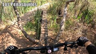
The route offers the most concentrated flow with the least required mileage to be found in the Preserve. You'll enjoy a fun climb up Switchbacks (watch for downhill riders). You'll roll through the surreal Tunnel 4. A series of ups and downs comes next, then it's a downhill run back to the trailhead. Congratulations, you have solved the Flow Equation.

Some things to note:

1. The route is geared to intermediate riders and consists of green and blue trails.

2. The route is short enough to be a lunch ride. Consider The East Ender, which is this route on steroids, if you want a longer flow ride.

3. Please bring a bell. The trails are busy, and sightlines are often limited.

Detailed Description
Flow Equation is a 7 mile popular intermediate route located near San Diego California. This mountain bike only route and has a moderate overall physical rating. This route includes 8 trails. This route climbs 407 ft with a max elevation of 440 ft then descends -403 ft.

Local Trail Association

Local trail association
San Diego Mountain Biking Association (sdmba.com)
Please consider joining or donating to the local riding association to support trail development & maintenance.
Donate to earn trail karma!

Stats

  • Distance
    7 miles
  • Avg time
    1 hr 29 min
  • Altitude change
    4 ft
  • Altitude min
    130 ft
  • Altitude start
    150 ft
  • Altitude end
    154 ft
  • Climb
    407 ft
  • Descent
    -403 ft
  • Grade max
    -11.6%
  • Grade min
    20%
  • Distance climb
    3 miles
  • Distance down
    3 miles
  • Distance flat
    1 mile

33 Reviews & Comments

KeithFieldhammer
Fun fun fun till Daddy takes the Ripmo away!

We hope you've been enjoying Trailforks!

Create a FREE account to view all route reviews and much more.

Trails in Route

Switchbacks Road984 ft
Switchbacks2,887 ft
West Rim2,185 ft
North Rim1,919 ft
Bowtie Rim2,710 ft
Tunnel 45,072 ft
East Deer Canyon1,916 ft
West Deer Canyon5,256 ft

Details

  • Riding area
  • Primary Activity
    Mountain Bike
  • Difficulty rating
    Blue
  • eBike Allowed
  • Bike type
    AM, XC
  • Physical rating
    Moderate
  • Activity Logs
    30
Avg: 3.9 (8 votes)
close
Trail transparency
  • Singletrack
  • Unpaved
mtb
114
mtb
90
mtb
trail: Bowtie Rim
82
mtb
138
Minimal Climbing, Maximum Fun at Los...
mtb
Minimal Climbing, Maximum Fun at Los Peñasquitos Canyon
trail: Tunnel 4
16:05 | 4 | comments: 0 | favs:
Sep 14, 2026

Recent Trail Reports Along Route

statustraildateconditiondescription
Switchbacks Road
Sep 12, 2026 @ 6:32am (America/Tijuana)
Sep 12, 2026
Switchbacks
Sep 12, 2026 @ 6:32am (America/Tijuana)
Sep 12, 2026
West Rim
Sep 12, 2026 @ 6:32am (America/Tijuana)
Sep 12, 2026
Tunnel 4
Aug 6, 2026 @ 3:28pm (America/Los_Angeles)
Aug 6, 2026
Bowtie Rim
Jul 7, 2026 @ 7:03am (America/Tijuana)
Jul 7, 2026
more reports »
  • By Jmlascala71TF Pro SDMBA SDMBA-BP & contributors
  • #26473 - 4,058 views

Hit the Trail

Open in App

Get this route on your phone instantly.

Download Route

Save to wishlist, Garmin & download.

