

Open in App
Get this route on your phone instantly.
“Got there late or want a final quick blast before you go home? Pendam is the definitive “Now That’s What I Call Nant Yr Arian” compilation album with all your favourite toe tapping technical singletrack and wilderness power ballads on one CR (Compact Ride, it’s a new format)”
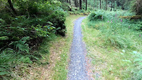
This route combines sections of the ‘Summit’ and ‘Syfydrin’ trails to give you a taste of the fantastic riding and scenery available. Although it is the shortest route at Nant yr Arian, it includes lots of sweet singletrack and some hard climbs, parts of it are technically challenging so take care. Watch out for other users of the trail, it includes sections of public road and tracks shared with horse riders.
We hope you've been enjoying Trailforks!
Create a FREE account to view route comments and much more.
| 4,629 ft | |||||
| 801 ft | |||||
| 1,020 ft | |||||
| 1,368 ft | |||||
| 935 ft | |||||
| 1,952 ft | |||||
| 2,493 ft | |||||
| 3,724 ft | |||||
| 1,916 ft | |||||
| 1 mile | |||||
| 4,777 ft | |||||
| 3,353 ft | |||||
| 2,162 ft | |||||
| 341 ft | |||||
| 991 ft | |||||
| 1,660 ft |

Service Road Atlas is a free to use, community-driven service for viewing and creating reports on the numerous back-country service roads around B.C. and Alberta.
Save the current map location and zoom level as your default home location whenever this page is loaded.
Save