more stats
3,678 ft
Distance
-606 ft
Descent
00:10:37
Avg time
-606 ft
Altitude change
332 ft
Altitude min
938 ft
Altitude max
938 ft
Altitude start
331 ft
Altitude end
-16.5%
Grade
-43.2%
Grade max
1.5%
Grade min
20 ft
Distance climb
3,547 ft
Distance down
112 ft
Distance flat
00:10:37
Avg time

609 Details

  • Activities
    • Mountain Bike
    • E-Bike
  • Riding Area
  • Ref Number
    #20
  • Difficulty Rating
  • Local Popularity
    70 in Mountain Biking [+]
    • 75 in E-Biking
  • Global Ranking
    #51284 in Mountain Biking [+]
    • #33323 in E-Biking
  • Trail Type
    Singletrack
  • Bike Type
    DH, AM
  • Climb Difficulty
    Double Black Diamond
  • Physical Rating
    Moderate
  • Dogs Allowed
    Yes
  • eBike Allowed
    Yes up to Class 1
  • TTFs on Trail
    Rock Garden, Skinny
  • Ride in Rain
    Yes
  • Land Owner

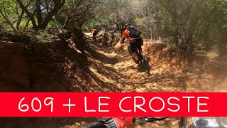
this one is a old line refreshed last season 2017 ,it starts from the highest poit mt.massoncello ,a natural trail addicted to ride mtb ,it s full o technics passages ,at the first you can ride easly and fast but stay on focus ,a steep session in a skinny sequence is coming. at the end you can got a connection with le second part of CROSTE trail.
RIDEANDCHILL

Trail Supporters

Recent Activity on Trail

Past Week
  • 2 rides
  • 23.2 km average
6 Months
  • 41 rides
  • 39.0 km avg distance
All
  • 98 rides
  • Last: Jun 3, 2026
c1c2c3c4
January
February
March
April
May
June
July
August
September
October
November
December
Status:
on Apr 26, 2026
Ideal
Avg: 4.56 (20 votes)
Your vote: 0

view (779)
close
3D
Trail Conditions
  • Unknown
  • Snow Groomed
  • Snow Packed
  • Snow Covered
  • Snow Cover Partial
  • Freeze/thaw Cycle
  • Icy
  • Prevalent Mud
  • Wet
  • Variable
  • Ideal
  • Dry
  • Very Dry
Trail Flow (Ridden Direction)
Trailforks scans users ridelogs to determine the most popular direction each trail is ridden. A good flowing trail network will have most trails flowing in a single direction according to their intension.
The colour categories are based on what percentage of riders are riding a trail in its intended direction.
  • > 96%
  • > 90%
  • > 80%
  • > 70%
  • > 50%
  • < 50%
  • bi-directional trail
  • no data
Trail Last Ridden
Trailforks scans ridelogs to determine the last time a trail was ridden.
  • < 2 days
  • < 1 week
  • < 2 weeks
  • < 1 month
  • < 6 months
  • > 6 months
Trail Ridden Direction
The intended direction a trail should be ridden.
  • Downhill Only
  • Downhill Primary
  • Both Directions
  • Uphill Primary
  • Uphill Only
  • One Direction
Contribute Details
Colors indicate trail is missing specified detail.
  • Description
  • Photos
  • Description & Photos
  • Videos
Trail Popularity ?
Trailforks scans ridelogs to determine which trails are ridden the most in the last 9 months. Trails are compared with nearby trails in the same city region with a possible 25 colour shades. Think of this as a heatmap, more rides = more kinetic energy = warmer colors.
  • most popular
  • popular
  • less popular
  • not popular
ATV/ORV/OHV Filter
Max Vehicle Width
inches
US Cell Coverage
Legend
cell carrier legend

Radar Time
Activity Recordings
Trailforks uses anonymized public activity data. ?
Activity Recordings
Trailforks uses anonymized public activity data. ?
Personal Heatmap
Activity Types
all / none
Options
2
Date range month
Winter Trails
Warning A routing network for winter maps does not exist. Selecting trails using the winter trails layer has been disabled.
Missing Trails
Most Popular
Least Popular
Trails are colored based on popularity. The more popular a trail is, the more red. Less popular trails trend towards green.
Jump Magnitude Heatmap
Heatmap of where riders jump on trails. Zoom in to see individual jumps, click circles to view jump details.
BC Backroad Status

Service Road Atlas is a free to use, community-driven service for viewing and creating reports on the numerous back-country service roads around B.C. and Alberta.

map legend
Slope Aspect
Direction the slope faces
Flat N NE E SE S SW W NW
Trails Deemphasized
Trails are shown in grey.
disable
Only show trails with no bike usage.
Enable
Suggested Layers
Based on selected activity type

    Save the current map location and zoom level as your default home location whenever this page is loaded.

    Save
        Directions to 609 trailhead (42.963330, 10.497860)

        Photos

        No photos have been added for 609 yet, add a photo.

        Videos

        11 more »
        youtuber MTB Piombino 11.05.2024 sentieri 609 + LE CROSTE
        6:49 | 282 | May 12, 2024 , Piombino
        youtuber Piombino - 609 + Sogno | Tuscany 2024
        8:28 | 224 | Apr 28, 2024 , Piombino
        youtuber 609 + Toboga + Fosso alle Canne - Piombino MTB...
        6:37 | 452 | Dec 23, 2022 , Piombino
        609 - Piombino   | LINES
        3:29 | 76 | Nov 20, 2025 , Piombino

        Routes with this trail

        4.0 17 miles 3,535 ft 5
        This is a testing ride out in the bush of Punta Ala Trail Center that takes in steep climbs and descents...
        5.0 18 miles 3,340 ft 9 Loop
        great tour with various tracks/ Parts, technical + great impressions

        3 Reviews & Comments


        We hope you've been enjoying Trailforks!

        Create a FREE account to view trail comments and much more.

        • By piombino-mtb-area & contributors
        • #154618 - 2,545 views

        Frequently Asked Questions About 609

        Where is 609 located?
        609 is located in Piombino MTB Area, Piombino, Italy. It is part of the Piombino MTB Area trail network. The trailhead is located at coordinates 42.96333, 10.49786.
        How hard is 609?
        609 is rated as Black difficulty. The physical rating is Moderate. The average grade is 16.5%. The climb difficulty is rated Double Black Diamond.
        What is the elevation gain for 609?
        The trail has 185 m of elevation descent. The elevation ranges from 101 m to 286 m.
        How long is 609?
        609 is 1.1 km long. The trail type is singletrack.

        Hit the Trail

        Open in App

        Get this trail on your phone instantly.
        open trail in app

        Download Trail

        Save to wishlist, Garmin & download.
        save the trail

        Find Related Routes

        Find routes and users activities that include this trail.
        find routes for this trail

        You must enter a description before submitting.