
more stats
1.1 miles
Distance
31 ft
Climb
-560 ft
Descent
00:07:57
Avg time
-529 ft
Altitude change
945 ft
Altitude min
1,481 ft
Altitude max
1,474 ft
Altitude start
945 ft
Altitude end
-9.2%
Grade
-69.1%
Grade max
32%
Grade min
486 ft
Distance climb
4,675 ft
Distance down
571 ft
Distance flat
00:07:57
Avg time

Anninger-Trail Details

  • Activities
    • Mountain Bike
    • E-Bike
  • Riding Area
  • AKA
    Official
  • Difficulty Rating
  • Local Popularity
    80 in Mountain Biking heatmap [+]
    • 90 in E-Biking
  • Global Ranking
    #83820 in Mountain Biking [+]
    • #86535 in E-Biking
  • National Ranking
    #567 in Mountain Biking · Austria [+]
    • #506 in E-Biking
  • Trail Type
    Singletrack
  • Bike Type
    AM, XC, Fat
  • Direction
    One Direction
    Popular Direction Shown
  • Physical Rating
    Moderate
  • Trail Visibility
    Always easy to follow
  • Season
    Mar - Oct
  • Dogs Allowed
    Yes
  • eBike Allowed
    Yes up to Class 1
  • TTFs on Trail
    Berm, Jump

Einfacher, großteils mäßig steiler und flowiger Natur-Trail. Einige Wurzeln und Steine sind zu erwarten, aber nichts allzu schwieriges, nur am Ende wird der Trail etwas steiler. Der Trail verläuft parallel zur wichtigsten Fortstraße am Anninger, was ihn zum meistbefahrenen macht.
Schöne Schwarzföhren Wälder bringen mediterranes Feeling. Unbedingt beim Aussichtsplatzl oberhalb der Friedrichswand stehen bleiben
________________________

Easy, mostly gentle and flowy nature trail. Expect some roots and rocks, but nothing too difficult; gets a bit steeper in the last section. Most frequented trail as it runs along the main uphill on Anninger.
The dominant pinetrees and a nice viewpoint above Friedrichswand resemble mediterranean Mtb-Areas.

Tags
BermsFlowyJumpsViews

Local Trail Association

Recent Activity on Trail

Past Week
  • 0 rides
  •  
6 Months
  • 67 rides
  • 14 miles avg distance
All
  • 267 rides
  • Last: Nov 6, 2026
c1c2c3c4
January
February
March
April
May
June
July
August
September
October
November
December
update trails status or condition

Anninger-Trail Trail Reports

Status:
on Nov 2, 2026
Avg: 4.4 (14 votes)
Your vote: 0

view (1,405)
close
      Directions to anningertrail trailhead (48.066230, 16.264750)

      Photos

      9 more »
      mtb
      325 |
      Oct 19, 2020 @ 3:41am
      Oct 19, 2020
      mtb
      212 |
      Apr 4, 2020 @ 9:15am
      Apr 4, 2020
      mtb
      206 |
      Apr 4, 2020 @ 9:15am
      Apr 4, 2020
      mtb
      199 |
      Apr 4, 2020 @ 9:15am
      Apr 4, 2020

      Videos

      4 more »
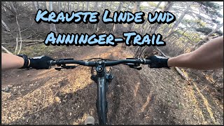
      Krauste Linde und Anninger Trail - MTB Area...
      mtb
      6:26 | 60 | Mar 21, 2026 , Mödling
      youtuber Anninger Trail - Follow Cam ft. Phil B (get...
      mtb
      4:30 | 613 | Dec 9, 2020 , Mödling
      youtuber Anninger Official  Trail  2020 | Anninger |...
      mtb
      4:58 | 612 | Aug 4, 2020 , Mödling
      Kleiner Anninger Trail
      mtb
      3:32 | 62 | Apr 13, 2021 , Mödling
      4.6 ★★★★★
      14 Ratings
      5 ★ 57%
      4 ★ 43%
      3 ★
      2 ★
      1 ★

      2 Reviews & Comments

      crisotop crisotop
      Easy but fun flow line that ends in a lot of variants. Similar to “husarentempel” it would be helpful to have a clear line to ride. Can be very misleading when deciding between tons of trailforks
      ktm-boy-69 ktm-boy-69
      Very easy, but nice and flowy track though a beautiful forest. In the last section there are various lines (blue, red, black) for a few metres. Big fun :-)

      We hope you've been enjoying Trailforks!

      Create a FREE account to view all trail reviews and much more.

      • By DerSuperMario & contributors
      • #186029 - 3,871 views

      Frequently Asked Questions

      ▼ Where is Anninger-Trail located?
      Anninger-Trail is located in MTB-Area Anninger, Mödling, Austria. It is part of the MTB-Area Anninger trail network. The trailhead is located at coordinates 48.06623, 16.26475.
      ▼ How hard is Anninger-Trail?
      Anninger-Trail is rated as Blue difficulty. The physical rating is Moderate. The average grade is 9.2%.
      ▼ What is the elevation gain for Anninger-Trail?
      Anninger-Trail has 31 ft of elevation gain. The trail has 560 ft of elevation descent. The elevation ranges from 945 ft to 1,481 ft.
      ▼ Is Anninger-Trail a point to point trail?
      Yes, Anninger-Trail is a point to point trail. The direction is One Direction. The trail type is singletrack.
      ▼ How long is Anninger-Trail?
      Anninger-Trail is 1.1 miles long. The trail type is singletrack.
      ▼ Are dogs allowed on Anninger-Trail?
      Yes, dogs are allowed on Anninger-Trail. Please keep dogs on a leash where required and clean up after them.
      ▼ When is the best time of year to ride Anninger-Trail?
      Anninger-Trail is best visited during: Mar - Oct.
      ▼ How do I access Anninger-Trail? Where is the closest parking trailhead?
      The closest parking and trailhead locations to Anninger-Trail are: View all parking locations in the area.
      ▼ How long does it take to ride Anninger-Trail?
      Based on recorded activities, it takes an average of 8 minutes to ride Anninger-Trail. The trail is 1.1 miles long. Actual times will vary based on fitness level, conditions, and pace. View recent activity logs for more details.
      ▼ How busy is Anninger-Trail?
      Anninger-Trail is a very popular trail. There have been 1,288 recorded activities on this trail. The trail has received 1,405 check-ins. View recent activity on this trail.

      Hit the Trail

      Open in App

      Get this trail on your phone instantly.

      open trail in app

      Download Trail

      Save to wishlist, Garmin & download.
      save the trail

      Find Related Routes

      Find routes and users activities that include this trail.
      find routes for this trail

      You must enter a description before submitting.