

more stats
2,667 ft
Distance
-184 ft
Descent
00:01:18
Avg time
-184 ft
Altitude change
1,141 ft
Altitude min
1,325 ft
Altitude max
1,325 ft
Altitude start
1,142 ft
Altitude end
-6.9%
Grade
-22%
Grade max
-2.5%
Grade min
2,667 ft
Distance down
00:01:18
Avg time

ATM Original Details

  • Activities
    • Mountain Bike
    • E-Bike
    • Winter Fat Bike
    • Hike
    • Trail Running
  • Riding Area
    Santa Fe
    Zaragoza
  • AKA
    A TODA MÁQUINA
  • Difficulty Rating
  • Local Popularity
    100 in Mountain Biking heatmap [+]
    • 100 in E-Biking
    • 5 in Trail Running
    • 5 in Hiking
    • 5 in Winter Fat Biking
  • Global Ranking
    #74508 in Mountain Biking [+]
    • #76604 in E-Biking
    • #355952 in Trail Running
    • #331395 in Hiking
    • #32711 in Winter Fat Biking
  • National Ranking
    #5,108 in Mountain Biking · Spain [+]
    • #12,893 in E-Biking
    • #37,732 in Trail Running
    • #33,334 in Hiking
    • #467 in Winter Fat Biking
  • Trail Type
    Singletrack
  • Bike Type
    DH, AM, XC, Fat
  • Direction
    Downhill Primary[+]
    Popular Direction Shown
    • Downhill Primary for Winter Fat Biking
  • Climb Difficulty
    Blue
  • Trail Visibility
    Always easy to follow
  • Dogs Allowed
    Yes
  • eBike Allowed

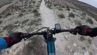
Bajada sin ningún problema de dificultad. La dificultad varía según la velocidad a la que vayas. Mucha gente también lo hace de subida.

Está bastante rota, sobre todo el final, pero despacito se puede hacer sin ningún problema si no tienes nivel (y rápido te lo pasas muy bien).
Las nuevas variantes no están nada rotas, son mucho más rápidas pero más cortas, y acaban en un pequeño rampón que hace que dejen de ser verdes

Tags

Recent Activity on Trail

Past Week
  • 1 rides
  • 21 miles average
6 Months
  • 22 rides
  • 25 miles avg distance
All
  • 254 rides
  • Last: Nov 15, 2026
c1c2c3c4
January
February
March
April
May
June
July
August
September
October
November
December
Status:
on Sep 29, 2026
Ideal
Avg: 3.89 (5 votes)
Your vote: 0

view (1,337)
close
      Directions to atm-original trailhead (41.571270, -0.900880)

      Photos

      2 more »
      ebike
      33 |
      May 17, 2026 @ 4:52am
      May 17, 2026
      ebike
      20 |
      May 17, 2026 @ 4:52am
      May 17, 2026

      Videos

      2 more »
      zgz ebike bajada ATM 20250125
      mtb
      2:56 | 66 | Feb 5, 2025 , Zaragoza
      Senda ATM
      ebike
      5:51 | 10 | Jul 31, 2025 , Zaragoza
      3.8 ★★★★★
      5 Ratings
      5 ★ 40%
      4 ★ 40%
      3 ★
      2 ★
      1 ★ 20%

      2 Reviews & Comments

      ewallpro
      Bajada con la que empezar a darle cuando estás empezando. Tiene un pequeño salto en la parte final esquivable por la izquierda. El resto, flow y escalones de menos de 20 cm.
      pcorreas pcorreas
      Bajada divertida y rápida. Para todos los niveles. El que tenga poco nivel puede hacerla despacio pero el que sea pro y quiera correr no se va a aburrir. Con cuidado porque también se hace de subida

      We hope you've been enjoying Trailforks!

      Create a FREE account to view all trail reviews and much more.

      • By pcorreasTF Pro TFSPAIN & contributors
      • #320899 - 937 views

      Frequently Asked Questions

      ▼ Where is ATM Original located?
      ATM Original is located in Santa Fe, Zaragoza, Spain. It is part of the Santa Fe trail network. The trailhead is located at coordinates 41.57127, -0.90088.
      ▼ How hard is ATM Original?
      ATM Original is rated as Green difficulty. The average grade is 6.9%. The climb difficulty is rated Blue.
      ▼ What is the elevation gain for ATM Original?
      The trail has 184 ft of elevation descent. The elevation ranges from 1,141 ft to 1,325 ft.
      ▼ Is ATM Original a point to point trail?
      ATM Original is not a point to point trail. The direction is Downhill Primary. The trail type is singletrack.
      ▼ How long is ATM Original?
      ATM Original is 2,667 ft long. The trail type is singletrack.
      ▼ Are dogs allowed on ATM Original?
      Yes, dogs are allowed on ATM Original. Please keep dogs on a leash where required and clean up after them.
      ▼ When is the best time of year to ride ATM Original?
      Based on activity log data, the most popular months to ride ATM Original are:
      • May (22 activities)
      • January (16 activities)
      • November (16 activities)
      Check the reports page for current trail conditions.
      ▼ How do I access ATM Original? Where is the closest parking trailhead?
      The closest parking and trailhead locations to ATM Original are: View all parking locations in the area.
      ▼ How long does it take to ride ATM Original?
      Based on recorded activities, it takes an average of 1 minute to ride ATM Original. The trail is 2,667 ft long. Actual times will vary based on fitness level, conditions, and pace. View recent activity logs for more details.
      ▼ How busy is ATM Original?
      ATM Original is a very popular trail. There have been 1,348 recorded activities on this trail. The trail has received 1,337 check-ins. View recent activity on this trail.

      Hit the Trail

      Open in App

      Get this trail on your phone instantly.

      open trail in app

      Download Trail

      Save to wishlist, Garmin & download.
      save the trail

      Find Related Routes

      Find routes and users activities that include this trail.
      find routes for this trail

      You must enter a description before submitting.

