

more stats
1.0 mile
Distance
213 ft
Climb
-230 ft
Descent
00:11:02
Avg time
-17 ft
Altitude change
3,813 ft
Altitude min
3,928 ft
Altitude max
3,832 ft
Altitude start
3,816 ft
Altitude end
-0.3%
Grade
-36.3%
Grade max
36%
Grade min
2,434 ft
Distance climb
1,791 ft
Distance down
1,135 ft
Distance flat
00:11:02
Avg time

Blue Elephant Details

  • Activities
    • Mountain Bike
    • E-Bike
    • Winter Fat Bike
    • Hike
    • Trail Running
  • Riding Area
    Red Mountain Community Trails
    Rossland, British Columbia
  • Difficulty Rating
  • Voted Difficulty
    Blue (1 vote)
  • Local Popularity
    100 in Mountain Biking heatmap [+]
    • 100 in E-Biking
    • 100 in Trail Running
    • 85 in Hiking
    • 100 in Winter Fat Biking
  • Global Ranking
    #33515 in Mountain Biking [+]
    • #5877 in E-Biking
    • #69816 in Trail Running
    • #119276 in Hiking
    • #168 in Winter Fat Biking
  • Provincial Ranking
    #1,648 in Mountain Biking · British Columbia [+]
    • #491 in E-Biking
    • #4,008 in Trail Running
    • #6,467 in Hiking
    • #13 in Winter Fat Biking
  • Hiking SAC Scale
    T1 Hiking
  • Trail Exposure
    Life Threatening
  • Trail Type
    Singletrack
  • Bike Type
    AM, XC, Fat, CX
  • Direction
    Both Directions[+]
    Popular Direction Shown
    • Both Directions for E-Biking
    • Both Directions for Trail Running
    • Both Directions for Hiking
    • Both Directions for Winter Fat Biking
  • Climb Difficulty
    Green
  • Physical Rating
    Easy
  • Trail Visibility
    Always easy to follow
  • Family Friendly
    Yes
  • Dogs Allowed
    Yes
  • eBike Allowed
    Yes up to Class 1
  • TTFs on Trail
    Berm, Rock Face
  • Lighting
    No
  • Year Opened
    2018

A great two-way beginner to intermediate single track trail connecting from Larry's across to the bottom of Redtop. One of the few "flat" or lower angle trails on the Rossland trail menu. This is the perfect trail for bikers to work on their switchback and technical single track skills in order to progress and push abilities to take on higher level blue trails in the network. This trail is also very popular among trail runners and hikers as it offers a welcome alternative to Red Mountain Road when travelling to and from the ski hill.

This is a busy trail with many different types of users. Please use the trail respectfully and follow trail etiquette to ensure a safe user and trail experience for all

Tags
BermsFamily friendlyRock slabs

Recent Activity on Trail

Past Week
  • 1 rides
  • 10.5 km average
6 Months
  • 299 rides
  • 15.2 km avg distance
All
  • 1,542 rides
  • Last: Nov 15, 2026
c1c2c3c4
January
February
March
April
May
June
July
August
September
October
November
December
update trails status or condition

Blue Elephant Trail Reports

statusdatedescription
Aug 30, 2026 @ 9:36am (America/Creston)
Aug 30, 2026
All clear and in great shape.
Aug 23, 2026 @ 12:12pm (America/Creston)
Aug 23, 2026
Scattered wet spots but running well.
Jul 13, 2026 @ 10:50am (America/Vancouver)
Jul 13, 2026
Jun 16, 2026 @ 4:39pm (America/Vancouver)
Jun 16, 2026
reporter Cleared.
Jun 16, 2026 @ 8:42am (America/Vancouver)
Jun 16, 2026
Three trees down across the trail between the Glades housing development and the entrance to Redtop.
more »
Status:
on Aug 30, 2026
Ideal
Avg: 4.31 (11 votes)
Your vote: 0

view (10,413)
close
      Directions to blue-elephant trailhead (49.099860, -117.815530)

      Photos

      6 more »
      mtb
      163 |
      Aug 27, 2020 @ 4:54pm
      Aug 27, 2020
      mtb
      157 |
      Aug 27, 2020 @ 4:53pm
      Aug 27, 2020
      report
      mtb
      89 |
      Dec 4, 2024 @ 2:57pm
      Dec 4, 2024
      report
      mtb
      164 |
      Sep 8, 2020 @ 7:05am
      Sep 8, 2020

      Videos

      2 more »
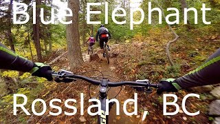
      youtuber Blue Elephant - Rossland, BC
      mtb
      10:48 | 1738 | Oct 7, 2018 , Rossland
      youtuber Blue Elephant, Rossland B.C. - Fat Biking
      mtb
      3:19 | 637 | Jan 15, 2019 , Rossland

      Routes with this trail

      more »
      30 miles • 7,509 ft • 19 • Loop •
      Misogi ride with 7 local summits around Rossland. Only the ultimate athlete will be able to succeed
      9 miles • 1,853 ft • 7 • Loop •
      moderate loop from red to town
      5 miles • 1,114 ft • 6 •
      From the Resort this is a quick loop
      4.6 ★★★★★
      11 Ratings
      5 ★ 64%
      4 ★ 27%
      3 ★ 9%
      2 ★
      1 ★

      3 Reviews & Comments

      Pjochter Pjochter
      This is a great beginner xc trail that can be ridden both ways. Great way to get to miners from the main skihill parking lot area.
      KarinB
      Great beginner's trail with a few technicals. Fun both ways. Link this with Larry's and Moe's and you have a really great loop to ride over and over again.
      bendtrails bendtrails
      This is a really nicely built trail great for beginners and families. We saw a family on the trail as we rode out today and they were all having a blast.

      We hope you've been enjoying Trailforks!

      Create a FREE account to view all trail reviews and much more.

      • By barry-mclaneTF Pro & contributors
      • #146907 - 8,366 views

      Frequently Asked Questions

      ▼ Where is Blue Elephant located?
      Blue Elephant is located in Red Mountain Community Trails, Rossland, British Columbia, Canada. It is part of the Red Mountain Community Trails trail network. The trailhead is located at coordinates 49.09986, -117.81553.
      ▼ How hard is Blue Elephant?
      Blue Elephant is rated as Blue difficulty. The physical rating is Easy. The average grade is 0.3%. The climb difficulty is rated Green.
      ▼ What is the elevation gain for Blue Elephant?
      Blue Elephant has 213 ft of elevation gain. The trail has 230 ft of elevation descent. The elevation ranges from 3,813 ft to 3,928 ft.
      ▼ Is Blue Elephant a point to point trail?
      Blue Elephant is not a point to point trail. The direction is Both Directions. The trail type is singletrack.
      ▼ How long is Blue Elephant?
      Blue Elephant is 1.0 mile long. The trail type is singletrack.
      ▼ Are dogs allowed on Blue Elephant?
      Yes, dogs are allowed on Blue Elephant. Please keep dogs on a leash where required and clean up after them.
      ▼ When is the best time of year to ride Blue Elephant?
      Based on activity log data, the most popular months to ride Blue Elephant are:
      • July (171 activities)
      • June (145 activities)
      • September (144 activities)
      Check the reports page for current trail conditions.
      ▼ How do I access Blue Elephant? Where is the closest parking trailhead?
      The closest parking and trailhead locations to Blue Elephant are: View all parking locations in the area.
      ▼ How long does it take to ride Blue Elephant?
      Based on recorded activities, it takes an average of 11 minutes to ride Blue Elephant. The trail is 1.0 mile long. Actual times will vary based on fitness level, conditions, and pace. View recent activity logs for more details.
      ▼ How busy is Blue Elephant?
      Blue Elephant is a very popular trail. There have been 9,293 recorded activities on this trail. The trail has received 10,410 check-ins. View recent activity on this trail.

      Hit the Trail

      Open in App

      Get this trail on your phone instantly.

      open trail in app

      Download Trail

      Save to wishlist, Garmin & download.
      save the trail

      Find Related Routes

      Find routes and users activities that include this trail.
      find routes for this trail

      You must enter a description before submitting.

