2,336 ft
Distance
-310 ft
Descent
00:02:49
Avg time
Burmese Python Details
-
Activities
- Mountain Bike
-
Riding AreaBeech Mountain Bike Park
Beech Mountain, North Carolina -
Difficulty Rating
-
Trail TypeSingletrack
-
Bike TypeDH
-
DirectionDownhill OnlyPopular direction shown
-
Physical RatingHard
-
SeasonWhen Open
-
eBike Allowed
-
TTFs on TrailDrop, Jump
-
Global Ranking#7859 in Mountain Biking
-
Local Popularity75 in Mountain Biking
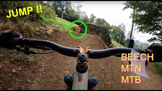
Flow trail with features. Make sure to nose bonk the rock after the last left hander
Traditionally Indigenous Territory
More Stats for Burmese Python mountain bike trail trail
-
Altitude change-310 ft
-
Altitude min4,982 ft
-
Altitude max5,292 ft
-
Altitude start5,292 ft
-
Altitude end4,984 ft
-
Grade-13.3%
-
Grade max-38.9%
-
Grade min-3.8%
-
Distance down2,336 ft
-
Avg time00:02:49
- view trail stats
close
3D
Trail Conditions
- Unknown
- Snow Groomed
- Snow Packed
- Snow Covered
- Snow Cover Partial
- Freeze/thaw Cycle
- Icy
- Prevalent Mud
- Wet
- Variable
- Ideal
- Dry
- Very Dry
Trail Flow (Ridden Direction)
Trailforks scans users ridelogs to determine the most popular direction each trail is ridden. A good flowing trail network will have most trails flowing in a single direction according to their intension.
The colour categories are based on what percentage of riders are riding a trail in its intended direction.
- > 96%
- > 90%
- > 80%
- > 70%
- > 50%
- < 50%
- bi-directional trail
- no data
Trail Last Ridden
Trailforks scans ridelogs to determine the last time a trail was ridden.
- < 2 days
- < 1 week
- < 2 weeks
- < 1 month
- < 6 months
- > 6 months
Trail Ridden Direction
The intended direction a trail should be ridden.
- Downhill Only
- Downhill Primary
- Both Directions
- Uphill Primary
- Uphill Only
- One Direction
Contribute Details
Colors indicate trail is missing specified detail.
- Description
- Photos
- Description & Photos
- Videos
Trail Popularity ?
Trailforks scans ridelogs to determine which trails are ridden the most in the last 9 months.
Trails are compared with nearby trails in the same city region with a possible 25 colour shades.
Think of this as a heatmap, more rides = more kinetic energy = warmer colors.
- most popular
- popular
- less popular
- not popular
ATV/ORV/OHV Filter
Max Vehicle Width
inches
US Cell Coverage
Legend
Radar Time
x
Activity Recordings
Trailforks users anonymized public ridelogs from the past 6 months.
- mountain biking recent
- mountain biking (>6 month)
- hiking (1 year)
- moto (1 year)
Activity Recordings
Trailforks users anonymized public skilogs from the past 12 months.
- Downhill Ski
- Backcountry Ski
- Nordic Ski
- Snowmobile
Winter Trails
Warning
A routing network for winter maps does not exist. Selecting trails using the winter trails layer has been disabled.
x
Missing Trails
Most Popular
Least Popular
Trails are colored based on popularity. The more popular a trail is, the more red. Less popular trails trend towards green.
Jump Magnitude Heatmap
Heatmap of where riders jump on trails. Zoom in to see individual jumps, click circles to view jump details.
Trails Deemphasized
Trails are shown in grey.
Only show trails with NO bikes.
Save the current map location and zoom level as your default home location whenever this page is loaded.
Save
Directions to burmese-python trailhead
(36.187040, -81.879200)
update trails status or condition
Burmese Python Trail Reports
view all reports »
Recent Ridelog Activity on Trail
Past Week
- 0 rides
6 Months
- 0 rides
All
- 103 rides
- Last: Aug 17, 2024
Photos
no photos have been added for Burmese Python yet, add a photo.
Reviews / Comments
No reviews yet, be the first to write a review or ask a question.
Use trail reports to comment on trail conditions.
We hope you've been enjoying Trailforks!
Create a FREE account to view trail comments and much more.
Videos
more »
Nearby Trails
- Copperhead 0 ft
- Black Mamba 535 ft
- Black Bear Upper 830 ft
- Black Bear Lower 869 ft
- Indigo 1,102 ft
Beech Mountain Bike Park
- By caleb93
& contributors
- #5910 - 2,813 views
- follow/subscribe
- login to download gpx or kml files.
You must enter a description before submitting.