

more stats
2,608 ft
Distance
-588 ft
Descent
00:08:50
Avg time
-588 ft
Altitude change
1,735 ft
Altitude min
2,323 ft
Altitude max
2,323 ft
Altitude start
1,736 ft
Altitude end
-22.5%
Grade
-57.3%
Grade max
-1%
Grade min
2,608 ft
Distance down
00:08:50
Avg time

Ciklama Details

  • Activities
    • Mountain Bike
    • Winter Fat Bike
  • Riding Area
    Gorjanci
    Novo mesto
  • Difficulty Rating
  • Voted Difficulty
    Red (1 vote)
  • Local Popularity
    60 in Mountain Biking [+]
    • 5 in Winter Fat Biking
  • Global Ranking
    #81046 in Mountain Biking
  • Trail Type
    Singletrack
  • Bike Type
    AM, Fat
  • Direction
    Downhill Only
    Popular Direction Shown
  • Physical Rating
    Moderate
  • Trail Visibility
    Sometimes hard to follow
  • Season
    April - October
  • eBike Allowed
    Yes up to Class 1
  • TTFs on Trail
    Berm, Drop, Jump, Other
  • Year Opened
    2019

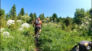
First part of Ciklama is flowy trail, with berms and some easy jumps. In wet conditions could be sleppery in corners. Middle part of trail is more techical with stepdowns and some close cornes. Drop at the end of the trail is not so hard, but recomended check landing first. There is "chicken way" on the left side of the drop. Send it and enyoy.

Access Info

Easy to find, just follow the hiking path to the mark when trail start.

Trail Supporters
  • Društvo Zverinice
    Builder

Recent Activity on Trail

Past Week
  • 0 rides
  •  
6 Months
  • 5 rides
  • 32 miles avg distance
All
  • 50 rides
  • Last: Sep 4, 2026
c1c2c3c4
January
February
March
April
May
June
July
August
September
October
November
December
update trails status or condition

Ciklama Trail Reports

statusdatedescription
Aug 18, 2024 @ 10:08am
Aug 18, 2024
All good, running great!
Aug 15, 2022 @ 10:33am
Aug 15, 2022
Jun 4, 2022 @ 12:14pm
Jun 4, 2022
Prvi del traila zapuščen-veliko listja, suhe veje na trailu (tudi namenoma položene)!? Razen, če sem zgrešil linijo, a po gps sledi sodeč,...
Apr 17, 2022 @ 2:13am
Apr 17, 2022
Excellent
Mar 16, 2022 @ 8:27am
Mar 16, 2022
Brappp brapppp
more »
Status:
on Aug 18, 2024
Dry
Avg: 3.99 (3 votes)
Your vote: 0

view (283)
close
      Directions to ciklama trailhead (45.774210, 15.293170)

      Photos

      20 more »
      mtb
      179 |
      Jun 10, 2025 @ 3:21pm
      Jun 10, 2025
      mtb
      126 |
      Jun 10, 2025 @ 3:20pm
      Jun 10, 2025
      mtb
      152 |
      Jun 10, 2025 @ 3:06pm
      Jun 10, 2025
      mtb
      147 |
      Jun 10, 2025 @ 3:06pm
      Jun 10, 2025

      Videos

      2 more »
      Sveta Gera/Trdinov vrh: Trdinka + Ciklama +...
      mtb
      13:37 | 952 | Jul 12, 2021 , Novo mesto
      MTB gorjanci trdinka, ciklama trail
      mtb
      7:00 | 512 | Jun 20, 2021 , Novo mesto
      4.0 ★★★★★
      3 Ratings
      5 ★ 67%
      4 ★
      3 ★
      2 ★ 33%
      1 ★

      2 Reviews & Comments

      Marczver Marczver
      Lastnik gozda, kjer poteka trail, nas je obvestil, da bo sekal smreke v naslednjih dneh, zato bo začetek traila neprevozen. Obvoz je po vlaki do prvega ovinka, kjer zavijete desno nazaj na trail.

      We hope you've been enjoying Trailforks!

      Create a FREE account to view all trail reviews and much more.

      • By Marczver & contributors
      • #220746 - 2,049 views

      Frequently Asked Questions

      ▼ Where is Ciklama located?
      Ciklama is located in Gorjanci, Novo mesto, Slovenia. It is part of the Gorjanci trail network. The trailhead is located at coordinates 45.77421, 15.29317.
      ▼ How hard is Ciklama?
      Ciklama is rated as Red difficulty. The physical rating is Moderate. The average grade is 22.5%.
      ▼ What is the elevation gain for Ciklama?
      The trail has 588 ft of elevation descent. The elevation ranges from 1,735 ft to 2,323 ft.
      ▼ Is Ciklama a point to point trail?
      Yes, Ciklama is a point to point trail. The direction is Downhill Only. The trail type is singletrack.
      ▼ How long is Ciklama?
      Ciklama is 2,608 ft long. The trail type is singletrack.
      ▼ Are dogs allowed on Ciklama?
      There is no information about dogs being allowed on Ciklama. Check with local trail managers or the trail page for the latest access rules.
      ▼ When is the best time of year to ride Ciklama?
      Based on activity log data, the most popular months to ride Ciklama are:
      • June (10 activities)
      • November (8 activities)
      • December (3 activities)
      Check the reports page for current trail conditions.
      ▼ How do I access Ciklama? Where is the closest parking trailhead?
      The closest parking and trailhead locations to Ciklama are: View all parking locations in the area.
      ▼ How long does it take to ride Ciklama?
      Based on recorded activities, it takes an average of 5 minutes to ride Ciklama. The trail is 2,608 ft long. Actual times will vary based on fitness level, conditions, and pace. View recent activity logs for more details.
      ▼ How busy is Ciklama?
      Ciklama is a moderately popular trail. There have been 257 recorded activities on this trail. The trail has received 283 check-ins. View recent activity on this trail.

      Hit the Trail

      Open in App

      Get this trail on your phone instantly.

      open trail in app

      Download Trail

      Save to wishlist, Garmin & download.
      save the trail

      Find Related Routes

      Find routes and users activities that include this trail.
      find routes for this trail

      You must enter a description before submitting.



