
more stats
3.0 miles
Distance
518 ft
Climb
-1,222 ft
Descent
2,257 ft
High Point
-705 ft
Altitude change
1,552 ft
Altitude min
2,257 ft
Altitude start
1,552 ft
Altitude end
-4.483%
Grade
-42.187%
Grade max
42.601%
Grade min
1 mile
Distance climb
2 miles
Distance down
703 ft
Distance flat

Cornua - Redentore Details

  • Activities
    • Mountain Bike
    • Winter Fat Bike
    • Hike
    • Trail Running
  • Riding Area
  • Difficulty Rating
  • Voted Difficulty
    Blue (1 vote)
  • Local Popularity
    20 in Mountain Biking heatmap [+]
    • 5 in Trail Running
    • 5 in Hiking
    • 5 in Winter Fat Biking
  • Global Ranking
    #144077 in Mountain Biking [+]
    • #355070 in Trail Running
    • #305226 in Hiking
    • #5764 in Winter Fat Biking
  • National Ranking
    #10,935 in Mountain Biking · Italy [+]
    • #13,577 in Trail Running
    • #11,164 in Hiking
    • #266 in Winter Fat Biking
  • Hiking SAC Scale
    T1 Hiking
  • Trail Type
    Singletrack
  • Bike Type
    AM, XC, Fat
  • Direction
    Downhill Primary
    Popular Direction Shown
  • Climb Difficulty
    Blue
  • Physical Rating
    Moderate
  • Dogs Allowed
    Yes

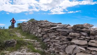
Nice trail with great view. Up & down with tech passage , some short sections by foot.
The walking trail have symbol "II red" you can follow always it but in two point it's better to go on the ridge as reported here

Access Info

From Sori or Recco by asphalt road , Sori as start point is much better

Tags
RidgelineViews

Recent Activity on Trail

Past Week
  • 0 rides
  •  
6 Months
  • 0 rides
  •  
All
  • 1 rides
  •  
update trails status or condition

Cornua - Redentore Trail Reports

statusdatedescription
Nov 14, 2026 @ 9:04am (Europe/Monaco)
Nov 14, 2026
Jul 16, 2026 @ 7:01am (Europe/Rome)
Jul 15, 2026
Dec 12, 2025 @ 1:51am (America/Vancouver)
Dec 12, 2025
perfettamente pulito e fattibile sia in salita che in discesa
Nov 3, 2025 @ 6:29pm (Europe/Rome)
Nov 3, 2025
La primissima parte spettacolare. Poi personalmente non è un sentiero da bici. Mille rilanci e tutti da fare a spinta. Sconsigliato
Oct 28, 2025 @ 4:34pm (Europe/Rome)
Oct 28, 2025
superlativo e grazie ha chi ha messo sapientemente delle pietre per agevolare alcuni passaggi ostici
more »
Status:
on Nov 14, 2026
Variable
Avg: 3.74 (3 votes)
Your vote: 0

view (3)
close
      Directions to cornua-redentore trailhead (44.407330, 9.133850)

      Photos

      7 more »
      mtb
      156 |
      Nov 27, 2022 @ 1:03pm
      Nov 27, 2022
      mtb
      148 |
      Nov 27, 2022 @ 8:48am
      Nov 27, 2022
      mtb
      214 |
      Dec 1, 2021 @ 9:07am
      Dec 1, 2021
      mtb
      209 |
      Dec 1, 2021 @ 9:07am
      Dec 1, 2021

      Videos

      1 more »
      Cornua - S.Apollinare
      mtb
      18:20 | 245 | May 19, 2025 , Genova
      2.4 ★★★★★
      3 Ratings
      5 ★ 33%
      4 ★
      3 ★
      2 ★
      1 ★ 67%

      4 Reviews & Comments

      RahelyJOtIH
      Useless trail, thorns all over. Don't do it.
      tado79 tado79
      Fatto ieri. Bel Trail panoramico e impegnativo, non molla un'attimo...
      barolo71 barolo71
      Il trail è molto bello anche in senso inverso, è un pedalato tecnico molto divertente, basta evitare la cresta seguendo la traccia che taglia sotto il Castellettola e il Cassinea.
      Per chi sale da Verzemma l'ideale è seguire il trail Munta e China e Atrovime, ripidi ma al 80% pedalabili da gamba ben allenata

      We hope you've been enjoying Trailforks!

      Create a FREE account to view all trail reviews and much more.

      • By barolo71TF Pro & contributors
      • #156746 - 1,811 views

      Frequently Asked Questions

      ▼ Where is Cornua - Redentore located?
      Cornua - Redentore is located in Monte Fasce Bike Trails Area, Genova, Italy. It is part of the Monte Fasce Bike Trails Area trail network. The trailhead is located at coordinates 44.40733, 9.13385.
      ▼ How hard is Cornua - Redentore?
      Cornua - Redentore is rated as Red difficulty. The physical rating is Moderate. The average grade is 4.483%. The climb difficulty is rated Blue.
      ▼ What is the elevation gain for Cornua - Redentore?
      Cornua - Redentore has 518 ft of elevation gain. The trail has 1,222 ft of elevation descent. The elevation ranges from 1,552 ft to 2,257 ft.
      ▼ Is Cornua - Redentore a point to point trail?
      Cornua - Redentore is not a point to point trail. The direction is Downhill Primary. The trail type is singletrack.
      ▼ How long is Cornua - Redentore?
      Cornua - Redentore is 3.0 miles long. The trail type is singletrack.
      ▼ Are dogs allowed on Cornua - Redentore?
      Yes, dogs are allowed on Cornua - Redentore. Please keep dogs on a leash where required and clean up after them.
      ▼ How do I access Cornua - Redentore? Where is the closest parking trailhead?
      The closest parking and trailhead locations to Cornua - Redentore are: View all parking locations in the area.
      ▼ How busy is Cornua - Redentore?
      Cornua - Redentore is a less popular trail with lighter traffic. There have been 2 recorded activities on this trail. The trail has received 3 check-ins. View recent activity on this trail.

      Hit the Trail

      Open in App

      Get this trail on your phone instantly.

      open trail in app

      Download Trail

      Save to wishlist, Garmin & download.
      save the trail

      Find Related Routes

      Find routes and users activities that include this trail.
      find routes for this trail

      You must enter a description before submitting.

