more stats
1.8 miles
Distance
405 ft
Climb
-50 ft
Descent
1 mile
High Point
352 ft
Altitude change
5,682 ft
Altitude min
5,683 ft
Altitude start
6,037 ft
Altitude end
3.7%
Grade
-21.9%
Grade max
18.2%
Grade min
2 miles
Distance climb
873 ft
Distance down
696 ft
Distance flat

Devil's Kitchen Details

  • Activities
    • Hike
    • Trail Running
  • Riding Area
    Lassen Volcanic National Park
    Redding, California
  • Difficulty Rating
  • Local Popularity
    60 in Hiking [+]
    • 50 in Trail Running
  • Global Ranking
    #62018 in Hiking [+]
    • #305966 in Trail Running
  • Hiking SAC Scale
    T2 Mountain Hiking
  • Trail Type
    Singletrack
  • Direction
    Both Directions
  • Physical Rating
    Moderate
  • Trail Visibility
    Always easy to follow
  • Family Friendly
    Yes

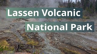
Experience Lassen's second largest hydrothermal via a lovely hike through Warner Valley meadows and forest. Along with a number of other hikes, the trail begins at the Warner Valley trailhead. The first 0.4 mile passes through a meadow over small footbridges and boardwalks before crossing Hot Springs Creek. At the first intersection, go right to continue to Devils Kitchen. Again, a series of footbridges and boardwalks help hikers navigate through marsh and woodlands to the intersection for Dream Lake Basin at 0.6 mile. Go right again and continue towards the meadow. Here the trail then follows Hot Springs Creek before climbing through forest and on into woodland. At the third intersection, turn right for the last 0.9 mile to Devils Kitchen. A series of rises and dips takes the trail through two seasonal stream crossings before the trail rises a last time to the rim of Devils Kitchen. Continue the last 0.2 mile downhill to a bridge the crosses milky Hot Springs Creek. Here a loop trail leads hikers through the sense-reviving boiling mudpots, steam vents and boiling springs. Wander among the crackled yellow and red mounds of the kitchen where steam whirls from fiery cracks in the ground, sounds of plopping, hissing and belching fill your ears and the smell of "something" cooking lingers in the air.

Traditionally Indigenous Territory

Recent Activity on Trail

Past Week
  • 0 rides
  •  
6 Months
  • 0 rides
  •  
All
  • 3 rides
  •  
update trails status or condition

Devil's Kitchen Trail Reports

statusdatedescription
Sep 11, 2025 @ 10:10pm (America/Los_Angeles)
Sep 11, 2025
Despite the bridge out signs, there is easy to cross log replacing the bridge. They are starting construction on a new bridge along with repairs...
more »
Status:
on Sep 11, 2025
Ideal
Avg: 3.84 (1 votes)
Your vote: 0

view (7)
close
3D
Trail Conditions
  • Unknown
  • Snow Groomed
  • Snow Packed
  • Snow Covered
  • Snow Cover Partial
  • Freeze/thaw Cycle
  • Icy
  • Prevalent Mud
  • Wet
  • Variable
  • Ideal
  • Dry
  • Very Dry
Trail Flow (Ridden Direction)
Trailforks scans users ridelogs to determine the most popular direction each trail is ridden. A good flowing trail network will have most trails flowing in a single direction according to their intension.
The colour categories are based on what percentage of riders are riding a trail in its intended direction.
  • > 96%
  • > 90%
  • > 80%
  • > 70%
  • > 50%
  • < 50%
  • bi-directional trail
  • no data
Trail Last Ridden
Trailforks scans ridelogs to determine the last time a trail was ridden.
  • < 2 days
  • < 1 week
  • < 2 weeks
  • < 1 month
  • < 6 months
  • > 6 months
Trail Ridden Direction
The intended direction a trail should be ridden.
  • Downhill Only
  • Downhill Primary
  • Both Directions
  • Uphill Primary
  • Uphill Only
  • One Direction
Contribute Details
Colors indicate trail is missing specified detail.
  • Description
  • Photos
  • Description & Photos
  • Videos
Trail Popularity ?
Trailforks scans ridelogs to determine which trails are ridden the most in the last 9 months. Trails are compared with nearby trails in the same city region with a possible 25 colour shades. Think of this as a heatmap, more rides = more kinetic energy = warmer colors.
  • most popular
  • popular
  • less popular
  • not popular
ATV/ORV/OHV Filter
Max Vehicle Width
inches
US Cell Coverage
Legend
cell carrier legend

Radar Time
Activity Recordings
Trailforks uses anonymized public activity data. ?
Activity Recordings
Trailforks uses anonymized public activity data. ?
Personal Heatmap
Activity Types
all / none
Options
2
Date range month
Winter Trails
Warning A routing network for winter maps does not exist. Selecting trails using the winter trails layer has been disabled.
Missing Trails
Most Popular
Least Popular
Trails are colored based on popularity. The more popular a trail is, the more red. Less popular trails trend towards green.
Jump Magnitude Heatmap
Heatmap of where riders jump on trails. Zoom in to see individual jumps, click circles to view jump details.
BC Backroad Status

Service Road Atlas is a free to use, community-driven service for viewing and creating reports on the numerous back-country service roads around B.C. and Alberta.

map legend
Slope Aspect
Direction the slope faces
Flat N NE E SE S SW W NW
Trails Deemphasized
Trails are shown in grey.
disable
Only show trails with no bike usage.
Enable
Suggested Layers
Based on selected activity type

    Save the current map location and zoom level as your default home location whenever this page is loaded.

    Save
        Directions to devil-s-kitchen trailhead (40.443920, -121.404720)

        Photos

        8 more »
        86 |
        Dec 31, 2019 @ 10:06am
        Dec 31, 2019
        40 |
        Nov 16, 2025 @ 4:39pm
        Nov 16, 2025
        49 |
        Nov 16, 2025 @ 4:39pm
        Nov 16, 2025
        41 |
        Nov 16, 2025 @ 4:39pm
        Nov 16, 2025

        Videos

        1 more »
        Lassen Volcanic NP Warner Valley Thermal Features
        0:55 | 26 | Nov 16, 2025 , Redding

        Routes with this trail

        4 miles 480 ft 1

        Reviews / Comments

        No reviews yet, be the first to write a review or ask a question.
        Use trail reports to comment on trail conditions.


        We hope you've been enjoying Trailforks!

        Create a FREE account to view trail comments and much more.

        • By toddTF Pro Trailforks & contributors
        • #243570 - 1,124 views

        Frequently Asked Questions About Devil's Kitchen

        Where is Devil's Kitchen located?
        Devil's Kitchen is located in Lassen Volcanic National Park, Redding, California, United States. It is part of the Lassen Volcanic National Park trail network. The trailhead is located at coordinates 40.44392, -121.40472.
        How hard is Devil's Kitchen?
        Devil's Kitchen is rated as Green difficulty. The physical rating is Moderate. The average grade is 3.7%.
        What is the elevation gain for Devil's Kitchen?
        Devil's Kitchen has 405 ft of elevation gain. The trail has 50 ft of elevation descent. The elevation ranges from 5,682 ft to 6,068 ft.
        Is Devil's Kitchen a point to point trail?
        Devil's Kitchen is not a point to point trail. The direction is Both Directions. The trail type is singletrack.

        Hit the Trail

        Open in App

        Get this trail on your phone instantly.
        open trail in app

        Download Trail

        Save to wishlist, Garmin & download.
        save the trail

        Find Related Routes

        Find routes and users activities that include this trail.
        find routes for this trail

        You must enter a description before submitting.