
more stats
2,887 ft
Distance
-282 ft
Descent
00:14:11
Avg time
-282 ft
Altitude change
33 ft
Altitude min
317 ft
Altitude max
315 ft
Altitude start
33 ft
Altitude end
-9.8%
Grade
-36.5%
Grade max
1.8%
Grade min
144 ft
Distance climb
2,500 ft
Distance down
240 ft
Distance flat
00:14:11
Avg time

El Peñón Details

  • Activities
    • Mountain Bike
    • E-Bike
    • Hike
    • Trail Running
  • Riding Area
    Ezkerraldea Kosta
    Santurtzi
  • Difficulty Rating
  • Local Popularity
    30 in Mountain Biking heatmap [+]
    • 5 in E-Biking
    • 5 in Trail Running
    • 40 in Hiking
  • Global Ranking
    #156130 in Mountain Biking [+]
    • #218411 in E-Biking
    • #354012 in Trail Running
    • #138309 in Hiking
  • National Ranking
    #14,675 in Mountain Biking · Spain [+]
    • #49,689 in E-Biking
    • #37,457 in Trail Running
    • #9,245 in Hiking
  • Hiking SAC Scale
    T2 Mountain Hiking
  • Trail Type
    Singletrack
  • Bike Type
    AM, XC
  • Direction
    Downhill Only
    Popular Direction Shown
  • Trail Visibility
    Always easy to follow
  • Dogs Allowed
    Yes
  • eBike Allowed
    Yes up to Class 1
  • TTFs on Trail
    Drop, Ladder Bridge

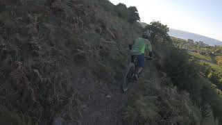
Partiendo desde el Portillo de Oceja tomamos un sendero a nuestra izquierda. Tras pasar una puerta para ganado - y volver a cerrarla - ganamos velocidad hasta llegar a una zona técnica a media ladera y con subes y bajas que tendremos que negociar hábilmente para no desmontar.
El tramo final gana pendiente y pasa por una escalera de madera que afianza el terreno. Llegamos al bidegorri cerca de la Playa de La Arena.

Tags
DropsSkinnies

Trail Supporters

Local Trail Association

Recent Activity on Trail

Past Week
  • 0 rides
  •  
6 Months
  • 1 rides
  • 61 miles avg distance
All
  • 20 rides
  • Last: Aug 4, 2026
c1c2c3c4
January
February
March
April
May
June
July
August
September
October
November
December
update trails status or condition

El Peñón Trail Reports

statusdatedescription
Nov 1, 2024 @ 1:03pm
Nov 1, 2024
reporter Camino cerrado por la vegetación
Mar 22, 2024 @ 4:43pm
Mar 22, 2024
reporter vegetación crecida y terreno alterado por el paso de ganado. Alguna zona de empujar la bici
Jan 15, 2021 @ 10:40am
Jan 15, 2021
Camino pisoteado por ganado estando húmedo, en algunas zonas esta impracticable. Hay un tramo de unos 3m que se ha caído ladera abajo
Sep 22, 2020 @ 11:59pm
Sep 22, 2020
reporter lleva un tiempo sin llover por lo que está todo bastante seco
Sep 6, 2020 @ 10:41am
Sep 6, 2020
Recorte del peligroso tocón de la parte central que impactaba con los pedales.
more »
Status:
on May 5, 2026
Avg: 3.98 (1 votes)
Your vote: 0

view (65)
close
      Directions to el-penon trailhead (43.340330, -3.104210)

      Photos

      47 more »
      mtb
      69 |
      Mar 4, 2020 @ 10:09am
      Mar 4, 2020
      mtb
      78 |
      Mar 4, 2020 @ 10:07am
      Mar 4, 2020
      mtb
      81 |
      Mar 4, 2020 @ 10:07am
      Mar 4, 2020
      mtb
      69 |
      Mar 4, 2020 @ 10:07am
      Mar 4, 2020

      Videos

      1 more »
      Montaño Tc1
      mtb
      2:12 | 265 | Sep 3, 2020 , Santurtzi

      Routes with this trail

      more »
      ★ 3.0 • 22 miles • 4,806 ft • 18 • Loop •
      Un desafío en el que disfutaremos tanto de las subidas como de las bajadas más técnicas del entorno de...

      Trail Events

      Links

      4.0 ★★★★★
      1 Ratings
      5 ★
      4 ★ 100%
      3 ★
      2 ★
      1 ★

      2 Reviews & Comments

      jonjo
      Ufff, mejor no tocar, pese a ser un pr está cerrada y sucia. Las vacas han destrozado alguna parte del sendero y tiene bastantes zarzas. No merece.
      jonjo
      Disfrutona y técnica bajada con sube bajas y media laderas. Está un poco escalonada en zonas. Una zona de escaleras en pendiente que se sortean por fuera. Bastante Recomendable para seguir bajando de Montaño hasta el bidé Gorri.

      We hope you've been enjoying Trailforks!

      Create a FREE account to view all trail reviews and much more.

      • By IMBAEuskadiTF Pro & contributors
      • #261718 - 1,189 views

      Frequently Asked Questions

      ▼ Where is El Peñón located?
      El Peñón is located in Ezkerraldea Kosta, Santurtzi, Spain. It is part of the Ezkerraldea Kosta trail network. The trailhead is located at coordinates 43.34033, -3.10421.
      ▼ How hard is El Peñón?
      El Peñón is rated as Red difficulty. The average grade is 9.8%.
      ▼ What is the elevation gain for El Peñón?
      The trail has 282 ft of elevation descent. The elevation ranges from 33 ft to 317 ft.
      ▼ Is El Peñón a point to point trail?
      Yes, El Peñón is a point to point trail. The direction is Downhill Only. The trail type is singletrack.
      ▼ How long is El Peñón?
      El Peñón is 2,887 ft long. The trail type is singletrack.
      ▼ Are dogs allowed on El Peñón?
      Yes, dogs are allowed on El Peñón. Please keep dogs on a leash where required and clean up after them.
      ▼ When is the best time of year to ride El Peñón?
      Based on activity log data, the most popular months to ride El Peñón are:
      • March (1 activities)
      • August (1 activities)
      Check the reports page for current trail conditions.
      ▼ How do I access El Peñón? Where is the closest parking trailhead?
      The closest parking and trailhead locations to El Peñón are: View all parking locations in the area.
      ▼ How long does it take to ride El Peñón?
      Based on recorded activities, it takes an average of 5 minutes to ride El Peñón. The trail is 2,887 ft long. Actual times will vary based on fitness level, conditions, and pace. View recent activity logs for more details.
      ▼ How busy is El Peñón?
      El Peñón is a less popular trail with lighter traffic. There have been 64 recorded activities on this trail. The trail has received 65 check-ins. View recent activity on this trail.

      Hit the Trail

      Open in App

      Get this trail on your phone instantly.

      open trail in app

      Download Trail

      Save to wishlist, Garmin & download.
      save the trail

      Find Related Routes

      Find routes and users activities that include this trail.
      find routes for this trail

      You must enter a description before submitting.

