more stats
1.0 mile
Distance
117 ft
Climb
-331 ft
Descent
00:11:21
Avg time
-213 ft
Altitude change
4,301 ft
Altitude min
4,625 ft
Altitude max
4,515 ft
Altitude start
4,301 ft
Altitude end
-3.9%
Grade
-36.4%
Grade max
29.7%
Grade min
1,591 ft
Distance climb
3,451 ft
Distance down
344 ft
Distance flat
00:11:21
Avg time

Eye Candy Details

  • Activities
    • Mountain Bike
    • Hike
    • Trail Running
  • Riding Area
    #2 Canyon
    Wenatchee, Washington
  • Difficulty Rating
  • Local Popularity
    90 in Mountain Biking [+]
    • 70 in Trail Running
    • 75 in Hiking
  • Global Ranking
    #18698 in Mountain Biking [+]
    • #89381 in Trail Running
    • #88502 in Hiking
  • Hiking SAC Scale
    T1 Hiking
  • Trail Type
    Singletrack
  • Direction
    Both Directions
    Popular Direction Shown
  • Climb Difficulty
    Blue
  • Dogs Allowed
    Yes
  • eBike Allowed

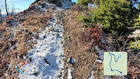
Built in 2021, this trail leaves just below the summit of Twin Peaks and climbs for 1/4 mile before descending down to the top of the newly rebuilt Sundance. Expect this trail to be a bit rougher than other trails in the area until it has more tires on it and gets packed down. It is a solid blue descent with great views, a few berms and eventually will be fast and flowy.

Local Trail Association
Traditionally Indigenous Territory

Recent Activity on Trail

Past Week
  • 5 rides
  • 13 miles average
6 Months
  • 90 rides
  • 19 miles avg distance
All
  • 515 rides
  • Last: Jun 30, 2026
c1c2c3c4
January
February
March
April
May
June
July
August
September
October
November
December
update trails status or condition

Eye Candy Trail Reports

statusdatedescription
Apr 15, 2026 @ 12:03am (America/Los_Angeles)
Apr 15, 2026
Dec 1, 2025 @ 7:47am (America/Los_Angeles)
Dec 1, 2025
All trails in Number Two Canyon are under a seasonal closure by the Forest Service from 12/1 until 4/15 for mule deer migration and to protect the...
Nov 7, 2025 @ 10:34am (America/Vancouver)
Nov 7, 2025
Beautiful views today. Trail has a half inch of snow where shaded. Video of the views...
Nov 4, 2025 @ 9:28am (America/Los_Angeles)
Nov 4, 2025
Open again after the Labor Mt fire. Please ride responsibly when conditions are variable
Sep 30, 2025 @ 2:42pm (America/Los_Angeles)
Sep 30, 2025
reporter https://www.fs.usda.gov/r06/okanogan-wenatchee/alerts/labor-mountain-fire-closure-updated-sept-30-2025-impacting-wenatchee
more »
Status:
on Apr 15, 2026
Avg: 3.69 (4 votes)
Your vote: 0

view (1,814)
close
3D
Trail Conditions
  • Unknown
  • Snow Groomed
  • Snow Packed
  • Snow Covered
  • Snow Cover Partial
  • Freeze/thaw Cycle
  • Icy
  • Prevalent Mud
  • Wet
  • Variable
  • Ideal
  • Dry
  • Very Dry
Trail Flow (Ridden Direction)
Trailforks scans users ridelogs to determine the most popular direction each trail is ridden. A good flowing trail network will have most trails flowing in a single direction according to their intension.
The colour categories are based on what percentage of riders are riding a trail in its intended direction.
  • > 96%
  • > 90%
  • > 80%
  • > 70%
  • > 50%
  • < 50%
  • bi-directional trail
  • no data
Trail Last Ridden
Trailforks scans ridelogs to determine the last time a trail was ridden.
  • < 2 days
  • < 1 week
  • < 2 weeks
  • < 1 month
  • < 6 months
  • > 6 months
Trail Ridden Direction
The intended direction a trail should be ridden.
  • Downhill Only
  • Downhill Primary
  • Both Directions
  • Uphill Primary
  • Uphill Only
  • One Direction
Contribute Details
Colors indicate trail is missing specified detail.
  • Description
  • Photos
  • Description & Photos
  • Videos
Trail Popularity ?
Trailforks scans ridelogs to determine which trails are ridden the most in the last 9 months. Trails are compared with nearby trails in the same city region with a possible 25 colour shades. Think of this as a heatmap, more rides = more kinetic energy = warmer colors.
  • most popular
  • popular
  • less popular
  • not popular
ATV/ORV/OHV Filter
Max Vehicle Width
inches
US Cell Coverage
Legend
cell carrier legend

Radar Time
Activity Recordings
Trailforks uses anonymized public activity data. ?
Activity Recordings
Trailforks uses anonymized public activity data. ?
Personal Heatmap
Activity Types
all / none
Options
2
Date range month
Winter Trails
Warning A routing network for winter maps does not exist. Selecting trails using the winter trails layer has been disabled.
Missing Trails
Most Popular
Least Popular
Trails are colored based on popularity. The more popular a trail is, the more red. Less popular trails trend towards green.
Jump Magnitude Heatmap
Heatmap of where riders jump on trails. Zoom in to see individual jumps, click circles to view jump details.
BC Backroad Status

Service Road Atlas is a free to use, community-driven service for viewing and creating reports on the numerous back-country service roads around B.C. and Alberta.

map legend
Slope Aspect
Direction the slope faces
Flat N NE E SE S SW W NW
Trails Deemphasized
Trails are shown in grey.
disable
Only show trails with no bike usage.
Enable
Suggested Layers
Based on selected activity type

    Save the current map location and zoom level as your default home location whenever this page is loaded.

    Save
        Directions to eye-candy trailhead (47.420260, -120.440290)

        Photos

        8 more »
        50 |
        Aug 8, 2024 @ 1:39pm
        Aug 8, 2024
        41 |
        Aug 8, 2024 @ 1:38pm
        Aug 8, 2024
        37 |
        Aug 8, 2024 @ 1:38pm
        Aug 8, 2024
        46 |
        Aug 8, 2024 @ 1:37pm
        Aug 8, 2024

        Videos

        3 more »
        I'm here for the Wildflowers!
        17:16 | 107 | Aug 5, 2024 , Wenatchee
        Eye Candy - #2 Canyon - Wenatchee, Washington
        5:06 | 351 | Oct 6, 2022 , Wenatchee
        Slow Eye Candy Descent For The Views
        3:39 | 100 | Nov 7, 2025 , Wenatchee

        Routes with this trail

        13 miles 2,419 ft 9 Loop
        Outer loop, staying on , , and Inconceivable.
        22 miles 4,589 ft 18 Loop
        CCW Loop of Twin Peaks Summit
        16 miles 2,639 ft 12
        Stairway, Dragontail, Twin Peaks, EVH, New Sundance, Double D, Bootleg, loop, and back

        3 Reviews & Comments


        We hope you've been enjoying Trailforks!

        Create a FREE account to view trail comments and much more.

        • By bradakTF Pro & contributors
        • #455593 - 1,819 views

        Frequently Asked Questions About Eye Candy

        Where is Eye Candy located?
        Eye Candy is located in #2 Canyon, Wenatchee, Washington, United States. It is part of the #2 Canyon trail network. The trailhead is located at coordinates 47.42026, -120.44029.
        How hard is Eye Candy?
        Eye Candy is rated as Blue difficulty. The average grade is 3.9%. The climb difficulty is rated Blue.
        What is the elevation gain for Eye Candy?
        Eye Candy has 117 ft of elevation gain. The trail has 331 ft of elevation descent. The elevation ranges from 4,301 ft to 4,625 ft.
        Is Eye Candy a point to point trail?
        Eye Candy is not a point to point trail. The direction is Both Directions. The trail type is singletrack.

        Hit the Trail

        Open in App

        Get this trail on your phone instantly.
        open trail in app

        Download Trail

        Save to wishlist, Garmin & download.
        save the trail

        Find Related Routes

        Find routes and users activities that include this trail.
        find routes for this trail

        You must enter a description before submitting.