more stats
2,411 ft
Distance
-573 ft
Descent
00:03:38
Avg time
-573 ft
Altitude change
714 ft
Altitude min
1,287 ft
Altitude max
1,287 ft
Altitude start
715 ft
Altitude end
-23.8%
Grade
-49%
Grade max
-0.7%
Grade min
2,303 ft
Distance down
59 ft
Distance flat
00:03:38
Avg time

Flat White - (1) Details

  • Activities
    • Mountain Bike
    • E-Bike
  • Riding Area
    Caberston
    Innerleithen
  • Difficulty Rating
  • Voted Difficulty
    Red (2 votes)
  • Local Popularity
    100 in Mountain Biking [+]
    • 100 in E-Biking
  • Global Ranking
    #318 in Mountain Biking [+]
    • #1702 in E-Biking
  • Trail Type
    Singletrack
  • Bike Type
    AM, XC
  • Direction
    One Direction
    Popular Direction Shown
  • Physical Rating
    Hard
  • Trail Visibility
    Always easy to follow
  • eBike Allowed
    Yes up to Class 1
  • TTFs on Trail
    Berm, Jump, Rock Garden
  • Year Opened
    2015
  • Land Owner
    Forest and Land Scotland

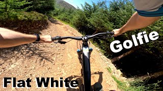
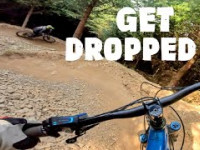
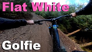
WAS : "Berm, Berm, Berm, Berm, Rock garden, Berm, Berm, Jump, Jump, Berm, steep chute, (brake pads gone), berm, berm, Finish, Fall over.

Hugely over simplified but you get the general idea. For realism throw in a healthy dose of steep, a scattering of scree and a handful of religious expletives."

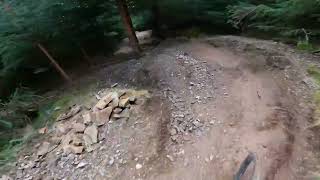
NOW: "Revamped over the period of a year. Reopened 28th October 2024. Entire trail has been rebuilt and is now an entry level trail, easier than NYNY. Berms for days. All drops are rollable, optional jump off the main line and the steep exit chute has been replaced with a more mellow ending."

This trail is unsanctioned.

Trail Supporters

Recent Activity on Trail

Past Week
  • 7 rides
  • 17 miles average
6 Months
  • 178 rides
  • 16 miles avg distance
All
  • 918 rides
  • Last: Jul 3, 2026
c1c2c3c4
January
February
March
April
May
June
July
August
September
October
November
December
Status:
on Jun 20, 2026
Variable
Avg: 4.36 (46 votes)
Your vote: 0

view (14,020)
close
3D
Trail Conditions
  • Unknown
  • Snow Groomed
  • Snow Packed
  • Snow Covered
  • Snow Cover Partial
  • Freeze/thaw Cycle
  • Icy
  • Prevalent Mud
  • Wet
  • Variable
  • Ideal
  • Dry
  • Very Dry
Trail Flow (Ridden Direction)
Trailforks scans users ridelogs to determine the most popular direction each trail is ridden. A good flowing trail network will have most trails flowing in a single direction according to their intension.
The colour categories are based on what percentage of riders are riding a trail in its intended direction.
  • > 96%
  • > 90%
  • > 80%
  • > 70%
  • > 50%
  • < 50%
  • bi-directional trail
  • no data
Trail Last Ridden
Trailforks scans ridelogs to determine the last time a trail was ridden.
  • < 2 days
  • < 1 week
  • < 2 weeks
  • < 1 month
  • < 6 months
  • > 6 months
Trail Ridden Direction
The intended direction a trail should be ridden.
  • Downhill Only
  • Downhill Primary
  • Both Directions
  • Uphill Primary
  • Uphill Only
  • One Direction
Contribute Details
Colors indicate trail is missing specified detail.
  • Description
  • Photos
  • Description & Photos
  • Videos
Trail Popularity ?
Trailforks scans ridelogs to determine which trails are ridden the most in the last 9 months. Trails are compared with nearby trails in the same city region with a possible 25 colour shades. Think of this as a heatmap, more rides = more kinetic energy = warmer colors.
  • most popular
  • popular
  • less popular
  • not popular
ATV/ORV/OHV Filter
Max Vehicle Width
inches
US Cell Coverage
Legend
cell carrier legend

Radar Time
Activity Recordings
Trailforks uses anonymized public activity data. ?
Activity Recordings
Trailforks uses anonymized public activity data. ?
Personal Heatmap
Activity Types
all / none
Options
2
Date range month
Winter Trails
Warning A routing network for winter maps does not exist. Selecting trails using the winter trails layer has been disabled.
Missing Trails
Most Popular
Least Popular
Trails are colored based on popularity. The more popular a trail is, the more red. Less popular trails trend towards green.
Jump Magnitude Heatmap
Heatmap of where riders jump on trails. Zoom in to see individual jumps, click circles to view jump details.
BC Backroad Status

Service Road Atlas is a free to use, community-driven service for viewing and creating reports on the numerous back-country service roads around B.C. and Alberta.

map legend
Slope Aspect
Direction the slope faces
Flat N NE E SE S SW W NW
Trails Deemphasized
Trails are shown in grey.
disable
Only show trails with no bike usage.
Enable
Suggested Layers
Based on selected activity type

    Save the current map location and zoom level as your default home location whenever this page is loaded.

    Save
        Directions to flat-white--1 trailhead (55.637690, -3.043890)

        Photos

        6 more »
        158 |
        Jun 1, 2024 @ 5:44am
        Jun 1, 2024
        734 |
        Jan 19, 2018 @ 8:00am
        Jan 19, 2018
        498 |
        Jun 12, 2017 @ 1:59pm
        Jun 12, 2017
        793 |
        May 23, 2016 @ 4:48pm
        May 23, 2016

        Videos

        30 more »
        Flat White - Golfie - Summer 2025
        2:32 | 222 | Jul 15, 2025 , Innerleithen
        Flat White | Golfie MTB Trail Series with the Lad
        108 | Jun 19, 2025 , Innerleithen
        Flat White - Golfie 2025
        3:02 | 136 | Feb 24, 2025 , Innerleithen
        Flat White-the golfie Innerleithen-
        2:27 | 68 | Feb 23, 2025 , Innerleithen

        Routes with this trail

        27 miles 3,701 ft 79 Loop
        Epic 3 hills route through the Tweed Valley
        5.0 39 miles 9,224 ft 41 Loop Race
        Route of the Tweed Valley round of the 2022 E-Enduro World Series. Thursday 3rd June 2022 NYNY 1km -230m...

        3 Reviews & Comments


        We hope you've been enjoying Trailforks!

        Create a FREE account to view trail comments and much more.

        • #56510 - 18,417 views

        Frequently Asked Questions About Flat White - (1)

        Where is Flat White - (1) located?
        Flat White - (1) is located in Caberston, Innerleithen, United Kingdom. It is part of the Caberston trail network. The trailhead is located at coordinates 55.63769, -3.04389.
        How hard is Flat White - (1)?
        Flat White - (1) is rated as Red difficulty. The physical rating is Hard. The average grade is 23.8%.
        What is the elevation gain for Flat White - (1)?
        The trail has 573 ft of elevation descent. The elevation ranges from 714 ft to 1,287 ft.
        Is Flat White - (1) a point to point trail?
        Yes, Flat White - (1) is a point to point trail. The direction is One Direction. The trail type is singletrack.

        Hit the Trail

        Open in App

        Get this trail on your phone instantly.
        open trail in app

        Download Trail

        Save to wishlist, Garmin & download.
        save the trail

        Find Related Routes

        Find routes and users activities that include this trail.
        find routes for this trail

        You must enter a description before submitting.