




Open in App
Get this trail on your phone instantly.

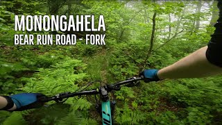
This is an epic remote ridge ride that has it all. it is mostly traveled east to west, ending in Richwood. in this direction it has more downhill than up as it encompasses the western 13 miles of cleared Fork Mountain Trail. It was once an old road that has constricted into a great singletrack. It's still possible to see the stones that were hand laid during the CCC days.
As it follows the ridge, the trail travels through several rhododendron tunnels, so Summer and Autumn are some of the best times to ride and enjoy the scenery. In the winter months, its very wet.
.
There are multiple ways to access/ride this trail. Bear Run Road (FR 223), Pocahontas Trail, North Bend Trail, Marlinton Road
Set a shuttle in Richwood, then drive east on Hwy 39/55 to Kennison Mtn. Begin at the Kennison Mtn parking lot and cross Hwy 39/55 heading south on Kennison Mountain Trail skirting Blue Knob to the west. Turn right on Pocahontas Trail #263, crossing a grassy road heading west. At the intersection of Pocahontas Trail #263 and Fork Mountain Trail - East Section, go left.
Follow the singletrack for a climb and descent that leads over Hill Creek (rideable unless just after a rain). When you encounter a paved trail, follow it to the Falls of Hills Creek parking lot. From there, continue to Highway 39/55 and turn left (west) for just over a mile-and-a-half of easy paved pedaling to reach Bear Run Road.
A four mile gravel road climb takes riders to the top of Fork Mountain and handily avoids the Fork Mountain Trail - Water Bar Section which would be absolute misery to try and climb because of the massive water bars. At the top, continue on the Fork Mountain Trail - Ridge Section for 13-miles of rugged and scenic singletrack that follows the trace of a hand-laid road.
When you come to the gravel road (FSR #946), turn left and follow it down to a yellow metal gate which you can pass on the right, turn right and follow the paved road into Richwood. You can also cross the gravel road and continue across a grassy area to the 3 mile downhill final section of Fork. There is typically mud in a flat area that will be fixed in the next couple of years with a bridge and a ride around.
You can ride this as a 72-mile loop for the very fit, known locally as the Yew Mountain Doozy - check its Facebook page. Yes, there really is one, https://www.facebook.com/WVDoozy
| c1 | c2 | c3 | c4 |
|---|---|---|---|
January | February | March | April |
May | June | July | August |
September | October | November | December |

Service Road Atlas is a free to use, community-driven service for viewing and creating reports on the numerous back-country service roads around B.C. and Alberta.
Save the current map location and zoom level as your default home location whenever this page is loaded.
SaveWe hope you've been enjoying Trailforks!
Create a FREE account to view all trail reviews and much more.
 & contributors
You must enter a description before submitting.

