


Open in App
Get this trail on your phone instantly.

Forum Tower Loop was added in October 2020 and can be used as a single 1 mile loop or as an extension of Iwen North and Iwen South for total of approximately 7 miles or approximately 35-60 minutes at a reasonable pace.
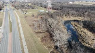
Forum Tower Loop starts just south of the Forum Communications Tower near the intersection of 40th Ave S and University Drive. The trail heads east towards the river from the University Drive ditch, then turns north to run beside the river until it reaches the edge of the Forum Communications property, then runs west up onto the edge of the dike straight up from 40th Ave, then loops back south and west to University Drive.
Forum Tower Loop trail is great for biking & hiking. It has nice views of the river and the drain 27 river mouth. Deer and squirrels are plentiful in the area and mountain bikers ride through frequently, so make sure dogs are on a leash.
Trail direction for bikers is indicated by the signage and is in a counter-clockwise orientation. Hikers are encouraged to walk opposite the bike traffic for easier visibility.
The terrain is mostly wooded with good flow and a few short punchy climbs that roll back down and into the woods. By global standards this would be considered a green/easy difficulty, but by local standards its a solid blue trail.
Red River Valley soil is very clay based and the trail can become impossible to use when wet or muddy. Please don't ride when wet. If wet then it will be sticky, slippery, and will rut easily.
Forum Tower Loop can be ridden as a single one mile loop or, by riding over the Drain 27 bridge, it can be ridden as an extension of the Iwen North trail, that runs from Lions Conservancy to Iwen Boat Landing, and Iwen South, that runs from Iwen Boat Landing to 58th Ave S, for total of approximately 7 miles or approximately 35-60 minutes at a reasonable pace.
Access from the Northwest corner of Iwen North in Lions Conservancy by climbing up the University Drive ditch onto the sidewalk, cross Rose Creek Coulee, and the entrance is on the immediate right after the bridge.
An optional north entrance/exit is immediately over the dike from 40th Ave S.

| c1 | c2 | c3 | c4 |
|---|---|---|---|
January | February | March | April |
May | June | July | August |
September | October | November | December |

Service Road Atlas is a free to use, community-driven service for viewing and creating reports on the numerous back-country service roads around B.C. and Alberta.
Save the current map location and zoom level as your default home location whenever this page is loaded.
SaveWe hope you've been enjoying Trailforks!
Create a FREE account to view all trail reviews and much more.
 FMTB & contributors
You must enter a description before submitting.

