


more stats
2.7 miles
Distance
130 ft
Climb
-2,427 ft
Descent
00:39:22
Avg time
-2,297 ft
Altitude change
804 ft
Altitude min
3,100 ft
Altitude max
3,100 ft
Altitude start
804 ft
Altitude end
-16.2%
Grade
-75.7%
Grade max
35.6%
Grade min
1,253 ft
Distance climb
2 miles
Distance down
440 ft
Distance flat
00:39:22
Avg time

Giù la testa Details

  • Activities
    • Mountain Bike
    • E-Bike
    • Hike
    • Trail Running
  • Riding Area
    Grigna Meridionale
    Abbadia Lariana
  • Difficulty Rating
  • Voted Difficulty
    Red (3 votes)
  • Local Popularity
    85 in Mountain Biking heatmap [+]
    • 100 in E-Biking
    • 5 in Trail Running
    • 40 in Hiking
  • Global Ranking
    #43115 in Mountain Biking [+]
    • #13426 in E-Biking
    • #350507 in Trail Running
    • #155036 in Hiking
  • National Ranking
    #4,044 in Mountain Biking · Italy [+]
    • #1,596 in E-Biking
    • #13,369 in Trail Running
    • #4,836 in Hiking
  • Hiking SAC Scale
    T2 Mountain Hiking
  • Trail Type
    Singletrack
  • Bike Type
    DH, AM, XC
  • Direction
    Downhill Only
  • Physical Rating
    Hard
  • Trail Visibility
    Sometimes hard to follow
  • Alpine Trail
    Yes
  • Dogs Allowed
    Yes
  • eBike Allowed
    Yes up to Class 1
  • TTFs on Trail
    Berm, Drop, Rock Face, Rock Garden, Skinny, Other

Natural trail, with some technical steps, some switchback, rock garden, steep sections.

Good riding technique needed.

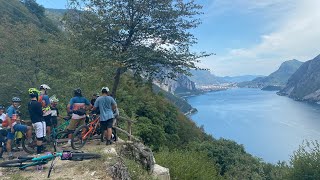
Very nice panoramic points on the lake.

(resinelli/abbadia)

Access Info

Colonghelli - Piani Resinelli

Disclaimer

Ride at your own risk

Local Trail Association

Recent Activity on Trail

Past Week
  • 0 rides
  •  
6 Months
  • 2 rides
  • 12 miles avg distance
All
  • 58 rides
  • Last: Oct 11, 2026
c1c2c3c4
January
February
March
April
May
June
July
August
September
October
November
December
update trails status or condition

Giù la testa Trail Reports

statusdatedescription
Jun 27, 2026 @ 10:22am (Europe/Vaduz)
Jun 27, 2026
reporter
Jun 7, 2026 @ 11:47am (Europe/Vaduz)
Jun 7, 2026
Very Slippery
Mar 8, 2026 @ 6:19pm (Europe/Rome)
Mar 8, 2026
Terreno asciutto in condizioni ottimali, qualche foglia, ma non da creare problemi
Jul 28, 2025 @ 4:28am
Jul 28, 2025
reporter Un disastro
Jun 19, 2025 @ 7:45am
Jun 19, 2025
reporter Fondo secco, erba in alcuni punti alta ma non da fastidio. Solo un paio di punti dove bisogna scendere per piante schiantate.
more »
Status:
on Jun 27, 2026
Ideal
Avg: 4.15 (9 votes)
Your vote: 0

view (232)
close
      Directions to giu-la-testa trailhead (45.910250, 9.365800)

      Photos

      8 more »
      mtb
      282 |
      Aug 26, 2022 @ 7:53am
      Aug 26, 2022
      mtb
      291 |
      Aug 26, 2022 @ 7:53am
      Aug 26, 2022
      mtb
      345 |
      Mar 16, 2022 @ 4:18pm
      Mar 16, 2022
      report
      mtb
      114 |
      Jul 5, 2024 @ 5:53am
      Jul 5, 2024

      Videos

      3 more »
      North n Line Afternoon ride 2022
      mtb
      3:44 | 441 | May 1, 2023 , Abbadia Lariana
      Giù la testa - Mica male eh!!
      mtb
      2:26 | 523 | Apr 18, 2023 , Abbadia Lariana
      GLT Enduro
      mtb
      8:52 | 596 | Apr 18, 2023 , Abbadia Lariana
      4.5 ★★★★★
      9 Ratings
      5 ★ 44%
      4 ★ 56%
      3 ★
      2 ★
      1 ★

      4 Reviews & Comments

      ArteBici ArteBici
      Bella discesa che varia da S2 a S3 a seconda del tratto
      poporni poporni
      sentiero natural che ha tutto, dal flow al tecnico. sicuramente impegnativo ma divertente. tra i più belli in provincia di Lecco
      marionide marionide
      Molto natural, con tratti scassati e rocce sporgenti che insidiano il cambio. Per gli amanti del genere

      We hope you've been enjoying Trailforks!

      Create a FREE account to view all trail reviews and much more.

      • By Dariollo78TF Pro & contributors
      • #214780 - 3,704 views

      Frequently Asked Questions

      ▼ Where is Giù la testa located?
      Giù la testa is located in Grigna Meridionale, Abbadia Lariana, Italy. It is part of the Grigna Meridionale trail network. The trailhead is located at coordinates 45.91025, 9.3658.
      ▼ How hard is Giù la testa?
      Giù la testa is rated as Red difficulty. The physical rating is Hard. The average grade is 16.2%.
      ▼ What is the elevation gain for Giù la testa?
      Giù la testa has 130 ft of elevation gain. The trail has 2,427 ft of elevation descent. The elevation ranges from 804 ft to 3,100 ft.
      ▼ Is Giù la testa a point to point trail?
      Yes, Giù la testa is a point to point trail. The direction is Downhill Only. The trail type is singletrack.
      ▼ How long is Giù la testa?
      Giù la testa is 2.7 miles long. The trail type is singletrack.
      ▼ Are dogs allowed on Giù la testa?
      Yes, dogs are allowed on Giù la testa. Please keep dogs on a leash where required and clean up after them.
      ▼ When is the best time of year to ride Giù la testa?
      Based on activity log data, the most popular months to ride Giù la testa are:
      • October (5 activities)
      • May (4 activities)
      • January (2 activities)
      Check the reports page for current trail conditions.
      ▼ How do I access Giù la testa? Where is the closest parking trailhead?
      The closest parking and trailhead locations to Giù la testa are: View all parking locations in the area.
      ▼ How long does it take to ride Giù la testa?
      Based on recorded activities, it takes an average of 39 minutes to ride Giù la testa. The trail is 2.7 miles long. Actual times will vary based on fitness level, conditions, and pace. View recent activity logs for more details.
      ▼ How busy is Giù la testa?
      Giù la testa is a very popular trail. There have been 235 recorded activities on this trail. The trail has received 232 check-ins. View recent activity on this trail.

      Hit the Trail

      Open in App

      Get this trail on your phone instantly.

      open trail in app

      Download Trail

      Save to wishlist, Garmin & download.
      save the trail

      Find Related Routes

      Find routes and users activities that include this trail.
      find routes for this trail

      You must enter a description before submitting.