
more stats
2,858 ft
Distance
4 ft
Climb
-639 ft
Descent
00:04:49
Avg time
-635 ft
Altitude change
2,594 ft
Altitude min
3,229 ft
Altitude max
3,229 ft
Altitude start
2,595 ft
Altitude end
-22.2%
Grade
-58.9%
Grade max
6.5%
Grade min
125 ft
Distance climb
2,733 ft
Distance down
00:04:49
Avg time

Gnarwahl Details

  • Activities
    • Mountain Bike
    • E-Bike
    • Hike
    • Trail Running
  • Riding Area
    Harper Mountain
    Kamloops, British Columbia
  • Difficulty Rating
  • Trail Style
    Technical
  • Local Popularity
    85 in Mountain Biking heatmap [+]
    • 70 in E-Biking
    • 5 in Trail Running
    • 5 in Hiking
  • Global Ranking
    #41731 in Mountain Biking [+]
    • #31022 in E-Biking
    • #218248 in Trail Running
    • #216579 in Hiking
  • Provincial Ranking
    #2,045 in Mountain Biking · British Columbia [+]
    • #2,102 in E-Biking
    • #11,852 in Trail Running
    • #11,571 in Hiking
  • Trail Type
    Singletrack
  • Bike Type
    DH, AM
  • Physical Rating
    Moderate
  • Trail Visibility
    Always easy to follow
  • Dogs Allowed
    Yes
  • eBike Allowed
    Yes up to Class 1
  • Land Owner
    Rec Sites and Trails BC

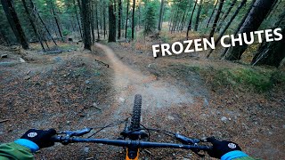
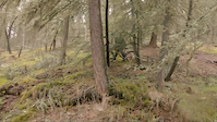
A steep, "raw" fall line trail. Be prepared to be on the brakes and hanging off the back as you try to pick the best lines through the chunder.

Tags

Local Trail Association

Traditionally Indigenous Territory

Recent Activity on Trail

Past Week
  • 0 rides
  •  
6 Months
  • 66 rides
  • 11 miles avg distance
All
  • 212 rides
  • Last: Nov 11, 2026
c1c2c3c4
January
February
March
April
May
June
July
August
September
October
November
December
update trails status or condition

Gnarwahl Trail Reports

statusdatedescription
May 2, 2026 @ 4:49pm (America/Vancouver)
May 2, 2026
reporter n The Harper Mountain network is opefor the season as of May 1.
Nov 29, 2025 @ 4:04am (America/Vancouver)
Nov 29, 2025
reporter the Harper Mountain bike trails are closed for the 2024 season, they'll reopen in spring 2025 once they're snow free.
Sep 29, 2025 @ 8:40am (America/Vancouver)
Sep 29, 2025
reporter Trail status - all clear and open again.
Sep 28, 2025 @ 10:54am (America/Vancouver)
Sep 28, 2025
Jul 30, 2025 @ 9:13pm
Jul 30, 2025
reporter There's a phone/power line down across the trail. Appropriate authorities have been notified and we're waiting on them to remove the line. Please...
more »
Status:
on May 2, 2026
Variable
Avg: 4.16 (12 votes)
Your vote: 0

view (1,201)
close
      Directions to gnarwahl trailhead (50.729220, -120.165270)

      Photos

      6 more »
      mtb
      162 |
      Jun 23, 2021 @ 7:07am
      Jun 23, 2021
      mtb
      234 |
      Dec 16, 2020 @ 10:45pm
      Dec 16, 2020
      report
      mtb
      99 |
      Apr 25, 2024 @ 5:25pm
      Apr 25, 2024

      Videos

      6 more »
      The Steepest Trail at Harper Mountain
      mtb
      2:37 | 329 | Dec 22, 2021 , Kamloops
      Double Crash
      mtb
      0:13 | 85 | Jul 2, 2022 , Kamloops
      Mud Slide Fail
      mtb
      0:18 | 101 | Jul 2, 2022 , Kamloops
      Mud Slide Fail 2
      mtb
      0:09 | 114 | Jul 2, 2022 , Kamloops
      4.3 ★★★★★
      12 Ratings
      5 ★ 33%
      4 ★ 58%
      3 ★ 8%
      2 ★
      1 ★

      6 Reviews & Comments

      Crakkerz
      Trail is in great shape for early summer. Top section from meadow/parking lot is open. Flowy connector from the bottom over to Nate's exit has been reworked and is very flowy, with emphasis on speed over air.
      kyleluvsdh kyleluvsdh
      Unicorn DH into Gnarwahl is such a good DH lap! Harper rips, thanks builders! \m/ Big Grin
      cdnmtbkr cdnmtbkr
      As of PM 2023-05-12: Gnarwal closed at entrance (taped off and signed at entrance and exit at first road crossing) but seems to be open at road crossing (section from road crossing to lower parking is open), as it was not taped off at the road.

      We hope you've been enjoying Trailforks!

      Create a FREE account to view all trail reviews and much more.

      • By henkvanzylTF Pro & contributors
      • #37489 - 4,111 views

      Frequently Asked Questions

      ▼ Where is Gnarwahl located?
      Gnarwahl is located in Harper Mountain, Kamloops, British Columbia, Canada. It is part of the Harper Mountain trail network. The trailhead is located at coordinates 50.72922, -120.16527.
      ▼ How hard is Gnarwahl?
      Gnarwahl is rated as Black Diamond difficulty. The physical rating is Moderate. The average grade is 22.2%.
      ▼ What is the elevation gain for Gnarwahl?
      Gnarwahl has 4 ft of elevation gain. The trail has 639 ft of elevation descent. The elevation ranges from 2,594 ft to 3,229 ft.
      ▼ How long is Gnarwahl?
      Gnarwahl is 2,858 ft long. The trail type is singletrack.
      ▼ Are dogs allowed on Gnarwahl?
      Yes, dogs are allowed on Gnarwahl. Please keep dogs on a leash where required and clean up after them.
      ▼ How do I access Gnarwahl? Where is the closest parking trailhead?
      The closest parking and trailhead locations to Gnarwahl are: View all parking locations in the area.
      ▼ How long does it take to ride Gnarwahl?
      Based on recorded activities, it takes an average of 5 minutes to ride Gnarwahl. The trail is 2,858 ft long. Actual times will vary based on fitness level, conditions, and pace. View recent activity logs for more details.
      ▼ How busy is Gnarwahl?
      Gnarwahl is a very popular trail. There have been 1,137 recorded activities on this trail. The trail has received 1,201 check-ins. View recent activity on this trail.

      Hit the Trail

      Open in App

      Get this trail on your phone instantly.

      open trail in app

      Download Trail

      Save to wishlist, Garmin & download.
      save the trail

      Find Related Routes

      Find routes and users activities that include this trail.
      find routes for this trail

      You must enter a description before submitting.