


more stats
3.0 miles
Distance
247 ft
Climb
-387 ft
Descent
00:16:29
Avg time
-140 ft
Altitude change
755 ft
Altitude min
895 ft
Altitude max
895 ft
Altitude start
755 ft
Altitude end
-0.9%
Grade
-27.3%
Grade max
13.4%
Grade min
1 mile
Distance climb
1 mile
Distance down
2,999 ft
Distance flat
00:16:29
Avg time

Humpular Trail Details

  • Activities
    • Mountain Bike
    • Winter Fat Bike
    • Hike
    • Trail Running
  • Riding Area
    Pittsburgh
    , Pennsylvania
  • AKA
    Crater Trail
  • Difficulty Rating
  • Voted Difficulty
    Black Diamond (6 votes)
  • Local Popularity
    95 in Mountain Biking heatmap [+]
    • 60 in Trail Running
    • 90 in Hiking
    • 5 in Winter Fat Biking
  • Global Ranking
    #1835 in Mountain Biking [+]
    • #119756 in Trail Running
    • #80747 in Hiking
    • #1932 in Winter Fat Biking
  • State Ranking
    #12 in Mountain Biking · Pennsylvania [+]
    • #1,844 in Trail Running
    • #1,389 in Hiking
    • #2 in Winter Fat Biking
  • Trail Exposure
    High Risk
  • Trail Type
    Singletrack
  • Bike Type
    AM, XC, Fat
  • Climb Difficulty
    Black Diamond
  • Physical Rating
    Hard
  • Trail Visibility
    Always easy to follow
  • TTFs on Trail
    Berm, Drop, Jump, Gap Jump, Log Ride, Pump Track, Roller Coaster, Skinny
  • Lighting
    No

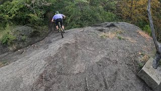
A flowy and feature laden trail following the hillside along the Mon river. THIS TRAIL IS ONE WAY.... BAD THINGS COULD HAPPEN IF RIDDEN BACKWARDS!! This trail has many high speed blind corners. It is recommended that hikers and runners travel in the opposite direction of the cyclists so they have visibility of oncoming traffic (hike in the counter-clockwise direction).

This trail is unsanctioned.

Traditionally Indigenous Territory

Recent Activity on Trail

Past Week
  • 2 rides
  • 21.1 km average
6 Months
  • 89 rides
  • 20.9 km avg distance
All
  • 572 rides
  • Last: Nov 11, 2026
c1c2c3c4
January
February
March
April
May
June
July
August
September
October
November
December
update trails status or condition

Humpular Trail Trail Reports

statusdatedescription
Aug 15, 2026 @ 10:54am (America/New_York)
Aug 15, 2026
Blowdown about 3/4s of the way up first part of trail, few tenths from Redemption turnoff.. too low to duck under
Apr 27, 2026 @ 8:48pm (America/New_York)
Apr 27, 2026
Will need a haircut in the next few weeks. Otherwise good no downed trees.
Oct 25, 2025 @ 7:41pm (America/New_York)
Oct 25, 2025
reporter The entrance is not as well defined as before, but the GPS track has been edited to match on the ground conditions.
Jul 21, 2025 @ 7:56am
Jul 21, 2025
Access via Nine Mile Trail is gated off by construction
Jul 10, 2025 @ 1:23pm
Jul 10, 2025
Construction completely destroyed the beginning of this trail :(
more »
Status:
on Aug 15, 2026
Variable
Avg: 4.73 (28 votes)
Your vote: 0

view (5,610)
close
      Directions to humpular-trail trailhead (40.418340, -79.912140)

      Photos

      41 more »
      mtb
      193 |
      Jun 5, 2025 @ 11:28am
      Jun 5, 2025
      mtb
      231 |
      Jun 5, 2025 @ 11:28am
      Jun 5, 2025
      mtb
      194 |
      Jun 5, 2025 @ 11:28am
      Jun 5, 2025
      mtb
      322 |
      May 21, 2024 @ 7:42am
      May 21, 2024

      Videos

      4 more »
      Redemption Center & Humpular
      mtb
      348 | Jun 1, 2023 , Pittsburgh
      Crater Humpular Father Son
      mtb
      17:56 | 972 | Feb 23, 2022 , Pittsburgh
      Frick Park | Humpular Slags | MTB 2020 Late Season
      mtb
      19:10 | 802 | Jun 10, 2021 , Pittsburgh
      Slag Booter
      mtb
      0:06 | 203 | Jun 17, 2025 , Pittsburgh

      Routes with this trail

      more »
      9 miles • 1,057 ft • 7 •
      This is a route with most of the popular trails in Frick Park, including Bradema and Iron Gate.
      6 miles • 509 ft • 8 • Loop •
      Humpular and Redemption Center in the Slags near Frick Park
      ★ 1.0 • 17 miles • 1,963 ft • 17 • Loop •
      This route covers most of the trails in Frick Park in the best direction to ride them.
      4.9 ★★★★★
      28 Ratings
      5 ★ 93%
      4 ★ 4%
      3 ★ 4%
      2 ★
      1 ★

      30 Reviews & Comments

      ChristophereSIJpw
      Great trail, especially once you know it. Took me 5 or so runs before I knew the flow well enough to confidently keep trail speed and clear some doubles. Like another comment said, just take it slow and hug the hillside the first few times because it's true that there are some blind corners along the narrow bench sections. A great trail to hone your pumping as it's really the only way to keep speed, otherwise prepare to pedal. And it's a great link-up with Redemption, which is a similarly awesome trail if you like to jump.
      pedalandphoto pedalandphoto
      This is a challenging trail, there are many spots that will bite you if you're not careful. Before riding here make sure you are able to ride the rest of the park with confidence. There's two bailouts, the first is in the beginning right after the initial downhill. The second is by the rollercoaster. If you don't take them you're signing up for the full 4 mile commitment. This is a rocking fun trail that makes me hoot and giggle the whole way. Everything is very well built, smooth, and designed expertly. Be aware there will be gaps, drops, and mega narrow parts that happen without warning. I'd say this trail is a single black with double black features, also double black exposure. There are by-passes for the toughest ones, the dirt part isn't so difficult unless you screw up. If you do you could fall 10-20' and parts are really exposed. Still I'd do this trail everyday, it puts a huge grin on my face.
      MichaelZX5LEv
      This trail is a lot of fun and not as hard as some of these comments made it seem. I would definitely be able to ride all of frick confidently and fast before touching this. Take it slow your first time but be warned, you will do an immense amount of pedaling. After that first time, just send it. The faster you go, the easier and more fun the trail ends up being. Hug the hillsides if your unsure about a corner and you’ll be fine.

      We hope you've been enjoying Trailforks!

      Create a FREE account to view all trail reviews and much more.

      • #59458 - 13,761 views

      Frequently Asked Questions

      ▼ Where is Humpular Trail located?
      Humpular Trail is located in Pittsburgh, Pennsylvania, United States. It is part of the Pittsburgh trail network. The trailhead is located at coordinates 40.41834, -79.91214.
      ▼ How hard is Humpular Trail?
      Humpular Trail is rated as Black Diamond difficulty. The physical rating is Hard. The average grade is 0.9%. The climb difficulty is rated Black Diamond.
      ▼ What is the elevation gain for Humpular Trail?
      Humpular Trail has 247 ft of elevation gain. The trail has 387 ft of elevation descent. The elevation ranges from 755 ft to 895 ft.
      ▼ How long is Humpular Trail?
      Humpular Trail is 3.0 miles long. The trail type is singletrack.
      ▼ Are dogs allowed on Humpular Trail?
      There is no information about dogs being allowed on Humpular Trail. Check with local trail managers or the trail page for the latest access rules.
      ▼ When is the best time of year to ride Humpular Trail?
      Based on activity log data, the most popular months to ride Humpular Trail are:
      • August (45 activities)
      • July (38 activities)
      • April (32 activities)
      Check the reports page for current trail conditions.
      ▼ How do I access Humpular Trail? Where is the closest parking trailhead?
      The closest parking and trailhead locations to Humpular Trail are: View all parking locations in the area.
      ▼ How long does it take to ride Humpular Trail?
      Based on recorded activities, it takes an average of 16 minutes to ride Humpular Trail. The trail is 3.0 miles long. Actual times will vary based on fitness level, conditions, and pace. View recent activity logs for more details.
      ▼ How busy is Humpular Trail?
      Humpular Trail is a very popular trail. There have been 5,461 recorded activities on this trail. The trail has received 5,610 check-ins. View recent activity on this trail.

      Hit the Trail

      Open in App

      Get this trail on your phone instantly.

      open trail in app

      Download Trail

      Save to wishlist, Garmin & download.
      save the trail

      Find Related Routes

      Find routes and users activities that include this trail.
      find routes for this trail

      You must enter a description before submitting.

