more stats
869 ft
Distance
-125 ft
Descent
00:02:10
Avg time
-125 ft
Altitude change
820 ft
Altitude min
945 ft
Altitude max
945 ft
Altitude start
820 ft
Altitude end
-14.3%
Grade
-31.1%
Grade max
745 ft
Distance down
95 ft
Distance flat
00:02:10
Avg time

Jaimito Extrem Details

  • Activities
    • Mountain Bike
    • E-Bike
    • Hike
    • Trail Running
  • Riding Area
    La Plana Alta
    Vilanova D'Alcolea
  • Difficulty Rating
  • Voted Difficulty
    Black (1 vote)
  • Local Popularity
    70 in Mountain Biking [+]
    • 5 in E-Biking
    • 5 in Trail Running
    • 5 in Hiking
  • Global Ranking
    #69467 in Mountain Biking [+]
    • #214001 in E-Biking
    • #379968 in Trail Running
    • #374158 in Hiking
  • National Ranking
    #4,792 in Mountain Biking · Spain [+]
    • #47,663 in E-Biking
    • #42,343 in Trail Running
    • #40,287 in Hiking
  • Trail Exposure
    High Risk
  • Trail Type
    Singletrack
  • Bike Type
    DH, AM
  • Direction
    Downhill Only
    Popular Direction Shown
  • Climb Difficulty
    Double Black Diamond
  • Physical Rating
    Hard
  • Trail Visibility
    Sometimes hard to follow
  • Dogs Allowed
    Yes
  • eBike Allowed
    Yes up to Class 1
  • TTFs on Trail
    Drop, Rock Garden, Wallride

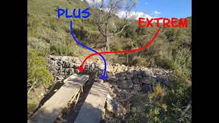
Variante DH en la senda original con curva peraltada, tramos muy verticales y contraperaltados y un drop no obligatorio.

Tags

Local Trail Association

Recent Activity on Trail

Past Week
  • 0 rides
  •  
6 Months
  • 1 rides
  • 37 miles avg distance
All
  • 11 rides
  • Last: Sep 26, 2026
update trails status or condition

Jaimito Extrem Trail Reports

Status:
on Jun 1, 2025
Ideal
Avg: 3.98 (1 votes)
Your vote: 0

view (23)
close
      Directions to jaimito-extrem trailhead (40.263620, 0.100920)

      Photos

      No photos have been added for Jaimito Extrem yet, add a photo.

      Videos

      1 more »
      Jaimito Extrem                                ...
      mtb
      4:01 | 125 | May 26, 2022 , Vilanova D'Alcolea
      4.0 ★★★★★
      1 Ratings
      5 ★
      4 ★ 100%
      3 ★
      2 ★
      1 ★

      1 Review & Comments

      juanx
      Ya no es tan chungo como fue, dos curvas finas con pendiente acusada

      We hope you've been enjoying Trailforks!

      Create a FREE account to view all trail reviews and much more.

      • By architrepaTF Pro TFSPAIN & contributors
      • #526613 - 412 views

      Frequently Asked Questions

      ▼ Where is Jaimito Extrem located?
      Jaimito Extrem is located in La Plana Alta, Vilanova D'Alcolea, Spain. It is part of the La Plana Alta trail network. The trailhead is located at coordinates 40.26362, 0.10092.
      ▼ How hard is Jaimito Extrem?
      Jaimito Extrem is rated as Black difficulty. The physical rating is Hard. The average grade is 14.3%. The climb difficulty is rated Double Black Diamond.
      ▼ What is the elevation gain for Jaimito Extrem?
      The trail has 125 ft of elevation descent. The elevation ranges from 820 ft to 945 ft.
      ▼ Is Jaimito Extrem a point to point trail?
      Yes, Jaimito Extrem is a point to point trail. The direction is Downhill Only. The trail type is singletrack.
      ▼ How long is Jaimito Extrem?
      Jaimito Extrem is 869 ft long. The trail type is singletrack.
      ▼ Are dogs allowed on Jaimito Extrem?
      Yes, dogs are allowed on Jaimito Extrem. Please keep dogs on a leash where required and clean up after them.
      ▼ How long does it take to ride Jaimito Extrem?
      Based on recorded activities, it takes an average of 2 minutes to ride Jaimito Extrem. The trail is 869 ft long. Actual times will vary based on fitness level, conditions, and pace. View recent activity logs for more details.
      ▼ How busy is Jaimito Extrem?
      Jaimito Extrem is a very popular trail. There have been 23 recorded activities on this trail. The trail has received 23 check-ins. View recent activity on this trail.

      Hit the Trail

      Open in App

      Get this trail on your phone instantly.

      open trail in app

      Download Trail

      Save to wishlist, Garmin & download.
      save the trail

      Find Related Routes

      Find routes and users activities that include this trail.
      find routes for this trail

      You must enter a description before submitting.