


more stats
2.2 miles
Distance
609 ft
Climb
-1,047 ft
Descent
00:16:24
Avg time
-438 ft
Altitude change
238 ft
Altitude min
714 ft
Altitude max
676 ft
Altitude start
240 ft
Altitude end
-3.7%
Grade
-45.9%
Grade max
59.6%
Grade min
4,170 ft
Distance climb
1 mile
Distance down
1,306 ft
Distance flat
00:16:24
Avg time

Jaws Details

  • Activities
    • Mountain Bike
    • E-Bike
    • Winter Fat Bike
  • Riding Area
  • Difficulty Rating
  • Voted Difficulty
    Blue (2 votes)
  • Local Popularity
    75 in Mountain Biking heatmap [+]
    • 75 in E-Biking
    • 5 in Winter Fat Biking
  • Global Ranking
    #39863 in Mountain Biking [+]
    • #23393 in E-Biking
    • #3013 in Winter Fat Biking
  • National Ranking
    #876 in Mountain Biking · New Zealand [+]
    • #502 in E-Biking
    • #8 in Winter Fat Biking
  • Trail Type
    Singletrack
  • Bike Type
    DH, AM, XC, Fat
  • Physical Rating
    Moderate
  • eBike Allowed
    Yes up to Class 1
  • TTFs on Trail
    Berm, Drop, Jump

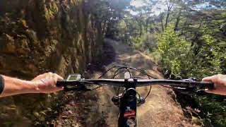
Probably the best trail in the park, could be described as a good Enduro trail, as there is a bit of peddling and a few uphill sections.

Small jumps, double jumps and tabletops. you can roll most of it easily but if you want to go for it you could get big air and it easily becomes a black diamond.

Beware though, side of track drops of in places so if you get it wrong it's gonna hurt - but the ambulance and chopper are well aware of the track location....

Access Info

From Ziggy Hub head up Ziggy and then Corkscrew

Tags
BermsDropsJumps

Local Trail Association

Recent Activity on Trail

Past Week
  • 4 rides
  • 14 miles average
6 Months
  • 17 rides
  • 10 miles avg distance
All
  • 423 rides
  • Last: Nov 16, 2026
c1c2c3c4
January
February
March
April
May
June
July
August
September
October
November
December
update trails status or condition

Jaws Trail Reports

statusdatedescription
Oct 17, 2026 @ 11:39am (Pacific/Auckland)
Oct 16, 2026
Jun 7, 2026 @ 11:37am (Pacific/Auckland)
Jun 6, 2026
two people, ten minutes with shovels will clear this
Apr 23, 2026 @ 5:46pm (Pacific/Auckland)
Apr 22, 2026
Tracks cut through the slips holding well
Feb 16, 2026 @ 1:02pm (Pacific/Auckland)
Feb 15, 2026
Large tree down across trail, blocking trail at around 136m elevation.
Jan 6, 2026 @ 4:38pm (Pacific/Auckland)
Jan 5, 2026
more »
Status:
on Oct 17, 2026
Ideal
Avg: 4.09 (29 votes)
Your vote: 0

view (3,024)
close
      Directions to jaws-45071 trailhead (-41.042110, 172.991940)

      Photos

      9 more »
      mtb
      410 |
      Mar 3, 2019 @ 11:26pm
      Mar 3, 2019
      mtb
      595 |
      Jul 3, 2016 @ 11:19pm
      Jul 3, 2016
      mtb
      80 |
      Dec 26, 2024 @ 7:49am
      Dec 26, 2024
      mtb
      426 |
      Oct 5, 2019 @ 7:59pm
      Oct 5, 2019

      Videos

      7 more »
      youtuber Jaws @ Kaiteriteri MTB Park.
      mtb
      10:36 | 563 | May 15, 2023 , Motueka
      Kaiteriteri - Jaws
      mtb
      12:17 | 209 | Jan 21, 2023 , Motueka
      Jaws - Full track -  Raw
      mtb
      11:13 | 623 | Jun 25, 2020 , Motueka
      MTB Trail Jaws - Complete - Jan 2019
      mtb
      12:57 | 551 | Feb 4, 2019 , Motueka
      4.1 ★★★★★
      29 Ratings
      5 ★ 55%
      4 ★ 17%
      3 ★ 14%
      2 ★ 10%
      1 ★ 3%

      9 Reviews & Comments

      leefluff leefluff
      Has taken a pounding in terms of slips over the last 3 years, but someone is working hard to keep this open.

      Honestly so good that you get to the bottom and wistfully look up at ziggy and consider another climb.

      Honestly the track just goes on for EVER it’s such a fun rollercoaster
      urban-broccoli urban-broccoli
      This is a fantastic trail. Nothing too tricky, but certainly not boring
      samspaven
      Awesome fun trail, good condition right now. All grade 3, could be 4 in places if you try send it. Probably not black diamond/ G5, unless you have a rocket up your arse. Not sure about what the write up suggests, probably don’t send it expecting the medics to come wipe your arse, it’s remote, patchy signal, and you’ll be waiting a very long time for Fentanyl if you snap anything.

      We hope you've been enjoying Trailforks!

      Create a FREE account to view all trail reviews and much more.

      • By epicrob & contributors
      • #45071 - 6,090 views

      Frequently Asked Questions

      ▼ Where is Jaws located?
      Jaws is located in Kaiteriteri MTB Park, Motueka, New Zealand. It is part of the Kaiteriteri MTB Park trail network. The trailhead is located at coordinates -41.04211, 172.99194.
      ▼ How hard is Jaws?
      Jaws is rated as Advanced difficulty. The physical rating is Moderate. The average grade is 3.7%.
      ▼ What is the elevation gain for Jaws?
      Jaws has 609 ft of elevation gain. The trail has 1,047 ft of elevation descent. The elevation ranges from 238 ft to 714 ft.
      ▼ How long is Jaws?
      Jaws is 2.2 miles long. The trail type is singletrack.
      ▼ Are dogs allowed on Jaws?
      There is no information about dogs being allowed on Jaws. Check with local trail managers or the trail page for the latest access rules.
      ▼ When is the best time of year to ride Jaws?
      Based on activity log data, the most popular months to ride Jaws are:
      • January (54 activities)
      • December (29 activities)
      • February (21 activities)
      Check the reports page for current trail conditions.
      ▼ How do I access Jaws? Where is the closest parking trailhead?
      The closest parking and trailhead locations to Jaws are: View all parking locations in the area.
      ▼ How long does it take to ride Jaws?
      Based on recorded activities, it takes an average of 16 minutes to ride Jaws. The trail is 2.2 miles long. Actual times will vary based on fitness level, conditions, and pace. View recent activity logs for more details.
      ▼ How busy is Jaws?
      Jaws is a very popular trail. There have been 3,086 recorded activities on this trail. The trail has received 3,024 check-ins. View recent activity on this trail.

      Hit the Trail

      Open in App

      Get this trail on your phone instantly.

      open trail in app

      Download Trail

      Save to wishlist, Garmin & download.
      save the trail

      Find Related Routes

      Find routes and users activities that include this trail.
      find routes for this trail

      You must enter a description before submitting.

