

more stats
1,512 ft
Distance
-174 ft
Descent
00:06:57
Avg time
-174 ft
Altitude change
3,041 ft
Altitude min
3,215 ft
Altitude max
3,215 ft
Altitude start
3,041 ft
Altitude end
-11.5%
Grade
-42.2%
Grade max
13 ft
Distance climb
1,457 ft
Distance down
43 ft
Distance flat
00:06:57
Avg time

Jumpgartner Trail Details

  • Activities
    • Mountain Bike
    • E-Bike
  • Riding Area
  • Ref Number
    T28
  • Difficulty Rating
  • Local Popularity
    65 in Mountain Biking heatmap [+]
    • 65 in E-Biking
  • Global Ranking
    #19252 in Mountain Biking [+]
    • #40865 in E-Biking
  • National Ranking
    #206 in Mountain Biking · Austria [+]
    • #282 in E-Biking
  • Trail Type
    Singletrack
  • Direction
    Downhill Only
    Popular Direction Shown
  • Climb Difficulty
    Blue
  • Physical Rating
    Moderate
  • Trail Visibility
    Always easy to follow
  • eBike Allowed
  • TTFs on Trail
    Berm, Jump
  • Year Opened
    2023
  • Land Owner
    lake.bike

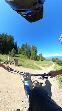
The Jumpgartner Trail is a jumpline in the Trailcenterfaakersee with tables, shark fins, step-ups and much more. Everyone who loves air-time and wants to try new tricks will feel comfortable on this jumpline.

Access Info

From Faak am See always follow the Signs "Transfer" and the number T28.

Tags
BermsJumps

Recent Activity on Trail

Past Week
  • 1 rides
  • 16 miles average
6 Months
  • 21 rides
  • 16 miles avg distance
All
  • 63 rides
  • Last: Nov 9, 2026
c1c2c3c4
January
February
March
April
May
June
July
August
September
October
November
December
update trails status or condition

Jumpgartner Trail Trail Reports

statusdatedescription
Nov 15, 2026 @ 7:51pm (Europe/Vienna)
2 hours
reporter Season is over, see you 2027!
Aug 1, 2026 @ 8:31pm (Europe/Vienna)
Aug 1, 2026
good condition, warning the first table top is a bit long, then the second is super short
Mar 31, 2026 @ 7:38pm (Europe/Vienna)
Mar 31, 2026
reporter Season opening 01.04.2026
Nov 9, 2025 @ 6:42pm (Europe/Vienna)
Nov 9, 2025
reporter Season ist over. See you 2026.
Apr 22, 2025 @ 10:48pm
Apr 22, 2025
Achtung: Ab 01.05.2025 sind die Trails kostenpflichtig. Ein Trailticket muss gekauft werden. Attention: From 01.05.2025 the trails are subject to...
more »
Status:
on Nov 15, 2026
Avg: 3.99 (5 votes)
Your vote: 0

view (232)
close
      Directions to jumpgartner-trail trailhead (46.535900, 13.903540)

      Photos

      31 more »
      mtb
      220 |
      May 26, 2026 @ 11:31pm
      May 26, 2026
      mtb
      409 |
      May 26, 2026 @ 11:31pm
      May 26, 2026
      mtb
      157 |
      Nov 4, 2025 @ 1:31am
      Nov 4, 2025
      mtb
      155 |
      Nov 4, 2025 @ 1:31am
      Nov 4, 2025

      Videos

      1 more »
      jumpgartner
      mtb
      0:59 | 99 | Sep 17, 2023 , Villach
      4.0 ★★★★★
      5 Ratings
      5 ★ 40%
      4 ★ 20%
      3 ★ 40%
      2 ★
      1 ★

      1 Review & Comments

      ktnkgb ktnkgb
      Meh... Feels like another wasted opportunity. The first table is bigger than the next one. Some weird "flow"/rhythm. You can still have fun for a couple of laps... but...meh

      We hope you've been enjoying Trailforks!

      Create a FREE account to view all trail reviews and much more.

      • By lakebiketrailsTF Pro lakebike & contributors
      • #667419 - 906 views

      Frequently Asked Questions

      ▼ Where is Jumpgartner Trail located?
      Jumpgartner Trail is located in Trailcenter Faaker See, Villach, Austria. It is part of the Trailcenter Faaker See trail network. The trailhead is located at coordinates 46.5359, 13.90354.
      ▼ How hard is Jumpgartner Trail?
      Jumpgartner Trail is rated as Red difficulty. The physical rating is Moderate. The average grade is 11.5%. The climb difficulty is rated Blue.
      ▼ What is the elevation gain for Jumpgartner Trail?
      The trail has 174 ft of elevation descent. The elevation ranges from 3,041 ft to 3,215 ft.
      ▼ Is Jumpgartner Trail a point to point trail?
      Yes, Jumpgartner Trail is a point to point trail. The direction is Downhill Only. The trail type is singletrack.
      ▼ How long is Jumpgartner Trail?
      Jumpgartner Trail is 1,512 ft long. The trail type is singletrack.
      ▼ Are dogs allowed on Jumpgartner Trail?
      There is no information about dogs being allowed on Jumpgartner Trail. Check with local trail managers or the trail page for the latest access rules.
      ▼ When is the best time of year to ride Jumpgartner Trail?
      Based on activity log data, the most popular months to ride Jumpgartner Trail are:
      • August (17 activities)
      • April (7 activities)
      • October (7 activities)
      Check the reports page for current trail conditions.
      ▼ How do I access Jumpgartner Trail? Where is the closest parking trailhead?
      The closest parking and trailhead locations to Jumpgartner Trail are: View all parking locations in the area.
      ▼ How long does it take to ride Jumpgartner Trail?
      Based on recorded activities, it takes an average of 7 minutes to ride Jumpgartner Trail. The trail is 1,512 ft long. Actual times will vary based on fitness level, conditions, and pace. View recent activity logs for more details.
      ▼ How busy is Jumpgartner Trail?
      Jumpgartner Trail is a moderately popular trail. There have been 184 recorded activities on this trail. The trail has received 232 check-ins. View recent activity on this trail.

      Hit the Trail

      Open in App

      Get this trail on your phone instantly.

      open trail in app

      Download Trail

      Save to wishlist, Garmin & download.
      save the trail

      Find Related Routes

      Find routes and users activities that include this trail.
      find routes for this trail

      You must enter a description before submitting.

