more stats
4,780 ft
Distance
154 ft
Climb
-186 ft
Descent
00:30:46
Avg time
-32 ft
Altitude change
966 ft
Altitude min
1,073 ft
Altitude max
998 ft
Altitude start
968 ft
Altitude end
-0.7%
Grade
-28.3%
Grade max
21%
Grade min
1,729 ft
Distance climb
2,172 ft
Distance down
879 ft
Distance flat
00:30:46
Avg time

Lumpy Bumpy Details

  • Activities
    • Mountain Bike
    • Hike
    • Trail Running
  • Riding Area
    Allamuchy Mountain State Park
    Byram Township, New Jersey
  • Difficulty Rating
  • Voted Difficulty
    Black Diamond (3 votes)
  • Local Popularity
    90 in Mountain Biking [+]
    • 5 in Trail Running
    • 5 in Hiking
  • Global Ranking
    #39960 in Mountain Biking [+]
    • #90855 in Trail Running
    • #68755 in Hiking
  • Hiking SAC Scale
    T2 Mountain Hiking
  • Trail Type
    Singletrack
  • Bike Type
    DH, AM, XC
  • Direction
    Downhill Primary
    Popular Direction Shown
  • Climb Difficulty
    Black Diamond
  • Physical Rating
    Hard
  • Trail Visibility
    Sometimes hard to follow
  • Dogs Allowed
    Yes
  • eBike Allowed
  • TTFs on Trail
    Rock Face, Rock Garden
  • Land Owner
    NJ DEP

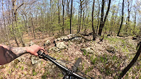
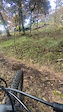
Steep terrain with lots of rock to climb and roll. The top is all exposed rock and features rollers, ramps, and rock spine riding. Taken in the usual direction, the end of the trail is all challenging rock gardens. Make-able, but difficult. This one will keep you on your toes and coming back for more.

Local Trail Association
Traditionally Indigenous Territory

Recent Activity on Trail

Past Week
  • 0 rides
  •  
6 Months
  • 8 rides
  • 9 miles avg distance
All
  • 221 rides
  • Last: May 31, 2026
c1c2c3c4
January
February
March
April
May
June
July
August
September
October
November
December
Status:
on Apr 13, 2026
Dry
Avg: 4.28 (16 votes)
Your vote: 0

view (831)
close
3D
Trail Conditions
  • Unknown
  • Snow Groomed
  • Snow Packed
  • Snow Covered
  • Snow Cover Partial
  • Freeze/thaw Cycle
  • Icy
  • Prevalent Mud
  • Wet
  • Variable
  • Ideal
  • Dry
  • Very Dry
Trail Flow (Ridden Direction)
Trailforks scans users ridelogs to determine the most popular direction each trail is ridden. A good flowing trail network will have most trails flowing in a single direction according to their intension.
The colour categories are based on what percentage of riders are riding a trail in its intended direction.
  • > 96%
  • > 90%
  • > 80%
  • > 70%
  • > 50%
  • < 50%
  • bi-directional trail
  • no data
Trail Last Ridden
Trailforks scans ridelogs to determine the last time a trail was ridden.
  • < 2 days
  • < 1 week
  • < 2 weeks
  • < 1 month
  • < 6 months
  • > 6 months
Trail Ridden Direction
The intended direction a trail should be ridden.
  • Downhill Only
  • Downhill Primary
  • Both Directions
  • Uphill Primary
  • Uphill Only
  • One Direction
Contribute Details
Colors indicate trail is missing specified detail.
  • Description
  • Photos
  • Description & Photos
  • Videos
Trail Popularity ?
Trailforks scans ridelogs to determine which trails are ridden the most in the last 9 months. Trails are compared with nearby trails in the same city region with a possible 25 colour shades. Think of this as a heatmap, more rides = more kinetic energy = warmer colors.
  • most popular
  • popular
  • less popular
  • not popular
ATV/ORV/OHV Filter
Max Vehicle Width
inches
US Cell Coverage
Legend
cell carrier legend

Radar Time
Activity Recordings
Trailforks uses anonymized public activity data. ?
Activity Recordings
Trailforks uses anonymized public activity data. ?
Personal Heatmap
Activity Types
all / none
Options
2
Date range month
Winter Trails
Warning A routing network for winter maps does not exist. Selecting trails using the winter trails layer has been disabled.
Missing Trails
Most Popular
Least Popular
Trails are colored based on popularity. The more popular a trail is, the more red. Less popular trails trend towards green.
Jump Magnitude Heatmap
Heatmap of where riders jump on trails. Zoom in to see individual jumps, click circles to view jump details.
BC Backroad Status

Service Road Atlas is a free to use, community-driven service for viewing and creating reports on the numerous back-country service roads around B.C. and Alberta.

map legend
Slope Aspect
Direction the slope faces
Flat N NE E SE S SW W NW
Trails Deemphasized
Trails are shown in grey.
disable
Only show trails with no bike usage.
Enable
Suggested Layers
Based on selected activity type

    Save the current map location and zoom level as your default home location whenever this page is loaded.

    Save
        Directions to lumpy-bumpy trailhead (40.944170, -74.759920)

        Photos

        13 more »
        296 |
        Aug 25, 2020 @ 4:41am
        Aug 25, 2020
        233 |
        Aug 25, 2020 @ 4:41am
        Aug 25, 2020
        303 |
        Aug 25, 2020 @ 4:33am
        Aug 25, 2020
        304 |
        Aug 25, 2020 @ 4:26am
        Aug 25, 2020

        Videos

        5 more »
        Wavin Willy & Lumpy Bumpy II
        3:00 | 16 | Apr 22, 2026 , Byram Township
        Wavin Willy & Lumpy Bumpy
        3:00 | 21 | Apr 21, 2026 , Byram Township
        Trying to Rip the Gnar on Lumpy Bumpy
        0:57 | 235 | Aug 24, 2022 , Byram Township
        Lumpy Bumpy
        3:00 | 244 | Apr 8, 2022 , Byram Township

        Routes with this trail

        9 miles 1,518 ft 8 Loop
        Starting at Tranquility Lot, hits and Roly Poly
        14 miles 1,807 ft 11 Out & Back
        Almost all of the good stuff
        15 miles 1,935 ft 11
        Gnar enabled! Learn more about how JORBA builds and maintains the trails you ride at jorba.org.

        4 Reviews & Comments


        We hope you've been enjoying Trailforks!

        Create a FREE account to view trail comments and much more.

        • By iridefatbikesTF Pro & contributors
        • #26721 - 5,069 views

        Frequently Asked Questions About Lumpy Bumpy

        Where is Lumpy Bumpy located?
        Lumpy Bumpy is located in Allamuchy Mountain State Park, Byram Township, New Jersey, United States. It is part of the Allamuchy Mountain State Park trail network. The trailhead is located at coordinates 40.94417, -74.75992.
        How hard is Lumpy Bumpy?
        Lumpy Bumpy is rated as Black Diamond difficulty. The physical rating is Hard. The average grade is 0.7%. The climb difficulty is rated Black Diamond.
        What is the elevation gain for Lumpy Bumpy?
        Lumpy Bumpy has 154 ft of elevation gain. The trail has 186 ft of elevation descent. The elevation ranges from 966 ft to 1,073 ft.
        Is Lumpy Bumpy a point to point trail?
        Lumpy Bumpy is not a point to point trail. The direction is Downhill Primary. The trail type is singletrack.

        Hit the Trail

        Open in App

        Get this trail on your phone instantly.
        open trail in app

        Download Trail

        Save to wishlist, Garmin & download.
        save the trail

        Find Related Routes

        Find routes and users activities that include this trail.
        find routes for this trail

        You must enter a description before submitting.