more stats
644 ft
Distance
7 ft
Climb
-31 ft
Descent
00:00:41
Avg time
-24 ft
Altitude change
192 ft
Altitude min
217 ft
Altitude max
217 ft
Altitude start
193 ft
Altitude end
-3.728%
Grade
-13.28%
Grade max
10.462%
Grade min
76 ft
Distance climb
257 ft
Distance down
302 ft
Distance flat
00:00:41
Avg time

QFB Details

  • Activities
    • Mountain Bike
  • Riding Area
    Kincaid Park
    Anchorage, Alaska
  • Difficulty Rating
  • Local Popularity
    95 in Mountain Biking
  • Global Ranking
    #4153 in Mountain Biking
  • Trail Type
    Singletrack
  • Direction
    Downhill Only
  • Season
    MAY - OCT
  • Dogs Allowed
    Yes
  • Year Opened
    2014

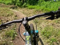
The shortest trail in the system, it is a fun little flowy downhill after Lee's train. It is downhill ONLY, the majority of the trail are tight and high berms following a small drainage. This is also one of the last trails to dry out in the spring.

Access Info

From the bottom of Lee's Train at the intersection of C$ the entrance to QFB is close. Just bike down C$ for a little ways and the trail will be on your left opposite a short climb (on C$).

Local Trail Association
Traditionally Indigenous Territory

Recent Activity on Trail

Past Week
  • 7 rides
  • 7 miles average
6 Months
  • 112 rides
  • 10 miles avg distance
All
  • 1,612 rides
  • Last: Jun 24, 2026
c1c2c3c4
January
February
March
April
May
June
July
August
September
October
November
December
Status:
on Jun 19, 2025
Wet
Avg: 4.33 (6 votes)
Your vote: 0

view (12,037)
close
3D
Trail Conditions
  • Unknown
  • Snow Groomed
  • Snow Packed
  • Snow Covered
  • Snow Cover Partial
  • Freeze/thaw Cycle
  • Icy
  • Prevalent Mud
  • Wet
  • Variable
  • Ideal
  • Dry
  • Very Dry
Trail Flow (Ridden Direction)
Trailforks scans users ridelogs to determine the most popular direction each trail is ridden. A good flowing trail network will have most trails flowing in a single direction according to their intension.
The colour categories are based on what percentage of riders are riding a trail in its intended direction.
  • > 96%
  • > 90%
  • > 80%
  • > 70%
  • > 50%
  • < 50%
  • bi-directional trail
  • no data
Trail Last Ridden
Trailforks scans ridelogs to determine the last time a trail was ridden.
  • < 2 days
  • < 1 week
  • < 2 weeks
  • < 1 month
  • < 6 months
  • > 6 months
Trail Ridden Direction
The intended direction a trail should be ridden.
  • Downhill Only
  • Downhill Primary
  • Both Directions
  • Uphill Primary
  • Uphill Only
  • One Direction
Contribute Details
Colors indicate trail is missing specified detail.
  • Description
  • Photos
  • Description & Photos
  • Videos
Trail Popularity ?
Trailforks scans ridelogs to determine which trails are ridden the most in the last 9 months. Trails are compared with nearby trails in the same city region with a possible 25 colour shades. Think of this as a heatmap, more rides = more kinetic energy = warmer colors.
  • most popular
  • popular
  • less popular
  • not popular
ATV/ORV/OHV Filter
Max Vehicle Width
inches
US Cell Coverage
Legend
cell carrier legend

Radar Time
Activity Recordings
Trailforks uses anonymized public activity data. ?
Activity Recordings
Trailforks uses anonymized public activity data. ?
Personal Heatmap
Activity Types
all / none
Options
2
Date range month
Winter Trails
Warning A routing network for winter maps does not exist. Selecting trails using the winter trails layer has been disabled.
Missing Trails
Most Popular
Least Popular
Trails are colored based on popularity. The more popular a trail is, the more red. Less popular trails trend towards green.
Jump Magnitude Heatmap
Heatmap of where riders jump on trails. Zoom in to see individual jumps, click circles to view jump details.
BC Backroad Status

Service Road Atlas is a free to use, community-driven service for viewing and creating reports on the numerous back-country service roads around B.C. and Alberta.

map legend
Slope Aspect
Direction the slope faces
Flat N NE E SE S SW W NW
Trails Deemphasized
Trails are shown in grey.
disable
Only show trails with no bike usage.
Enable
Suggested Layers
Based on selected activity type

    Save the current map location and zoom level as your default home location whenever this page is loaded.

    Save
        Directions to qfb trailhead (61.147710, -150.037070)

        Photos

        2 more »
        67 |
        Jun 14, 2023 @ 7:03pm
        Jun 14, 2023
        94 |
        Apr 26, 2020 @ 4:39pm
        Apr 26, 2020

        Videos

        1 more »
        Kincaid Park - 'QFB'
        32 | Jun 20, 2025 , Anchorage

        Trail Lists

        Routes with this trail

        11 miles 1,049 ft 9
        A route featuring most of the South Kincaid Trails, except for half of Boling alley.
        36 miles 3,253 ft 23 Loop
        COURSE DESCRIPTION Racers should always follow the flags to their right. There are multiple areas where...
        3.5 13 miles 1,233 ft 5 Loop Race
        This is the Hammerman Bike Course for years when the race falls on an odd-numbered day. This is due to...

        Reviews / Comments

        No reviews yet, be the first to write a review or ask a question.
        Use trail reports to comment on trail conditions.


        We hope you've been enjoying Trailforks!

        Create a FREE account to view trail comments and much more.

        Frequently Asked Questions About QFB

        Where is QFB located?
        QFB is located in Kincaid Park, Anchorage, Alaska, United States. It is part of the Kincaid Park trail network. The trailhead is located at coordinates 61.14771, -150.03707.
        How hard is QFB?
        QFB is rated as Blue difficulty. The average grade is 3.728%.
        What is the elevation gain for QFB?
        QFB has 7 ft of elevation gain. The trail has 31 ft of elevation descent. The elevation ranges from 192 ft to 217 ft.
        Is QFB a point to point trail?
        Yes, QFB is a point to point trail. The direction is Downhill Only. The trail type is singletrack.

        Hit the Trail

        Open in App

        Get this trail on your phone instantly.
        open trail in app

        Download Trail

        Save to wishlist, Garmin & download.
        save the trail

        Find Related Routes

        Find routes and users activities that include this trail.
        find routes for this trail

        You must enter a description before submitting.