more stats
1,975 ft
Distance
-186 ft
Descent
1,513 ft
High Point
-185 ft
Altitude change
1,327 ft
Altitude min
1,513 ft
Altitude start
1,329 ft
Altitude end
-9.4%
Grade
-34.9%
Grade max
0.7%
Grade min
108 ft
Distance climb
1,772 ft
Distance down
98 ft
Distance flat

Raspberry Line Details

  • Activities
    • Mountain Bike
    • E-Bike
  • Riding Area
  • Difficulty Rating
  • Local Popularity
    90 in Mountain Biking [+]
    • 90 in E-Biking
  • Global Ranking
    #6446 in Mountain Biking [+]
    • #26348 in E-Biking
  • Trail Type
    Singletrack
  • Bike Type
    DH, AM, XC
  • Direction
    Downhill Only
    Popular Direction Shown
  • Trail Visibility
    Always easy to follow
  • Season
    March-October
  • Family Friendly
    Yes
  • Dogs Allowed
    Yes
  • eBike Allowed
    Yes up to Class 1
  • TTFs on Trail
    Berm, Jump
  • Year Opened
    2024

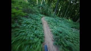
Die für Sommer 2024 neue Raspberry-Line ist 750 Meter lang mit einer Schwierigkeit von leicht-mittel. Sie enthält einige Steilkurven und wenige Sprünge, die alle überrollt oder umfahren werden können. Sie verläuft von oben bis zum neuen Knotenpunkt wo Auffahrt und Fun Line zusammenkommen. Achtung, bei der Einmündung auf die Fun-Line muss Vorrang gegeben werden Vom Knotenpunkt können die untere Hälfte der Fun- oder Flow-Lines bzw. die neue Blackberry-Line bis zum unteren Ende des Trailparks befahren werden. Alternativ kann die Forststraße wieder hinauf zum Start gefahren werden.

Local Trail Association

Recent Activity on Trail

Past Week
  • 1 rides
  • 27 miles average
6 Months
  • 19 rides
  • 24 miles avg distance
All
  • 53 rides
  • Last: Jun 17, 2026
c1c2c3c4
January
February
March
April
May
June
July
August
September
October
November
December
update trails status or condition

Raspberry Line Trail Reports

statusdatedescription
Mar 3, 2026 @ 10:08am (Europe/Vienna)
Mar 3, 2026
Mit 1. März endet die Wintersperre und alle Trails im Wienerwald sind wieder eröffnet. Viel Spaß in der neuen Saison und fahrt vorsichtig.
Nov 4, 2025 @ 10:55am (Europe/Vienna)
Nov 4, 2025
Mit 1. November endet die vertragliche Erlaubnis für Mountainbiken im Wald und alle Strecken sind bis 1.3.2025 aufgrund des Forstgesetzes gesperrt.
Oct 19, 2025 @ 1:05pm (Europe/Vienna)
Oct 19, 2025
Oct 11, 2025 @ 8:18am (Europe/Vienna)
Oct 10, 2025
Apr 27, 2025 @ 10:02am
Apr 27, 2025
more »
Status:
on Mar 3, 2026
Ideal
Avg: 4.24 (2 votes)
Your vote: 0

view (389)
close
3D
Trail Conditions
  • Unknown
  • Snow Groomed
  • Snow Packed
  • Snow Covered
  • Snow Cover Partial
  • Freeze/thaw Cycle
  • Icy
  • Prevalent Mud
  • Wet
  • Variable
  • Ideal
  • Dry
  • Very Dry
Trail Flow (Ridden Direction)
Trailforks scans users ridelogs to determine the most popular direction each trail is ridden. A good flowing trail network will have most trails flowing in a single direction according to their intension.
The colour categories are based on what percentage of riders are riding a trail in its intended direction.
  • > 96%
  • > 90%
  • > 80%
  • > 70%
  • > 50%
  • < 50%
  • bi-directional trail
  • no data
Trail Last Ridden
Trailforks scans ridelogs to determine the last time a trail was ridden.
  • < 2 days
  • < 1 week
  • < 2 weeks
  • < 1 month
  • < 6 months
  • > 6 months
Trail Ridden Direction
The intended direction a trail should be ridden.
  • Downhill Only
  • Downhill Primary
  • Both Directions
  • Uphill Primary
  • Uphill Only
  • One Direction
Contribute Details
Colors indicate trail is missing specified detail.
  • Description
  • Photos
  • Description & Photos
  • Videos
Trail Popularity ?
Trailforks scans ridelogs to determine which trails are ridden the most in the last 9 months. Trails are compared with nearby trails in the same city region with a possible 25 colour shades. Think of this as a heatmap, more rides = more kinetic energy = warmer colors.
  • most popular
  • popular
  • less popular
  • not popular
ATV/ORV/OHV Filter
Max Vehicle Width
inches
US Cell Coverage
Legend
cell carrier legend

Radar Time
Activity Recordings
Trailforks uses anonymized public activity data. ?
Activity Recordings
Trailforks uses anonymized public activity data. ?
Personal Heatmap
Activity Types
all / none
Options
2
Date range month
Winter Trails
Warning A routing network for winter maps does not exist. Selecting trails using the winter trails layer has been disabled.
Missing Trails
Most Popular
Least Popular
Trails are colored based on popularity. The more popular a trail is, the more red. Less popular trails trend towards green.
Jump Magnitude Heatmap
Heatmap of where riders jump on trails. Zoom in to see individual jumps, click circles to view jump details.
BC Backroad Status

Service Road Atlas is a free to use, community-driven service for viewing and creating reports on the numerous back-country service roads around B.C. and Alberta.

map legend
Slope Aspect
Direction the slope faces
Flat N NE E SE S SW W NW
Trails Deemphasized
Trails are shown in grey.
disable
Only show trails with no bike usage.
Enable
Suggested Layers
Based on selected activity type

    Save the current map location and zoom level as your default home location whenever this page is loaded.

    Save
        Directions to raspberry-line trailhead (48.273240, 16.246570)

        Photos

        5 more »
        34 |
        Jul 14, 2024 @ 12:44am
        Jul 14, 2024
        36 |
        Jul 14, 2024 @ 12:42am
        Jul 14, 2024
        32 |
        Jul 14, 2024 @ 12:40am
        Jul 14, 2024
        42 |
        Jul 14, 2024 @ 12:40am
        Jul 14, 2024

        Videos

        1 more »
        Raspberry und Blackberry Line
        2:50 | 9 | May 7, 2026 , Vienna

        3 Reviews & Comments


        We hope you've been enjoying Trailforks!

        Create a FREE account to view trail comments and much more.

        • By m0le & contributors
        • #771786 - 349 views

        Frequently Asked Questions About Raspberry Line

        Where is Raspberry Line located?
        Raspberry Line is located in Trail-Area Wien Nord, Vienna, Austria. It is part of the Trail-Area Wien Nord trail network. The trailhead is located at coordinates 48.27324, 16.24657.
        How hard is Raspberry Line?
        Raspberry Line is rated as Red difficulty. The average grade is 9.4%.
        What is the elevation gain for Raspberry Line?
        The trail has 186 ft of elevation descent. The elevation ranges from 1,327 ft to 1,513 ft.
        Is Raspberry Line a point to point trail?
        Yes, Raspberry Line is a point to point trail. The direction is Downhill Only. The trail type is singletrack.

        Hit the Trail

        Open in App

        Get this trail on your phone instantly.
        open trail in app

        Download Trail

        Save to wishlist, Garmin & download.
        save the trail

        Find Related Routes

        Find routes and users activities that include this trail.
        find routes for this trail

        You must enter a description before submitting.