Rundle Riverside Details
-
Activities
- Mountain Bike
- Hike
- Trail Running
-
Riding AreaBanff
, Alberta -
Difficulty Rating
-
Trail TypeSingletrack
-
DirectionBoth Directions
-
Physical RatingModerate
-
SeasonLate May - Late Oct
-
eBike Allowed
-
Global Ranking
-
Local Popularity45 in Mountain Biking [+]
- 80 in Trail Running
- 5 in Hiking
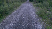
Masochists need only apply. Although not physically demanding, the trail does take it's toll on the body via soul-crushing roots that cover the trail from beginning to end. There is some fun to be had on a few short downhill sections but you'd be hard pressed to find anyone who says these sections balance out the rooty grind otherwise.
Can be ridden either way - net uphill going eastbound with a short, tough climb at the finish as you get to the park boundary and Canmore Nordic Centre. Multiple sections regularly stay swampy well through spring and into early summer as the trail is completely shaded by Mt. Rundle.
Usually combined with the Goat Creek trail to make a big loop (~50km) of Mt. Rundle. Otherwise, it's good to ride once a year to remind you how smooth the other trails in the area are ![]() (except Upper Stoney Squaw).
(except Upper Stoney Squaw).
Local Trail Association
-

-
Please consider joining or donating to the local trail association to supportdonate to earn trail karma!
trail development & maintenance.
Traditionally Indigenous Territory
More Stats for Rundle Riverside mountain bike trail trail
-
Altitude change-24 ft
-
Altitude min4,427 ft
-
Altitude max4,632 ft
-
Altitude start4,632 ft
-
Altitude end4,606 ft
-
Grade-0.1%
-
Grade max-25%
-
Grade min17.9%
-
Distance climb2 miles
-
Distance down2 miles
-
Distance flat1 mile
-
Avg time00:59:53
-
Avg reverse time01:14:16
- view trail stats
-
Layers w
- Map Content
- More Layers
- Pro
- Pro
- Pro
- Pro
- Pro
- Pro
- Pro
- Pro
-
Upgrade to

- Unknown
- Snow Groomed
- Snow Packed
- Snow Covered
- Snow Cover Partial
- Freeze/thaw Cycle
- Icy
- Prevalent Mud
- Wet
- Variable
- Ideal
- Dry
- Very Dry
The colour categories are based on what percentage of riders are riding a trail in its intended direction.
- > 96%
- > 90%
- > 80%
- > 70%
- > 50%
- < 50%
- bi-directional trail
- no data
- < 2 days
- < 1 week
- < 2 weeks
- < 1 month
- < 6 months
- > 6 months
- Downhill Only
- Downhill Primary
- Both Directions
- Uphill Primary
- Uphill Only
- One Direction
- Description
- Photos
- Description & Photos
- Videos
- most popular
- popular
- less popular
- not popular

- mountain biking recent
- mountain biking (>6 month)
- hiking (1 year)
- moto (1 year)
- Downhill Ski
- Backcountry Ski
- Nordic Ski
- Snowmobile
Save the current map location and zoom level as your default home location whenever this page is loaded.
SaveRundle Riverside Trail Reports
Recent Ridelog Activity on Trail
- 0 rides
- 0 rides
- 347 rides
- Last: Aug 27, 2023
Photos
Routes with this trail
Trail Products
16 Reviews & Comments
We hope you've been enjoying Trailforks!
Create a FREE account to view trail comments and much more.
Videos
Nearby Trails
- Rundle (north) 1,736 ft
- Cold Shoulder 2,270 ft
- Grey Wolf 2 miles
- Wooded Bliss 2 miles
- Cougar 2 miles
- By canadaka
 Trailforks & contributors
 - #8590 - 16,219 views
- follow/subscribe
- login to download gpx or kml files.
You must enter a description before submitting.