more stats
2,953 ft
Distance
8 ft
Climb
-296 ft
Descent
00:03:05
Avg time
-288 ft
Altitude change
4,000 ft
Altitude min
4,290 ft
Altitude max
4,288 ft
Altitude start
3,999 ft
Altitude end
-9.8%
Grade
-25.7%
Grade max
12.1%
Grade min
105 ft
Distance climb
2,740 ft
Distance down
108 ft
Distance flat
00:03:05
Avg time

Sidecut Details

  • Activities
    • Mountain Bike
    • E-Bike
    • Hike
    • Trail Running
  • Riding Area
    Kimberley Nordic Center and Ski Hill
    Kimberley, British Columbia
  • Difficulty Rating
  • Local Popularity
    90 in Mountain Biking [+]
    • 75 in E-Biking
    • 60 in Trail Running
    • 55 in Hiking
  • Global Ranking
    #58842 in Mountain Biking [+]
    • #50160 in E-Biking
    • #99167 in Trail Running
    • #115171 in Hiking
  • Trail Type
    Singletrack
  • Bike Type
    AM, XC
  • Direction
    Downhill Only
  • Physical Rating
    Moderate
  • Dogs Allowed
    Yes
  • eBike Allowed

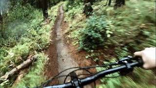
Sidecut Trail has been multiple times in passed Enduro races and riders will be quick to see why. This is an aptly named handbuilt side-cut bench with no switch backs. The second half of the trail is rougher and rockier while maintaining its side cut traversal pattern.

This trail is closed to uphill cycling and other uphill traffic is not recommended.

Local Trail Association
Traditionally Indigenous Territory

Recent Activity on Trail

Past Week
  • 3 rides
  • 11 miles average
6 Months
  • 36 rides
  • 9 miles avg distance
All
  • 504 rides
  • Last: Jun 7, 2026
c1c2c3c4
January
February
March
April
May
June
July
August
September
October
November
December
update trails status or condition

Sidecut Trail Reports

statusdatedescription
May 3, 2026 @ 7:58pm (America/Edmonton)
May 3, 2026
Apr 14, 2026 @ 1:41pm (America/Edmonton)
Apr 14, 2026
3 trees cleared/trail clear
Apr 13, 2026 @ 6:17pm (America/Edmonton)
Apr 13, 2026
3 trees down below boulder intersection. 3 to 8 inches. passable.
Oct 31, 2025 @ 2:42pm (America/Edmonton)
Oct 31, 2025
Trail clear
Jul 19, 2025 @ 12:16pm
Jul 19, 2025
Tree cleared/trail clear
more »
Status:
on May 3, 2026
Ideal
Avg: 3.91 (7 votes)
Your vote: 0

view (3,037)
close
3D
Trail Conditions
  • Unknown
  • Snow Groomed
  • Snow Packed
  • Snow Covered
  • Snow Cover Partial
  • Freeze/thaw Cycle
  • Icy
  • Prevalent Mud
  • Wet
  • Variable
  • Ideal
  • Dry
  • Very Dry
Trail Flow (Ridden Direction)
Trailforks scans users ridelogs to determine the most popular direction each trail is ridden. A good flowing trail network will have most trails flowing in a single direction according to their intension.
The colour categories are based on what percentage of riders are riding a trail in its intended direction.
  • > 96%
  • > 90%
  • > 80%
  • > 70%
  • > 50%
  • < 50%
  • bi-directional trail
  • no data
Trail Last Ridden
Trailforks scans ridelogs to determine the last time a trail was ridden.
  • < 2 days
  • < 1 week
  • < 2 weeks
  • < 1 month
  • < 6 months
  • > 6 months
Trail Ridden Direction
The intended direction a trail should be ridden.
  • Downhill Only
  • Downhill Primary
  • Both Directions
  • Uphill Primary
  • Uphill Only
  • One Direction
Contribute Details
Colors indicate trail is missing specified detail.
  • Description
  • Photos
  • Description & Photos
  • Videos
Trail Popularity ?
Trailforks scans ridelogs to determine which trails are ridden the most in the last 9 months. Trails are compared with nearby trails in the same city region with a possible 25 colour shades. Think of this as a heatmap, more rides = more kinetic energy = warmer colors.
  • most popular
  • popular
  • less popular
  • not popular
ATV/ORV/OHV Filter
Max Vehicle Width
inches
US Cell Coverage
Legend
cell carrier legend

Radar Time
Activity Recordings
Trailforks uses anonymized public activity data. ?
Activity Recordings
Trailforks uses anonymized public activity data. ?
Personal Heatmap
Activity Types
all / none
Options
2
Date range month
Winter Trails
Warning A routing network for winter maps does not exist. Selecting trails using the winter trails layer has been disabled.
Missing Trails
Most Popular
Least Popular
Trails are colored based on popularity. The more popular a trail is, the more red. Less popular trails trend towards green.
Jump Magnitude Heatmap
Heatmap of where riders jump on trails. Zoom in to see individual jumps, click circles to view jump details.
BC Backroad Status

Service Road Atlas is a free to use, community-driven service for viewing and creating reports on the numerous back-country service roads around B.C. and Alberta.

map legend
Slope Aspect
Direction the slope faces
Flat N NE E SE S SW W NW
Trails Deemphasized
Trails are shown in grey.
disable
Only show trails with no bike usage.
Enable
Suggested Layers
Based on selected activity type

    Save the current map location and zoom level as your default home location whenever this page is loaded.

    Save
        Directions to sidecut trailhead (49.675590, -116.001150)

        Photos

        12 more »
        38 |
        Jun 25, 2022 @ 11:49am
        Jun 25, 2022
        51 |
        Jun 25, 2022 @ 11:46am
        Jun 25, 2022
        30 |
        Jul 19, 2025 @ 10:24am
        Jul 19, 2025
        28 |
        Nov 10, 2023 @ 6:16pm
        Nov 10, 2023

        Videos

        1 more »
        Uppercut and Sidecut ❱ Kimberley Nordic...
        5:43 | 95 | Aug 16, 2024 , Kimberley

        Routes with this trail

        3.0 6 miles 652 ft 18 Loop Race
        The 10K is a physical cross country running course held annual as part of the Trail Festival, held in...
        8 miles 1,374 ft 11 Race
        Draft course for Sr. XC High School Provincial Championships
        7 miles 1,184 ft 11 Loop Race
        Draft Jr. XC High School Provincial Route

        Reviews / Comments

        No reviews yet, be the first to write a review or ask a question.
        Use trail reports to comment on trail conditions.


        We hope you've been enjoying Trailforks!

        Create a FREE account to view trail comments and much more.

        Frequently Asked Questions About Sidecut

        Where is Sidecut located?
        Sidecut is located in Kimberley Nordic Center and Ski Hill, Kimberley, British Columbia, Canada. It is part of the Kimberley Nordic Center and Ski Hill trail network. The trailhead is located at coordinates 49.67559, -116.00115.
        How hard is Sidecut?
        Sidecut is rated as Blue difficulty. The physical rating is Moderate. The average grade is 9.8%.
        What is the elevation gain for Sidecut?
        Sidecut has 8 ft of elevation gain. The trail has 296 ft of elevation descent. The elevation ranges from 4,000 ft to 4,290 ft.
        Is Sidecut a point to point trail?
        Yes, Sidecut is a point to point trail. The direction is Downhill Only. The trail type is singletrack.

        Hit the Trail

        Open in App

        Get this trail on your phone instantly.
        open trail in app

        Download Trail

        Save to wishlist, Garmin & download.
        save the trail

        Find Related Routes

        Find routes and users activities that include this trail.
        find routes for this trail

        You must enter a description before submitting.